Mena: I think the Jesuit Chinese Wanguo map reveal more secret then we are told by the historians and cartographers. I am speculating that the Wanguo map nickname a black tulip shows some Precolombian states in the world. I see North America is divided into many Native American states.I see California and Baja California being one state probably run by Queen Califa. African is divided between many giant states. One state in Africa go from the Sudan to the Congo. All the European continent is united into one color state maybe under the Roman papacy(Europe could be like the USA many states and governors run by one federal president). Next to Europe is Russia.
China go from East Asia to Siberia. I see India, Persia, Ottoman Turkey. Latin America have many big states. Some occult people probably can read this map a different way then mainstream people. Again this is my wild conspiracy speculation.
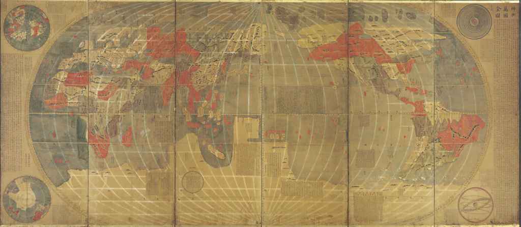
Kunyu Wanguo Quantu (Chinese: 坤輿萬國全圖; pinyin: Kūnyú Wànguó Quántú; literally: "A Map of the Myriad Countries of the World"; Italian: Carta Geografica Completa di tutti i Regni del Mondo, "Complete Geographical Map of all the Kingdoms of the World"), printed in China at the request of the Wanli Emperor during 1602 by the Italian Catholic missionary Matteo Ricci and Chinese collaborators, Mandarin Zhong Wentao and the technical translator, Li Zhizao, is the earliest known Chinese world map with the style of European maps.[1] It has been referred to as the Impossible Black Tulip of Cartography, "because of its rarity, importance and exoticism".[2] The map was crucial in expanding Chinese knowledge of the world. It was later exported to Japan and was influential there as well.
The 1602 Ricci map is a very large, 5 ft (1.52 m) high and 12 ft (3.66 m) wide, woodcut using a pseudocylindrical map projection showing China at the center of the known world.[2] The 1906 Eckert IV map resembles the display of this Chinese map. It is the first map in Chinese to show the Americas. The map's mirror image originally was carved on six large blocks of wood and then printed in brownish ink on six mulberry paper panels, similar to the making of a folding screen.
It portrays both North and South America and the Pacific Ocean with reasonable accuracy. China appropriately is linked to Asia, India, and the Middle East. Europe, the Mediterranean, and Africa also are well delineated.[2] Diane Neimann, a trustee of the James Ford Bell Trust, notes that: "There is some distortion, but what's on the map is the result of commerce, trade and exploration, so one has a good sense of what was known then."[2]
Ti Bin Zhang, first secretary for cultural affairs at the Chinese Embassy in Washington, D.C., said in 2009: "The map represents the momentous first meeting of East and West" and was the "catalyst for commerce
The map includes images and annotations describing different regions of the world. Africa is noted to have the world's highest mountain and longest river. The brief description of North America mentions "humped oxen" or bison (駝峰牛 tuófēngníu), feral horses (野馬, yěmǎ), and names Canada (加拿大, Jiānádá). The map identifies Florida as Huādì (花地), the "Land of Flowers." Several Central and South American places are named, including Guatemala (哇的麻剌, Wādemálá), Yucatan (宇革堂, Yǔgétáng), and Chile (智里, Zhīlǐ).[4]
The map's cartographer, Matteo Ricci, gave a brief description of the discovery of the Americas. "In olden days, nobody had ever known that there were such places as North and South America or Magellanica (using a name that early mapmakers gave to a supposed continent including Australia, Antarctica, and Tierra del Fuego), but a hundred years ago, Europeans came sailing in their ships to parts of the sea coast, and so discovered them."[4]
The Museo della Specola Bologna has in its collection, displayed on the wall of the Globe Room, original copies of panels 1 and 6 of the six panels comprising the 1602 Ricci map. During restoration and mounting, a central panela part of the Doppio Emisfero delle Stelle by the German mathematician and astronomer Johann Adam Schall von Bellwas inserted between the two sections by mistake.
In 1958, Pasquale DElia, sinologist at the University of Rome certified the authenticity of the Chinese maps in this museums possession, (see op. cit.) stating that "it is the third edition of a geographical and cartographical work that made Ricci famous throughout China. He had already made a first edition in 1584 at Shiuhing, followed by a second in 1600 at Nanking, and two years later a third in Peking.[6]
In 1938, an exhaustive work by Pasquale d'Elia, edited by the Biblioteca Apostolica Vaticana, was published with comments, notes, and translation of the whole map.[7] The maps carry plentiful instructions for use and detailed illustrations of the instruments that went into their production, as well as explanations regarding conceptions of "systems of the terrestrial and celestial world".[6] There is a long preface by Matteo Ricci in the middle of the map, where it depicts the Pacific Ocean. DElias translation reads:
"Once I thought learning was a multifold experience and I would not refuse to travel [even] ten thousand Li to be able to question wise men and visit celebrated countries. But how long is a mans life? It is certain that many years are needed to acquire a complete science, based on a vast number of observations: and thats where one becomes old without the time to make use of this science. Is this not a painful thing?
And this is why I put great store by [geographical] maps and history: history for fixing [these observations], and maps for handing them on [to future generations].
Respectfully written by the European Matteo Ricci on 17 August 1602."
The figure of the Nove Cieli (Nine Skies) is printed to the left of the title, illustrated as per sixteenth-century conceptions. The accompanying inscription explains the movement of the planets. The right-hand section (panel 6) has other inscriptions giving general ideas on geography and oceanography. Another inscription records an extract of the Storia dei Mongoli regarding the motions of the Sun. In the top of the left-hand section (panel 1), there is an explanation of eclipses and the method for measuring the Earth and the Moon. Both sections carry the characteristic Jesuit seal, the IHS of the Society of Jesus. At the bottom left, in the Southern Hemisphere, is the name of the Chinese publisher of the map and the date: one day of the first month of autumn in the year 1602.[6]
The map also incorporates an explanation of parallels and meridians, a proof that the sun is larger than the moon, a table showing the distances of planets from the earth, an explanation of the varying lengths of days and nights, and polar projections of the earth that are unusually consistent with its main map.[8]
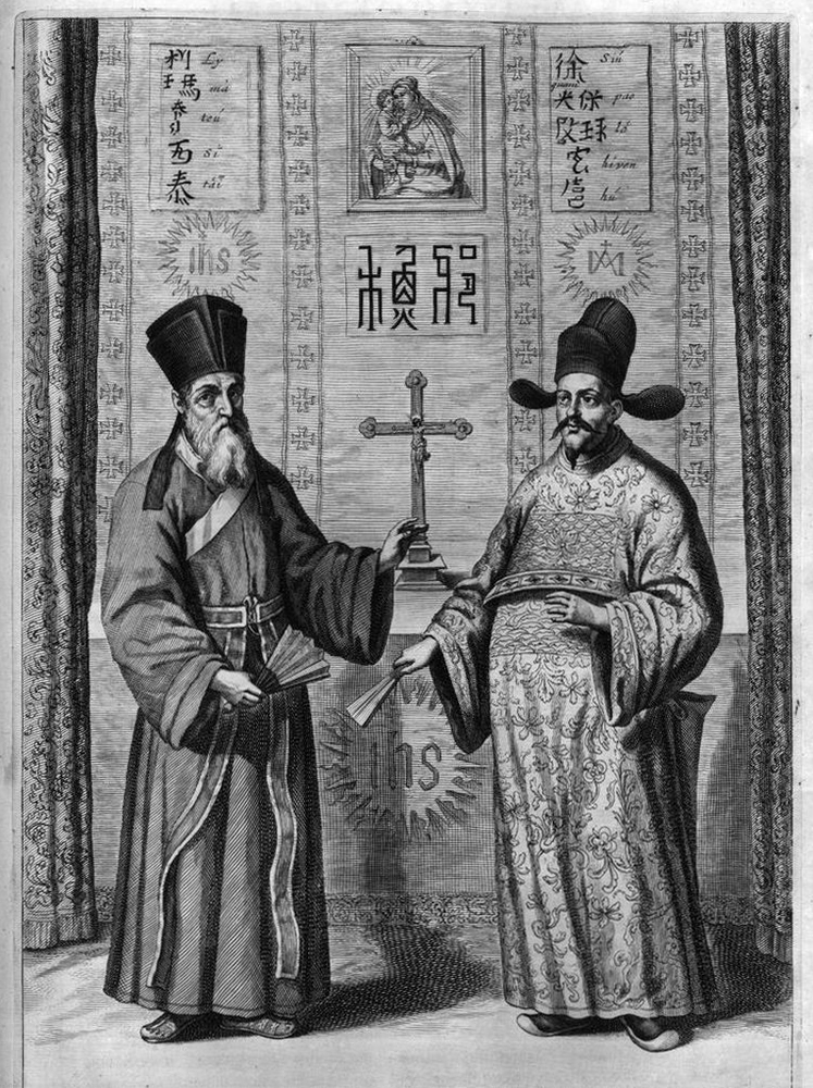
(15521610) was a Jesuit priest. Ricci was one of the first Western scholars to live in China and he became a master of Chinese script and the Classical Chinese language. In 1583, Ricci was among the first Jesuits to enter China from Macao. The first Chinese world map was named Yudi Shanhai Quantu (輿地山海全圖) and made in Zhaoqing in 1584 by Matteo Ricci with Chinese collaborators.[9] Ricci had a small Italian wall map in his possession and created Chinese versions of it at the request of the governor of Zhaoqing at the time, Wang Pan, who wanted the document to serve as a resource for explorers and scholars.[10]
On January 24, 1601, Ricci was the first Jesuit - and one of the first Westerners - to enter the Ming capital Beijing,[6] bringing atlases of Europe and the West that were unknown to his hosts. The Chinese had maps of the East that were equally unfamiliar to Western scholars.
In 1602, at the request of the Wanli Emperor, Ricci collaborated with Mandarin Zhong Wentao, a technical translator, Li Zhizao,[9] and other Chinese scholars in Beijing to create what was his third and largest world map, the Kunyu Wanguo Quantu.[10]
In this map, European geographic knowledge, new to the Chinese, was combined with Chinese information unknown to Europeans to create the first map known to combine Chinese and European cartography.[10] Among other things, this map revealed the existence of America to the Chinese. Ford W. Bell said: "This was a great collaboration between East and West. It really is a very clear example of how trade was a driving force behind the spread of civilization."
According to John D. Day,[11] Matteo Ricci prepared four editions of Chinese world maps during his mission in China before 1603:
a 1584 early woodblock print made in Zhaoqing, called Yudi Shanhai Quantu; a 1596 map carved on a stele, called Shanhai Yudi Tu (山海輿地圖); a 1600 revised version of the 1596, usually named Shanhai Yudi Quantu (山海輿地全圖), engraved by Wu Zhongming; a 1602 larger and much refined edition of the 1584 map, in six panels, printed in Beijing, called Kunyu Wanguo Quantu;[11][12][13][14] Several prints of the Kunyu Wanguo Quantu were made in 1602. Most of the original maps now are lost. Only six original copies of the map are known to exist, and only two are in good condition. Known copies are in the Vatican Apostolic Library Collection I and at the James Ford Bell Library at the University of Minnesota. The Vatican's 1602 copy was reproduced by Pasquale dElia in the beautifully arranged book, Il mappamondo cinese del P Matteo Ricci, S.I. in 1938. This modern work also contains Italian translations of the colophons on the map, a catalogue of all toponyms, plus detailed notes regarding their identification.[11][15]
Other copies of the 1602 map are located at: Japan, Kyoto University Collection; collection of Japan Miyagi Prefecture Library; Collection of the Library of the Japanese Cabinet; and a private collection in Paris, France.[2][10] No original examples of the map are known to exist in China, where Ricci was revered and buried.[4]
The maps received widespread attention and circulation. The governor General of Guizhou reproduced a copy of the map in a book about Guizhou published in Guiyang in 1604. Ricci estimated that more than 1,000 copies of the 1602 edition were reprinted.[16]
Various versions of the map were exported to Japan, and later Korea. An unattributed and very detailed two page coloured edition of the map, known in Japanese as Konyo Bankoku Zenzu, was made in Japan circa 1604. Within this Japanese export copy, Japanese Katakana is utilised for foreign location names throughout the Western world.
The Gonyeomangukjeondo (Hangul: 곤여만국전도) is a Korean hand-copied reproduction print by Painter Kim Jin-yeo in 1708, the 34th year of King Sukjong's rule of Joseon. It shows Kunyu Wanguo Quantu (Complete Map of the World) measuring 533×170 cm on mulberry paper. This map, representing the world in an ellipse, was brought to Korea in the 36th year of King Seonjo's rule (1710) by Lee Gwan-jeong and Gwon Hui, two envoys of Joseon to China. It is owned and displayed at Seoul National University Museum, San 56-1, Sillim-dong, Gwanak-gu, Seoul, Korea and was designated National Treasure No.849 on August 9, 1985.
The map shows five world continents and over 850 toponyms. It contains descriptions of ethnic groups and main products associated with each region. In the margins outside the ellipse, there are images of the northern and southern hemispheres, the Aristotelian geocentric world system, and the orbits of the sun and moon. It has an introduction by Choe Seok-jeong providing information on the constitution of the map and its production process.
This reproduction map provides a clear testimony to the national interest in western maps in 17th-century Korea, it is a highly esthetic piece of work, and one of the most beautiful maps produced during the Joseon period.[17]
Unattributed (1604?), two page colored Japanese copy of the 1602 map Matteo Ricci - Image Database of the Kano Collection, Tohoku University Library[2] Unattributed, very detailed, two page colored edition (1604?), copy of the 1602 map Kunyu Wanguo Quantu by Matteo Ricci at the request of the Wanli Emperor. This digitalization of the map is of a Japanese export copy of the original Chinese version, with phonetic annotations in Katakana for foreign place names outside of the Sinic world, predominantly around Europe, Russia and the Near East.
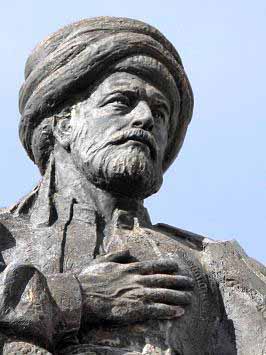
Jesuit Priest Matteo Ricci
Matteo Ricci
Jesuit Matteo Ricci
Matteo Ricci, S.J. (Italian: [matˈtɛːo ˈrittʃi]; October 6, 1552 May 11, 1610), was an Italian Jesuit priest and one of the founding figures of the Jesuit China missions. His 1602 map of the world in Chinese characters introduced the findings of European exploration to East Asia. He is considered a Servant of God in Roman Catholicism.
Ricci arrived at the Portuguese settlement of Macau in 1582 where he began his missionary work in China. He became the first European to enter the Forbidden City of Beijing in 1601 when invited by the Wanli Emperor, who sought his selected services in matters such as court astronomy and calendrical science. He converted several prominent Chinese officials to Catholicism, such as his colleague Xu Guangqi, who aided in translating Euclid's Elements into Chinese as well as the Confucian classics into Latin for the first time.
Posts: 5374 | From: sepedat/sirius | Registered: Jul 2012
| IP: Logged |
An ancient map that strongly suggests Chinese seamen were first round the world Jan 12th 2006 Timekeeper
THE brave seamen whose great voyages of exploration opened up the world are iconic figures in European history. Columbus found the New World in 1492; Dias discovered the Cape of Good Hope in 1488; and Magellan set off to circumnavigate the world in 1519. However, there is one difficulty with this confident assertion of European mastery: it may not be true.
It seems more likely that the world and all its continents were discovered by a Chinese admiral named Zheng He, whose fleets roamed the oceans between 1405 and 1435. His exploits, which are well documented in Chinese historical records, were written about in a book which appeared in China around 1418 called The Marvellous Visions of the Star Raft.
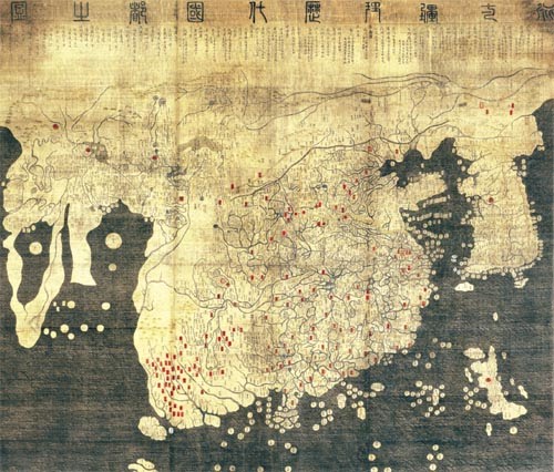
Next week, in Beijing and London, fresh and dramatic evidence is to be revealed to bolster Zheng He's case. It is a copy, made in 1763, of a map, dated 1418, which contains notes that substantially match the descriptions in the book. It will revolutionise our thinking about 15th-century world history, says Gunnar Thompson, a student of ancient maps and early explorers.
In this section China beat Columbus to it, perhaps Better with them than without them A strangely newfangled idea From the theatre of the synagogue Reprints The map (shown above) will be unveiled in Beijing on January 16th and at the National Maritime Museum in Greenwich a day later. Six Chinese characters in the upper right-hand corner of the map say this is a general chart of the integrated world. In the lower left-hand corner is a note that says the chart was drawn by Mo Yi Tong, imitating a world chart made in 1418 which showed the barbarians paying tribute to the Ming emperor, Zhu Di. The copyist distinguishes what he took from the original from what he added himself.
The map was bought for about $500 from a small Shanghai dealer in 2001 by Liu Gang, one of the most eminent commercial lawyers in China, who collects maps and paintings. Mr Liu says he knew it was significant, but thought it might be a modern fake. He showed his acquisition to five experienced collectors, who agreed that the traces of vermin on the bamboo paper it is written on, and the de-pigmentation of ink and colours, indicated that the map was more than 100 years old.
Mr Liu was unsure of its meaning, and asked specialists in ancient Chinese history for their advice, but none, he says, was forthcoming. Then, last autumn, he read 1421: The Year China Discovered the World, a book written in 2003 by Gavin Menzies, in which the author makes the controversial claim that Zheng He circumnavigated the world, discovering America on the way. Mr Menzies, who is a former submariner in the Royal Navy and a merchant banker, is an amateur historian and his theory met with little approval from professionals. But it struck a chord: his book became a bestseller and his 1421 website is very popular. In any event, his arguments convinced Mr Liu that his map was a relic of Zheng He's earlier voyages.
Advertisement
The detail on the copy of the map is remarkable. The outlines of Africa, Europe and the Americas are instantly recognisable. It shows the Nile with two sources. The north-west passage appears to be free of ice. But the inaccuracies, also, are glaring. California is shown as an island; the British Isles do not appear at all. The distance from the Red Sea to the Mediterranean is ten times greater than it ought to be. Australia is in the wrong place (though cartographers no longer doubt that Australia and New Zealand were discovered by Chinese seamen centuries before Captain Cook arrived on the scene).
The commentary on the map, which seems to have been drawn from the original, is written in clear Chinese characters which can still be easily read. Of the west coast of America, the map says: The skin of the race in this area is black-red, and feathers are wrapped around their heads and waists. Of the Australians, it reports: The skin of the aborigine is also black. All of them are naked and wearing bone articles around their waists.
But this remarkable precision, rather than the errors, is what critics of the Menzies theory are likely to use to question the authenticity of the 1418 map. Mr Menzies and his followers are naturally extremely keen to establish that the 1763 copy is not a forgery and that it faithfully represents the 1418 original. This would lend weighty support to their thesis: that China had indeed discovered America by (if not actually in) 1421. Mass spectrography analysis to date the copied map is under way at Waikato University in New Zealand, and the results will be announced in February. But even if affirmative, this analysis is of limited importance since it can do no more than date the copyist's paper and inks.
Five academic experts on ancient charts note that the 1418 map puts together information that was available piecemeal in China from earlier nautical maps, going back to the 13th century and Kublai Khan, who was no mean explorer himself. They believe it is authentic.
The map makes good estimates of the latitude and longitude of much of the world, and recognises that the earth is round. The Chinese were almost certainly aware of longitude before Zheng He set sail, says Robert Cribbs of California State University. They certainly assumed the world was round. The format of the map is totally consistent with the level of knowledge that we should expect of royal Chinese geographers following the voyages of Zheng He, says Mr Thompson.
Moreover, some of the errors in the 1418 map soon turned up in European maps, the most striking being California drawn as an island. The Portuguese are aware of a world map drawn before 1420 by a cartographer named Albertin di Virga, which showed Africa and the Americas. Since no Portuguese seamen had yet discovered those places, the most obvious source for the information seems to be European copies of Chinese maps.
But this is certainly not a unanimous view among the experts, with many of the fiercest critics in China itself. Wang Tai-Peng, a scholarly journalist in Vancouver who does not doubt that the Chinese explored the world early in the 15th century (he has written about a visit by Chinese ambassadors to Florence in 1433), doubts whether Zheng He's ships landed in North America. Mr Wang also claims that Zheng He's navigation maps were drawn in a totally different Chinese map-making tradition. Until the 1418 map is scientifically authenticated, we still have to take it with a grain of salt, he says.
Most forgeries are driven by a commercial imperative, especially when the market for ancient maps is booming, as it is now. The Library of Congress recently paid $10m for a copy of a 1507 world map by Martin Waldseemuller, a German cartographer. But Mr Liu says he is not a seller: The map is part of my life, he claims.
The consequences of the discovery of this map could be considerable. If it does indeed prove to be the first map of the world, the history of New World discovery will have to be rewritten, claims Mr Menzies. How much does this matter? Showing that the world was first explored by Chinese rather than European seamen would be a major piece of historical revisionism. But there is more to history than that. It is no less interesting that the Chinese, having discovered the extent of the world, did not exploit it, politically or commercially. After all, Columbus's discovery of America led to exploitation and then development by Europeans which, 500 years later, made the United States more powerful than China had ever been.
Steven Dutch, Natural and Applied Sciences, University of Wisconsin - Green Bay First-time Visitors: Please visit Site Map and Disclaimer. Use "Back" to return here.
Recently (January 2006) a lot of interest has developed around a Chinese map that purportedly shows the Americas in detail. The text of the map says the map was drawn in 1763 but is a copy of a map from 1418. Not only does the map show the Isthmus of Panama accurately, it even shows what appears to be Antarctica. Needless to say, believers in ancient astronauts, Atlantis, and pre-Columbian global voyages by the Chinese are all a-twitter. So far, nobody has drifted into pseudoscience, but this map will probably achieve a status like the Piri Reis Map.
Above is a simplified version of the map traced from press photographs. Europe and Africa are on the far left, Asia left of center, and the Americas on the right.
First, what areas on the map are drawn with fair accuracy? Three areas stand out: Africa, Central America and Panama, and northern China. More crudely drawn but recognizable features include the Mediterranean, Hudson's Bay and the Bering Strait. Then there are a number of significant errors, omissions, and non-existent features as well.
So what parts of the world are shown so well that the provenance of the map is obvious? The surprising answer is that no part of the world is drawn with very high accuracy.
Above is the map with significant features located. In several cases, labels identify what some interpreters claim to see, and do not indicate that the identifications are correct.
China
Since the text on the map is Chinese, the map is obviously Chinese. Starting with China, the Shandong Peninsula (SP) and Korea (K) are obvious. They enclose the Gulf of Bohai. The Liao River (L) flows into the gulf and makes a sharp bend as shown, although it doesn't extend nearly as far west as the map indicates. The large river emptying north of Korea (A) could be the Amur.
Here's where it gets strange. The great square bend of the Huang He (H) is obvious and unmistakable. The Huang He has switched course repeatedly from north to south of the Shandong Peninsula, so having the mouth south of the peninsula instead of north like it is now is no problem. But the lower course of the Huang He, either side of the peninsula, is fairly straight. The zigzag bends shown (Y) are a nearly perfect match for the lower Yangtze, however.
One possibility is that the cartographer confused the two rivers, about equivalent to an American mixing up the Mississippi and the Rio Grande. Another is that the map dates from a time when the Huang He flowed in a southerly course, but even then the two rivers would have joined well downstream from the major bends in the Yangtze. At the very least, the Yangtze is a major artery of commerce in China and should at least be shown as a major tributary. The unidentified river emptying north of the Shandong Peninsula could be one of the rivers that carries the Huang He flow when it has a northerly course.
Further afield, we can recognize Japan (J), although it is crudely shown. Hainan (H) and Taiwan (T) are recognizable, and the large river emptying near Hainan could be either the Si Kiang or the Red River. Southeast Asia (SEA) is extremely crude as is Indonesia (Ind).
Altogether, China as represented on this map does not achieve the accuracy that the Chinese were perfectly capable of achieving long before 1418. The accuracy of the Gulf of Bohai and the disproportionately large size of that region on the map point pretty conclusively to the map being drawn by someone from northern China. But his knowledge even of Chinese geography once he gets far from home is shaky. Areas the Chinese would have known well, like Japan and Indonesia, are extremely crude. On the other hand, the possible Amur River, and the elongated island north of Japan (Sakhalin?) hint that the cartographer had unusually good awareness of areas immediately north of China. Might he have originally been Korean or Japanese?
Africa and Europe
The general shape of Africa is clearly visible, and major rivers like the Congo (C) and Orange (O) are identifiable. Madagascar (Mad) is represented. The large river in west Africa could be the Gambia (G) but possibly also the Niger. The Nile (N) has a correctly located mouth but is shown as only a minor river. There are no large rivers emptying from east Africa as shown on the map. The Red Sea (RS) is shown, but not the Persian Gulf! (Ar is Arabia) Certainly from their dealings with Arab traders the Chinese would have had accurate knowledge of the Indian Ocean and South Asia, but it is not represented on this map. India (In) is shown and the major river east of it is clearly the Ganges, but the Indus is not shown, nor is Ceylon. If the map used European information about Africa (using other maps than the 1418 source cited) it's odd that Ceylon isn't shown, considering how large Ceylon loomed in European fantasies.
Europe is crudely represented with vague hints of Italy and Greece. Three bodies of inland water are shown, which may be the Black Sea (BS), Caspian Sea (CS) and Aral Sea (AS). Britain and the Baltic are not shown, but there is a large non-existent island (1) west of Spain. The large south-flowing river (6) might be the Rhone.
The Americas
The only part of the Americas that is at all eye-catching for accuracy is the Isthmus of Panama (P). The large river emptying into a deep gulf is probably the St. Lawrence (SL). The other large river (M) might be the Mississippi although it could potentially be any major river. Neither the Gulf of Mexico nor Florida are shown, and the Caribbean islands are so vague as to be unidentifiable. The islands offshore (2) might refer to the Antilles. The large river (5) emptying into the Pacific is unknown. It could be the Sacramento or the Columbia, or even the Colorado. The large river (4) emptying out of the west coast of South America simply does not exist. Note, too, that the Amazon is not shown.
Often, it's not what someone gets right that's informative, but what he gets wrong. Baja California (BC) is shown as an island. Francisco de Ulloa finally showed Baja California was a peninsula in 1539, but well into the next century non-Spanish European maps persisted in showing California as an island. Below are two examples, both from the 1600's. The first is by John Speed, the second by Nicholas Sanson. Note that both show Hudson's Bay and some Arctic islands.
When someone presents accurate information, it may have been copied or derived independently. When the information makes the same mistakes as an inaccurate source, the case for copying becomes ironclad. The cartography on the Chinese map is so similar to the maps above that it simply screams "European source."
The large island between North America and Europe could well be Greenland (Gr). A large non-existent north polar land mass (3) is shown, although this could be a reference to Canadian Arctic islands. The large bay on the northern coast of North America is probably Hudson's Bay (HB).
Other Regions
"Australia" (Au), "New Zealand" (NZ) and "Antarctica" (An) are labeled. Even before European contact, the Chinese would probably have known of Australia. It would be hard for them not to. However, it's shown as a generic round land mass in mid-Pacific, with no cartographic accuracy at all. If the map accurately shows Antarctica (An), what are we to make of the imaginary land mass in the Arctic (3)?
The large river emptying into the Siberian arctic (7) could be the Ob or the Yenisei. The Chinese would certainly have known that rivers in Mongolia and Central Asia flow north, so hypothesizing such a river is not remarkable.
The gap between Asia and North America may or may not reflect knowledge of the Bering Strait. There are only two possible choices in drawing a map; they are either connected, or they are not. Early maps of the Americas showed it both ways. The fact that the Kamchatka Peninsula is completely missing casts serious doubt on the cartographer having any real geographic knowledge of this region.
With the exception of his home region of northern China, the cartographer's accuracy on inland features is zero. He fails to show the Indus or the Himalaya, or the bend in the Ganges. Mountains are scattered randomly with no correspondence at all to real ranges.
Conclusions
Let's assume the map genuinely dates from 1763 (not a modern fake) and incorporates data from earlier Chinese maps that may actually go back as far as 1418. However, let's also consider the possibility that the cartographer incorporated other data as well. He need not have been plagiarizing, but simply synthesizing all the geographic information he had available.
The accuracy for northern China and its disproportionate size point to that region being the home of the cartographer. The overall cartographic quality is poor even within China and regions well known to the Chinese. The poor quality of areas that should be well mapped argue convincingly against the map showing the discoveries of globe-girdling voyages. The accuracy of Africa indicates the cartographer had access to maps. If the maps were European (Africa was circumnavigated in 1498) the crudeness of Europe is a puzzle. On the other hand, the coast of Africa is a mass of generic and non-existent wiggles, so perhaps the two continents are not that dissimilar in accuracy after all. If the Chinese visited the Pacific coast of North America, they almost certainly came down from the north. You can't make the mistake of thinking Baja California is an island from that direction. You can, however, by sailing up from the south if you conclude that the mouth of the Gulf of California is a strait but you haven't yet explored its whole length. That's what the Spanish did at first. Either the Chinese made exactly the same mistake as the Spanish, or this part of the map is copied from a European map. The portrayal of Greenland and Hudson's Bay suggest that the cartographer had access to information from explorers like Frobisher and Hudson (late 1500's and early 1600's).
Gangnido map
Kangnido map
The Honil Gangni Yeokdae Gukdo Ji Do ("Map of Integrated Lands and Regions of Historical Countries and Capitals."[1]), often abbreviated as Kangnido, is a world map created in Korea, produced by Yi Hoe and Kwon Kun in 1402.[2]
The Kangnido is one of the oldest surviving world maps from East Asia, along with the (ca. 1398) Chinese Da Ming Hun Yi Tu.[3] Surviving copies of both the Kangnido and the Da Ming Hun Yi Tu all bear later revisions, and the original, unrevised forms of both maps are uncertain. Nevertheless, the surviving copies of the Kangnido constitute one of the most important materials for reconstructing the original form of the 14th-century Chinese map. As a world map, it reflects the geographic knowledge of China during the Mongol Empire when geographical information about Western countries became available via Islamic geographers.[4]
It depicts the general form of the Old World, from Africa and Europe in the west to Japan in the east.[5] Although, overall, it is less geographically accurate than its Chinese cousin, most obviously in the depiction of rivers and small islands, it does feature some improvements (particularly the depictions of Korea and Japan, and a less cramped version of Africa).
Posts: 5374 | From: sepedat/sirius | Registered: Jul 2012
| IP: Logged |
Piri Reis was an Ottoman Kaptan-i Derya, geographer and cartographer born between 1465 and 1470 and died in 1554 or 1555. He is primarily known today for his maps and charts collected in his Kitab-i Bahriye (Book of Navigation), a book which contains detailed information on navigation as well as very accurate for its time charts describing the important ports and cities of the Mediterranean Sea.
Little is known about the identity of Piri Reis. Even the name roughly translated means "sea captain". His origin is debatable, with sources referring to him as Christian, possibly Greek, Jewish, or ethnic Turkish. Hadji Ahmed Muhiddin Piri was born either in Gallipoli of the European part of the Ottoman Empire or in Karaman, central Anatolia, but the exact date of his birth is unknown.
He was son of Hadji Mehmed Piri, and began engaging in piracy when he was young, in 1481, following his uncle Kemal Reis, a well-known pirate and seafarer of the time who later became famous Admiral of the Ottoman fleet. During the periods the Ottomans were at war, together with his uncle, he took part in many naval fights against Spanish, Genoese and Venetians, including the First Battle of Lepanto (Battle of Zonchio) in 1499 and Second Battle of Lepanto (Battle of Modon) in 1500. When his uncle Kemal Reis drowned in 1511 when his ship wrecked by a storm, Piri returned to Gallipoli where he started working his study about navigation.
He gained fame as a cartographer when a small part of his first world map (prepared in 1513) was discovered in 1929 at Topkapő Palace in Istanbul. His world map is the oldest known Turkish atlas showing the New World, and one of the oldest maps of America still in existence in the world. (The oldest known map of America that is still in existence is the map drawn by Juan de la Cosa in 1500, which is conserved in the Naval Museum (Museo Naval) of Madrid, Spain.) Piri Reis' map is centered in Sahara at the Tropic of Cancer latitude.
By 1516 he was again at sea as a ship's captain in the Ottoman fleet. He took part in the 1516-17 campaign against Egypt. In 1522 he participated in the siege of Rhodes against the Knights of St. John which ended with the island's surrender to the Ottomans on December 25, 1522 and the permanent departure of the Knights from Rhodes on January 1, 1523. In 1524 he captained the ship that took the tragic Vizier Pargali Ibrahim Pasha to Egypt.
In 1547, Piri had risen to the rank of Reis (admiral) as commander of the Ottoman fleet in the Indian Ocean and admiral of the fleet in Egypt, headquartered at Suez.
On February 26, 1548 he recaptured Aden from the Portuguese in the Capture of Aden, followed in 1552 by the Capture of Muscat, which Portugal had occupied since 1507, and the important island of Kish. Turning further east, Piri Reis captured the island of Hormuz in the Strait of Hormuz, at the entrance of the Persian Gulf. When the Portuguese turned their attention to the Persian Gulf, Piri Reis occupied the Qatar peninsula and the island of Bahrain to deprive the Portuguese of suitable bases on the Arabian coast.
He then returned to Egypt, an old man approaching the age of 90. When he refused to support the Ottoman governor of Basra, Kubad Pasha, in another campaign against the Portuguese in the northern Persian Gulf, Piri Reis was publicly beheaded in 1554 or 1555.
Several warships and submarines of the Turkish Navy have been named after Piri Reis.
In the News ...
Piri Reis Map: Evidence of a Very Advanced Prehistoric Civilization? Epoch Times - December 29, 2014 A map created by Turkish admiral and cartographer Piri Reis in 1513 has intrigued scholars both mainstream and alternative since it was discovered in Istanbul's Topkapi Palace in 1929. On the alternative side, it's said that this map may show Antarctica hundreds of years before the continent was discovered (it was discovered in 1818). Furthermore, it is said to depict Antarctica as it was in a very remote age, before it was covered with ice.
Piri Reis Map
Surviving fragment of the first World Map of Piri Reis (1513)
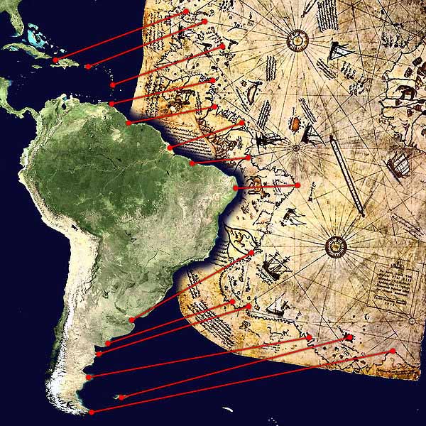
The Piri Reis map is a pre-modern world map compiled in 1513 from military intelligence by the Ottoman-Turkish admiral and cartographer Piri Reis. The half of the map that survives shows the western coasts of Europe and North Africa and the coast of Brazil with reasonable accuracy. Various Atlantic islands including the Azores and Canary Islands are depicted, as is the mythical island of Antillia and possibly Japan. The historical importance of the map lies in its demonstration of the extent of exploration of the New World by approximately 1510, perhaps before others. It used 10 Arabian sources, 4 Indian maps sourced from Portuguese and one map of Columbus.
Description
The map is the extant western third of a world map drawn on gazelle skin, with dimensions reported as 90 cm x 63 cm, 86 cm x 60 cm, 90 cm x 65 cm, 85 cm x 60 cm, 87 cm x 63 cm, and 86 cm x 62 cm. These discrepancies are largely due to the damaged corner. The surviving portion primarily details the western coast of Africa and the eastern coast of South America.
The map was signed by Piri Reis, an Ottoman-Turkish admiral, geographer and cartographer, and dated to the month of Muharram in the Islamic year 919 AH, equivalent to 1513 AD. It was presented to Ottoman Sultan Selim I in 1517. In the map's legend, Piri inscribed that the map was based on about twenty charts and mapper mundi - a general term used to describe medieval European maps of the world..
According to Piri, these maps included eight Ptolemaic maps constructed during the era of Alexander the Great, an Arabic map of India, four newly drawn Portuguese maps from Sindh, Pakistan and a map by Christopher Columbus of the western lands. From Inscription 6 on the map:
From eight Jaferyas of that kind and one Arabic map of Hind [India], and from four newly drawn Portuguese maps which show the countries of Sind [modern day Pakistan], Hind and Cin [China] geometrically drawn, and also from a map drawn by Qulunbu [Columbus] in the western region, I have extracted it. By reducing all these maps to one scale this final form was arrived at, so that this map of these lands is regarded by seamen as accurate and as reliable as the accuracy and reliability of the Seven Seas on the aforesaid maps." There is some scholarly debate over whether the 20 charts and mappae mundi in Piri's inscriptions includes the eight Ptolemaic maps, the four Portuguese maps, the Arabic map and the Columbus map. From one perspective, the number of charts and mappae mundi used by Piri equals 20, while in the other, it could mean a total of 34.
Some researchers have claimed that the source maps were found in the ancient Library of Alexandria, based on Piri's allusions to Alexander the Great, the founder of Alexandria, Ptolemy I, who ruled Alexandria in the 4th century BC, and Claudius Ptolemy, the Greek geographer and cartographer who lived in Alexandria during the second century AD.
History
The map was discovered serendipitously on October 9, 1929, through the philological work of the German theologian, Gustav Adolf Deissmann (1866-1937). He had been commissioned by the Turkish Ministry of Education to catalogue the Topkapő Sarayi library's non-Islamic items. At Deissmann's request to search the palace for old maps and charts, the director Halil Edhem (1861-1938) managed to find some disregarded bundles of material, which he handed over to Deissmann. Realizing that the map might be a unique find, Deissmann showed it to the orientalist Paul Kahle who identified it as a map drawn by Piri Reis.
The discovery caused an international sensation, as it represented the only then known copy of a world map of Christopher Columbus (1451-1506), and was the only 16th century map that showed South America in its proper longitudinal position in relation to Africa. Geographers had spent several centuries unsuccessfully searching for a "lost map of Columbus" that was supposedly drawn while he was in the West Indies.
After reading about the map's discovery in The Illustrated London News, United States Secretary of State Henry L. Stimson contacted the United States Ambassador to Turkey Charles H. Sherrill and requested that an investigation be launched to find the Columbus source map, which he believed may have been in Turkey. In turn, the Turkish government complied with Stimson's request, but they were unsuccessful in locating any of the source maps.
The Piri Reis map is currently located in the Library of the Topkapő Palace in Istanbul, Turkey, but is not usually on display to the public.
The map was depicted on the reverse of the Turkish 10 million lira banknote of 1999-2005 and of the 10 new lira banknote of 2005-2009.
Surviving fragment of the second World Map of Piri Reis (1528) In 1528 Piri Reis drew a second world map, of which a small fragment (showing Greenland and North America from Labrador and Newfoundland in the north to Florida, Cuba and parts of Central America in the south) still survives. According to his imprinting text he had drawn his maps using about twenty foreign charts and mappa mundi (Arab, Spanish, Portuguese, Chinese, Indian and Greek) including one of Christopher Columbus.
"Kitab-Bahriye" ("Book of Navigation"): 1521 and 1525
Comparison between a modern projection of South America and Piri Reis's version.
Piri Reis is the author of the Kitab-i Bahriye one of the most famous pre modern books of navigation including a world map. Although he was not an explorer and never sailed to the Atlantic, by making use, according to the imprinting, of about twenty Arab, Spanish, Portuguese, Chinese, Indian and older Greek maps, he managed to give a comprehensive representation of the known world of his era including the recently explored shores of both Atlantic African and American continents (imprinted "These lands and islands are drawn from map of Columbus").
In his text he is also giving as source "maps drawn in the time of Alexander the Great", but most likely he had mistakenly confused the ancient Greek geographer Ptolemy of the 2nd century AD with the same named General of Alexander (of six centuries before) since his map is similar with the Jan of Stobnica famous reproduction map of Ptolemy, printed at 1512.
The ancient book had been translated in Turkish after a personal order of Mehmed II some decades before.
The Columbus origin of the Atlantic part of the map is confirmed by the contained errors (such as Columbus' belief that Cuba was a continental peninsula) since at the time the manuscript produced, the Spaniards were already for two years in Mexico. Apart of the maps, the book also contained detailed information on the major ports, bays, gulfs, capes, peninsulas, islands, straits and ideal shelters of the Mediterranean Sea, as well as techniques of navigation and navigation-related information on astronomy, together with information about the local people of each country and city and the curious aspects of their culture.
There are thirty legends around the world map, twenty-nine in Turkish and one in Arabic, the latter is giving the date as the Muharrem month of 919 AH (corresponding to spring 1513 AD) but most studies identify as more probable date the 1521. It was revised in 1524-5 with additional information and better-crafted charts in order to be presented as a gift to Suleiman I. The revised edition had a total of 434 pages containing 290 maps.
Kitab-i Bahriye has two main sections, with the first section dedicated to information about the types of storms, techniques of using a compass, portolan charts with detailed information on ports and coastlines, methods of finding direction using the stars, characteristics of the major oceans and the lands around them. Special emphasis is given to the discoveries in the New World by Christopher Columbus and those of Vasco da Gama and the other Portuguese seamen on their way to India and the rest of Asia.
The second section is entirely composed of portolan charts and cruise guides. Each topic contains the map of an island or coastline. In the first book (1521), this section has a total of 132 portolan charts, while the second book (1525) has a total of 210 portolan charts.
The second section starts with the description of the Dardanelles Strait and continues with the islands and coastlines of the Aegean Sea, Ionian Sea, Adriatic Sea, Tyrrhenian Sea, Ligurian Sea, the French Riviera, the Balearic Islands, the coasts of Spain, the Strait of Gibraltar, the Canary Islands, the coasts of North Africa, Egypt and the River Nile, the Levant and the coastline of Anatolia. This section also includes descriptions and drawings of the famous monuments and buildings in every city, as well as biographic information about Piri Reis who also explains the reasons why he preferred to collect these charts in a book instead of drawing a single map, which would not be able to contain so much information and detail.
A century after Piri's death and during the second half of the 17th century a third version of his book was produced which left the text of the second version unaffected while enriching the cartographical part of the manuscript. It included additional new large-scale maps mostly copies of Italian (from Battista Agnese and Jacopo Gastaldi) and Dutch (Abraham Ortelius) works of the previous century. These maps were much more accurate and depict the Black Sea which was not comprised in the original.
Copies of the Kitab-i Bahriye are found in many libraries and museums around the world.
Copies of the first edition (1521) are found in the Topkapi Palace, the Nuruosmaniye Library and the Suleymaniye Library in Istanbul, the Library of the University of Bologna, the National Library of Vienna, the State Library of Dresden, the National Library of France in Paris, the British Museum in London, the Bodleian Library in Oxford and the Walters Art Museum in Baltimore.
Copies of the second edition (1525) are found in the Topkapő Palace, the Kopruluzade Fazől Ahmed Pasa Library, the Suleymaniye Library and the National Library of France.
The Aegean Sea
Charles Hapgood
Charles Hapgood began studying the map in the middle of the 20th century and published the book Maps of the Ancient Sea Kings in 1966.
Hapgood claims this and other maps support a theory of global exploration by a pre-classical undiscovered civilization. He supports this with an analysis of the mathematics of ancient maps and of their accuracy, which he says surpassed instrumentation available at the time of the map's drafting.
Hapgood argued that owing to the map being assembled from components, the Caribbean section was rotated nearly 90Ľ from the top of South America. He attributed this to either copying from a polar projection, or to fit in the space available by hinging the map at that location and giving it an "alternate north", of which other examples are known in maps of the era.
Posts: 5374 | From: sepedat/sirius | Registered: Jul 2012
| IP: Logged |


 UBBFriend: Email this page to someone!


 Printer-friendly view of this topic