posted
This decorative tile from a royal palace made between 1184 and 1153 BC and found in Tell el-Yahudiyah shows a Libyan captive. British Museum
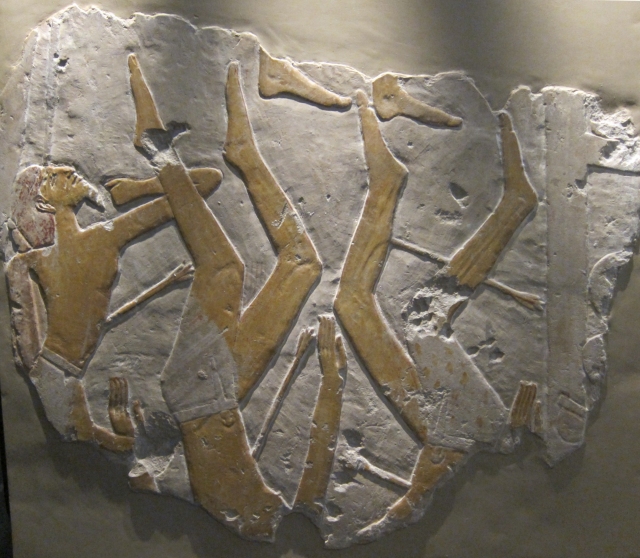
limestone relief fragment was once part of a large composition showing a siege of a near eastern city. British Museum
Posts: 42918 | From: , | Registered: Jan 2010
| IP: Logged |
posted
.The exact boundaries of Ancient Libya are unknown. It lay west of Ancient Egypt and was known as "IMNT" to the Ancient Egyptians. Libya was an unknown territory to the Egyptians: it was the lands of the spirits.
Map of the world according to Herodotus To the Ancient Greeks, Libya was one of the three known continents along with Asia and Europe. In this sense, Libya was the whole known African continent to the west of the Nile Valley and extended south of Egypt.
Herodotus described the inhabitants of Libya as two peoples: The Libyans in northern Africa and the Ethiopians in the south.
Possibly what the world according to Herodotus looked like (5th century BC).
_______________________________________
Ancient History Sourcebook: Herodotus (c.490-c.425 BCE):
On Libya, from The Histories, c. 430 BCE (Carthage also mentioned)
In the accounts here, Herodotus describes thepeoples and geography of North Africa west of Egypt - much further west than the current boundaries of modern Libya. These texts aslo form part of a larger file on North Africa/Mauretania in ancient sources.
Book IV.42-43
For my part I am astonished that men should ever have divided Libya, Asia, and Europe as they have, for they are exceedingly unequal. Europe extends the entire length of the other two, and for breadth will not even (as I think) bear to be compared to them. As for Libya, we know it to be washed on all sides by the sea, except where it is attached to Asia. This discovery was first made by Necos, the Egyptian king, who on desisting from the canal which he had begun between the Nile and the Arabian gulf [i.e., the Red Sea], sent to sea a number of ships manned by Phoenicians, with orders to make for the Pillars of Hercules, and return to Egypt through them, and by the Mediterranean. The Phoenicians took their departure from Egypt by way of the Erythraean sea, and so sailed into the southern ocean. When autumn came, they went ashore, wherever they might happen to be, and having sown a tract of land with corn, waited until the grain was fit to cut. Having reaped it, they again set sail; and thus it came to pass that two whole years went by, and it was not till the third year that they doubled the Pillars of Hercules, and made good their voyage home. On their return, they declared - I for my part do not believe them, but perhaps others may - that in sailing round Libya they had the sun upon their right hand. In this way was the extent of Libya first discovered.
Next to these Phoenicians the Carthaginians, according to their own accounts, made the voyage. For Sataspes, son of Teaspes the Achaemenian, did not circumnavigate Libya, though he was sent to do so; but, fearing the length and desolateness of the journey, he turned back and left unaccomplished the task which had been set him by his mother. This man had used violence towards a maiden, the daughter of Zopyrus, son of Megabyzus, and King Xerxes was about to impale him for the offence, when his mother, who was a sister of Darius, begged him off, undertaking to punish his crime more heavily than the king himself had designed. She would force him, she said, to sail round Libya and return to Egypt by the Arabian gulf. Xerxes gave his consent; and Sataspes went down to Egypt, and there got a ship and crew, with which he set sail for the Pillars of Hercules. Having passed the Straits, he doubled the Libyan headland, known as Cape Soloeis, and proceeded southward.
Following this course for many months over a vast stretch of sea, and finding that more water than he had crossed still lay ever before him, he put about, and came back to Egypt. Thence proceeding to the court, he made report to Xerxes, that at the farthest point to which he had reached, the coast was occupied by a dwarfish race, who wore a dress made from the palm tree. These people, whenever he landed, left their towns and fled away to the mountains; his men, however, did them no wrong, only entering into their cities and taking some of their cattle. The reason why he had not sailed quite round Libya was, he said, because the ship stopped, and would no go any further. Xerxes, however, did not accept this account for true; and so Sataspes, as he had failed to accomplish the task set him, was impaled by the king's orders in accordance with the former sentence.
Book IV.168-198
The Libyans dwell in the order which I will now describe. Beginning on the side of Egypt, the first Libyans are the Adyrmachidae. These people have, in most points, the same customs as the Egyptians, but use the costume of the Libyans. Their women wear on each leg a ring made of bronze; they let their hair grow long, and when they catch any vermin on their persons, bite it and throw it away. In this they differ from all the other Libyans. They are also the only tribe with whom the custom obtains of bringing all women about to become brides before the king, that he may choose such as are agreeable to him. The Adyrmachidae extend from the borders of Egypt to the harbor called Port Plynus. Next to the Adyrmachidae are the Gilligammae, who inhabit the country westward as far as the island of Aphrodisias. Off this tract is the island of Platea, which the Cyrenaeans colonized. Here too, upon the mainland, are Port Menelaus, and Aziris, where the Cyrenaeans once lived. The Silphium begins to grow in this region, extending from the island of Platea on the one side to the mouth of the Syrtis on the other. The customs of the Gilligammae are like those of the rest of their countrymen.
The Asbystae adjoin the Gilligammae upon the west. They inhabit the regions above Cyrene, but do not reach to the coast, which belongs to the Cyrenaeans. Four-horse chariots are in more common use among them than among any other Libyans. In most of their customs they ape the manners of the Cyrenaeans. Westward of the Asbystae dwell the Auschisae, who possess the country above Barca, reaching, however, to the sea at the place called Euesperides. In the middle of their territory is the little tribe of the Cabalians, which touches the coast near Tauchira, a city of the Barcaeans. Their customs are like those of the Libyans above Cyrene.
The Nasamonians, a numerous people, are the western neighbors of the Auschisae. In summer they leave their flocks and herds upon the sea-shore, and go up the country to a place called Augila, where they gather the dates from the palms, which in those parts grow thickly, and are of great size, all of them being of the fruit-bearing kind. They also chase the locusts, and, when caught, dry them in the sun, after which they grind them to powder, and, sprinkling this upon their milk, so drink it. Each man among them has several wives, in their intercourse with whom they resemble the Massagetae. The following are their customs in the swearing of oaths and the practice of augury. The man, as he swears, lays his hand upon the tomb of some one considered to have been pre-eminently just and good, and so doing swears by his name. For divination they betake themselves to the sepulchers of their own ancestors, and, after praying, lie down to sleep upon their graves; by the dreams which then come to them they guide their conduct. When they pledge their faith to one another, each gives the other to drink out of his hand; if there be no liquid to be had, they take up dust from the ground, and put their tongues to it.
On the country of the Nasamonians borders that of the Psylli, who were swept away under the following circumstances. The south-wind had blown for a long time and dried up all the tanks in which their water was stored. Now the whole region within the Syrtis is utterly devoid of springs. Accordingly the Psylli took counsel among themselves, and by common consent made war upon the southwind---so at least the Libyans say, I do but repeat their words---they went forth and reached the desert; but there the south-wind rose and buried them under heaps of sand: whereupon, the Psylli being destroyed, their lands passed to the Nasamonians.
Above the Nasamonians, towards the south, in the district where the wild beasts abound, dwell the Garamantians, who avoid all society or intercourse with their fellow-men, have no weapon of war, and do not know how to defend themselves. These border the Nasamonians on the south: westward along the sea-shore their neighbors are the Macea, who, by letting the locks about the crown of their head grow long, while they clip them close everywhere else, make their hair resemble a crest. In war these people use the skins of ostriches for shields. The river Cinyps rises among them from the height called "the Hill of the Graces," and runs from thence through their country to the sea. The Hill of the Graces is thickly covered with wood, and is thus very unlike the rest of Libya, which is bare. It is distant two hundred furlongs from the sea. Adjoining the Macae are the Gindanes, whose women wear on their legs anklets of leather. Each lover that a woman has gives her one; and she who can show the most is the best esteemed, as she appears to have been loved by the greatest number of men.
A promontory jutting out into the sea from the country of the Gindanes is inhabited by the Lotophagi, who live entirely on the fruit of the lotus-tree. The lotus fruit is about the size of the lentisk berry, and in sweetness resembles the date. The Lotophagi even succeed in obtaining from it a sort of wine. The sea-coast beyond the Lotophagi is occupied by the Machlyans, who use the lotus to some extent, though not so much as the people of whom we last spoke. The Machlyans reach as far as the great river called the Triton, which empties itself into the great lake Tritonis. Here, in this lake, is an island called Phla, which it is said the Lacedaemonians were to have colonized, according to an oracle.
The following is the story as it is commonly told. When Jason had finished building the Argo at the foot of Mount Pelion, he took on board the usual hecatomb, and moreover a brazen tripod. Thus equipped, he set sail, intending to coast round the Peloponnese, and so to reach Delphi. The voyage was prosperous as far as Malea; but at that point a gale of wind from the north came on suddenly,
and carried him out of his course to the coast of Libya; where, before he discovered the land, he got among the shallows of Lake Tritonis. As he was turning it in his mind how he should find his way out, Triton (they say) appeared to him, and offered to show him the channel, and secure him a safe retreat, if he would give him the tripod. Jason complying, was shown by Triton the passage through the shallows; after which the god took the tripod, and, carrying it to his own temple, seated himself upon it, and, filled with prophetic fury, delivered to Jason and his companions a long prediction. "When a descendant," he said, "of one of the Argo's crew should seize and carry off the brazen tripod, then by inevitable fate would a hundred Grecian cities be built around Lake Tritonis." The Libyans of that region, when they heard the words of this prophecy, took away the tripod and hid it.
The next tribe beyond the Machlyans is the tribe of the Auseans. Both these nations inhabit the borders of Lake Tritonis, being separated from one another by the river Triton. Both also wear their hair long, but the Machlyans let it grow at the back of the head, while the Auseans have it long in front. The Ausean maidens keep year by year a feast in honor of Minerva, whereat their custom is to draw up in two bodies, and fight with stones and clubs. They say that these are rites which have come down to them from their fathers, and that they honor with them their native goddess, who is the same as the Minerva (Athena) of the Grecians. If any of the maidens die of the wounds they receive, the Auseans declare that such are false maidens. Before the fight is suffered to begin, they have another ceremony. One of the virgins, the loveliest of the number, is selected from the rest; a Corinthian helmet and a complete suit of Greek armor are publicly put upon her; and, thus adorned, she is made to mount into a chariot, and led around the whole lake in a procession. What arms they used for the adornment of their damsels before the Greeks came to live in their country, I cannot say. I imagine they dressed them in Egyptian armor, for I maintain that both the shield and the helmet came into Greece from Egypt. The Auseans declare that Minerva is the daughter of Neptune and the Lake Tritonis---they say she quarreled with her father, and applied to Jupiter, who consented to let her be his child; and so she became his adopted daughter. These people do not marry or live in families, but dwell together like the gregarious beasts. When their children are full-grown, they are brought before the assembly of the men, which is held every third month, and assigned to those whom they most resemble.
Such are the tribes of wandering Libyans dwelling upon the sea-coast. Above them inland is the wild-beast tract: and beyond that, a ridge of sand, reaching from Egyptian Thebes to the Pillars of Hercules. Throughout this ridge, at the distance of about ten days' journey from one another, heaps of salt in large lumps lie upon hills. At the top of every hill there gushes forth from the middle of the salt a stream of water, which is both cold and sweet. Around dwell men who are the last inhabitants of Libya on the side of the desert, living, as they do, more inland than the wild-beast district. Of these nations the first is that of the Ammonians, who dwell at a distance of ten days' from Thebes [Waset], and have a temple derived from that of the Theban Jupiter. For at Thebes likewise, as I mentioned above, the image of Jupiter has a face like that of a ram. The Ammonians have another spring besides that which rises from the salt. The water of this stream is lukewarm at early dawn; at the time when the market fills it is much cooler; by noon it has grown quite cold; at this time, therefore, they water their gardens. As the afternoon advances the coldness goes off, till, about sunset, the water is once more lukewarm; still the heat increases, and at midnight it boils furiously. After this time it again begins to cool, and grows less and less hot till morning comes. This spring is called "the Fountain of the Sun." Next to the Ammonians, at the distance of ten days' journey along the ridge of sand, there is a second salt-hill like the Ammonian, and a second spring. The country round is inhabited, and the place bears the name of Augila. Hither it is that the Nasamonians come to gather in the dates.
Ten days' journey from Augila there is again a salt-hill and a spring; palms of the fruitful kind grow here abundantly, as they do also at the other salt-hills. This region is inhabited by a nation called the Garamantians, a very powerful people, who cover the salt with mold, and then sow their crops. From thence is the shortest road to the Lutophagi, a journey of thirty days. In the Garamantian country are found the oxen which, as they graze, walk backwards. This they do because their horns curve outwards in front of their heads, so that it is not possible for them when grazing to move forwards, since in that case their horns would become fixed in the ground. Only herein do they differ from other oxen, and further in the thickness and hardness of their hides. The Garamantians have four-horse chariots, in which they chase the Troglodyte Ethiopians, who of all the nations whereof any account has reached our ears are by far the swiftest of foot. The Troglodytes feed on serpents, lizards, and other similar reptiles. Their language is unlike that of any other people; it sounds like the screeching of bats.
At the distance of ten days' journey from the Garamantians there is again another salt-hill and spring of water; around which dwell a people, called the Atarantians, who alone of all known nations are destitute of names. The title of Atarantians is borne by the whole race in common; but the men have no particular names of their own. The Atarantians, when the sun rises high in the heaven, curse him, and load him with reproaches, because (they say) he burns and wastes both their country and themselves. Once more at the distance of ten days' there is a salt-hill, a spring, and an inhabited tract. Near the salt is a mountain called Atlas, very taper and round; so lofty, moreover, that the top (it is said) cannot be seen, the clouds never quitting it either summer or winter. The natives call this mountain "the Pillar of Heaven"; and they themselves take their name from it, being called Atlantes. They are reported not to eat any living thing, and never to have any dreams.
As far as the Atlantes the names of the nations inhabiting the sandy ridge are known to me; but beyond them my knowledge fails. The ridge itself extends as far as the Pillars of Hercules, and even further than these; and throughout the whole distance, at the end of every ten days' there is a salt-mine, with people dwelling round it who all of them build their houses with blocks of the salt. No rain falls in these parts of Libya; if it were otherwise, the walls of these houses could not stand. The salt quarried is of two colors, white and purple. Beyond the ridge, southwards, in the direction of the interior, the country is a desert, with no springs, no beasts, no rain, no wood, and altogether destitute of moisture.
Thus from Egypt as far as Lake Tritonis Libya is inhabited by wandering tribes, whose drink is milk and their food the flesh of animals. Cow's flesh, however, none of these tribes ever taste, but abstain from it for the same reason as the Egyptians, neither do they any of them breed swine. Even at Cyrene, the women think it wrong to eat the flesh of the cow, honoring in this Isis, the Egyptian goddess, whom they worship both with fasts and festivals. The Barcaean women abstain, not from cow's flesh only, but also from the flesh of swine. West of Lake Tritonis the Libyans are no longer wanderers, nor do they practice the same customs as the wandering people, or treat their children in the same way. For the wandering Libyans, many of them at any rate, if not all---concerning which I cannot speak with certainty---when their children come to the age of four years, burn the veins at the top of their heads with a flock from the fleece of a sheep: others burn the veins about the temples. This they do to prevent them from being plagued in their after lives by a flow of rheum from the head; and such they declare is the reason why they are so much more healthy than other men. Certainly the Libyans are the healthiest men that I know; but whether this is what makes them so, or not, I cannot positively say---the healthiest certainly they are. If when the children are being burnt convulsions come on, there is a remedy of which they have made discovery. It is to sprinkle goat's water upon the child, who thus treated, is sure to recover. In all this I only repeat what is said by the Libyans.
The rites which the wandering Libyans use in sacrificing are the following. They begin with the ear of the victim, which they cut off and throw over their house: this done, they kill the animal by twisting the neck. They sacrifice to the Sun and Moon, but not to any other god. This worship is common to all the Libyans. The inhabitants of the parts about Lake Tritonis worship in addition Triton, Neptune, and Minerva, the last especially. The dress wherewith Minerva's statues are adorned, and her Aegis, were derived by the Greeks from the women of Libya. For, except that the garments of the Libyan women are of leather, and their fringes made of leathern thongs instead of serpents, in all else the dress of both is exactly alike. The name too itself shows that the mode of dressing the Pallas-statues came from Libya. For the Libyan women wear over their dress stripped of the hair, fringed at their edges, and colored with vermilion; and from these goat-skins the Greeks get their word Aegis (goat-harness). I think for my part that the loud cries uttered in our sacred rites came also from thence; for the Libyan women are greatly given to such cries and utter them very sweetly. Likewise the Greeks learnt from the Libyans to yoke four horses to a chariot.
All the wandering tribes bury their dead according to the fashion of the Greeks, except the Nasamonians. They bury them sitting, and are right careful when the sick man is at the point of giving up the ghost, to make him sit and not let him die lying down. The dwellings of these people are made of the stems of the asphodel, and of rushes wattled together. They can be carried from place to place. Such are the customs of the afore-mentioned tribes.
Westward of the river Triton and adjoining upon the Auseans, are other Libyans who till the ground, and live in houses: these people are named the Maxyans. They let the hair grow long on the right side of their heads, and shave it close on the left; they besmear their bodies with red paint; and they say that they are descended from the men of Troy. Their country and the remainder of Libya towards the west is far fuller of wild beasts and of wood than the country of the wandering people. For the eastern side of Libya, where the wanderers dwell, is low and sandy, as far as the river Triton; but westward of that the land of the husbandmen is very hilly, and abounds with forests and wild beasts. For this is the tract in which the huge serpents are found, and the lions, the elephants, the bears, the aspics, and the horned asses. Here too are the dog-faced creatures, and the creatures without heads, whom the Libyans declare to have their eyes in their breasts; and also the wild men, and wild women, and many other far less fabulous beasts.
Among the wanderers are none of these, but quite other animals; as antelopes, gazelles, buffaloes, and asses, not of the horned sort, but of a kind which does not need to drink; also oryxes, whose horns are used for the curved sides of citherns, and whose size is about that of the ox; foxes, hyaenas porcupines, wild rams, dictyes, jackals, panthers, boryes, land-crocodiles about three cubits in length, very like lizards, ostriches, and little snakes, each with a single horn. All these animals are found here, and likewise those belonging to other countries, except the stag and the wild boar; but neither stag nor wild-boar are found in any part of Libya. There are, however, three sorts of mice in these parts; the first are called two-footed; the next, zegeries, which is a Libyan word meaning "hills"; and the third, urchins. Weasels also are found in the Silphium region, much like the Tartessian. So many, therefore, are the animals belonging to the land of the wandering Libyans, in so far at least as my researches have been able to reach.
Next to the Maxyan Libyans are the Zavecians, whose wives drive their chariots to battle. On them border the Gyzantians; in whose country a vast deal of honey is made by bees; very much more, however, by the skill of men. The people all paint themselves red, and eat monkeys, whereof there is inexhaustible store in the hills. Off their coast, as the Carthaginians report, lies an island, by name Cyraunis, the length of which is two hundred furlongs, its breadth not great, and which is soon reached from the mainland. Vines and olive trees cover the whole of it, and there is in the island a lake, from which the young maidens of the country draw up gold-dust, by dipping into the mud birds' feathers smeared with pitch. If this be true, I know not; I but write what is said. It may be even so, however; since I myself have seen pitch drawn up out of the water from a lake in Zacynthus. At the place I speak of there are a number of lakes; but one is larger than the rest, being seventy feet every way, and two fathoms in depth. Here they let down a pole into the water, with a bunch of myrtle tied to one end, and when they raise it again, there is pitch sticking to the myrtle, which in smell is like to bitumen, but in all else is better than the pitch of Pieria. This they pour into a trench dug by the lake's side; and when a good deal has thus been got together, they draw it off and put it up in jars. Whatever falls into the lake passes underground, and comes up in the sea, which is no less than four furlongs distant. So then what is said of the island off the Libyan coast is not without likelihood.
The Carthaginians also relate the following: There is a country in Libya, and a nation, beyond the Pillars of Hercules, which they are wont to visit, where they no sooner arrive but forthwith they unlade their wares, and, having disposed them after an orderly fashion along the beach, leave them, and, returning aboard their ships, raise a great smoke. The natives, when they see the smoke, come down to the shore, and, laying out to view so much gold as they think the worth of the wares, withdraw to a distance. The Carthaginians upon this come ashore and look. If they think the gold enough, they take it and go their way; but if it does not seem to them sufficient, they go aboard ship once more, and wait patiently. Then the others approach and add to their gold, till the Carthaginians are content. Neither party deals unfairly by the other: for they themselves never touch the gold till it comes up to the worth of their goods, nor do the natives ever carry off the goods till the gold is taken away.
These be the Libyan tribes whereof I am able to give the names; and most of these cared little then, and indeed care little now, for the king of the Medes. One thing more also I can add concerning this region, namely, that, so far as our knowledge reaches, four nations, and no more, inhabit it; and two of these nations are indigenous, while two are not. The two indigenous are the Libyans and Ethiopians, who dwell respectively in the north and the south of Libya. The Phoenicians and the Greek are in-comers. It seems to me that Libya is not to compare for goodness of soil with either Asia or Europe, except the Cinyps region, which is named after the river that waters it. This piece of land is equal to any country in the world for cereal crops, and is in nothing like the rest of Libya. For the soil here is black, and springs of water abound; so that there is nothing to fear from drought; nor do heavy rains (and it rains in that part of Libya) do any harm when they soak the ground. The returns of the harvest come up to the measure which prevails in Babylonia. The soil is likewise good in the country of the Euesperites; for there the land brings forth in the best years a hundred-fold. But the Cinyps region yields three hundred-fold.
The country of the Cyrenaeans, which is the highest tract within the part of Libya inhabited by the wandering tribes, has three seasons that deserve remark. First the crops along the sea-coast begin to ripen, and are ready for the harvest and the vintage; after they have been gathered in, the crops of the middle tract above the coast region (the hill-country, as they call it) need harvesting; while about the time when this middle crop is housed, the fruits ripen and are fit for cutting in the highest tract of all. So that the produce of the first tract has been all eaten and drunk by the time that the last harvest comes in. And the harvest-time of the Cyrenaeans continues thus for eight full months. So much concerning these matters.
Posts: 42918 | From: , | Registered: Jan 2010
| IP: Logged |
"Remains in the immediate eastern foreland of Kurkur, just east of the Sinn el-Kiddab escarpment, are sparse. Numerous and widely distributed hearth mounds18 occur in the area. Pottery, though sparse, further demonstrates the association of early Nile Valley and Western Desert cultures. "
[...]
Area of the Darb Gallaba and Gebel Garra
Farther to the east of the Sinn el-Kiddab escarpment, Protodynastic, Early Dynastic, Old Kingdom, Middle Kingdom, New Kingdom, Roman, and recent sites occur in association with caravan routes, whereas evidence for earlier human activity (Early Neolithic to Predynastic/A-Group) includes both halting places along the ancient desert routes as well as occupation sites. Pre-pottery Early Neolithic sites (equivalent to Hester and Hoblers Libyan Culture21) were numerous, and characterized by various types of dry stone features.
The period is called 'Libyan' because many of the kings at this time had Libyan names. At the end of the New Kingdom, Egypt was divided between the northern kings ruling from their new capital of Tanis, and the high priests of Amun at Thebes. As the period progressed, the country became more and more fragmented. By the time the Kushite Piye invaded, there were four individuals calling themselves king, as well as princes, chiefs and other local dynasts.
The limited resources available to these rulers, caused by the fragmentation of the country, led to the reuse of building materials and statues. Original art of this period moved away from the opulence of the Ramesside period, and was more austere and traditional. Innovations in metalworking led to this medium becoming popular for statuary.
Tombs of the Libyan period were sometimes located within temple enclosures, perhaps as part of a change in religious belief. This, and the caching (gathering together for safety) of groups of coffins, may also reflect insecurity, perhaps due to the systematic plundering of the Theban necropolis. Inscriptions by private people within temples suggests a new relationship between ordinary people and the gods.
quote:For years, Italian Anthropologist Fabrizio Mori has been trekking into the Libyan Desert to look for graffiti, ancient inscriptions on rocks. Near the oasis of Ghat, 500 miles south of the Mediterranean coast, he found on his last expedition a shallow cave with many graffiti scratched on its walls. When he dug into the sandy floor, he found a peculiar bundle: a goatskin wrapped around the desiccated body of a child. The entrails had been removed and replaced by a bundle of herbs.
Such deliberate mummification was practiced chiefly by the ancient Egyptians. But when Dr. Mori took the mummy back to Italy and had its age measured by the carbon 14 method, it proved to be 5,400 years oldconsiderably older than the oldest known civilization in the valley of the Nile 900 miles to the east.
The discovery suggested a clue to one of the great puzzles of Egyptology: Where was the birthplace of Egyptian culture? Although many authorities believe it is the world's oldest, they have been perplexed by the fact that it did not develop gradually in the Nile Valley. About 3200 B.C. the First Dynasty appeared there suddenly and full grown, with an elaborate religion, laws, arts and crafts, and a system of writing. Until that time the Nile Valley was apparently inhabited by neolithic people on a low cultural level. Dr. Mori's mummy provides support for the theory that Egyptian culture grew by slow stages in the Sahara, which was not then a desert. When the climate grew insupportably dry, the already civilized Egyptians took refuge in the Nile Valley, and the sands of the Sahara swept over their former home.
The mummy does not prove that there is a civilization buried in the Sahara but it does mean that, in the next few years, the desert will be swarming with anthropologists looking for one.
posted
Beyond collapse: the role of climatic desiccation in the emergence of complex societies in the middle Holocene by Brooks, Nick
Tyndall Centre for Climate Change Research and School of Environmental Sciences, University of East Anglia, Norwich NR4 7TJ, UK.
quote:
Abrupt climate change is often invoked as a trigger for the collapse of civilisations. The fall of the Akkadian Empire and the end of the Egyptian Old Kingdom around 4200 years before present (BP) have both been attributed to climatic change resulting in regional desiccation (Cullen et al., 2000; Hassan, 1997; Weiss, 1997). However, there is widespread evidence that climatic and environmental stress played a major role in the emergence of early civilisations, and that aridification in particular acted as a trigger for increased social complexity associated with urbanisation and state formation. This paper argues that the highly urbanised, state-level societies of the sub-tropical arid belt that emerged in the middle Holocene did so as a result of a process of adaptation to water scarcity. Evidence that the desert belt of the northern hemisphere experienced wetter conditions in the past is widespread, but is particularly rich in the Sahara (Jolly, 1998; Kutzback and Liu, 1997; Lézine, 1989; Lioubimsteva, 1995; Maley, 1977). Dating of archaeological sites, lake sediments and faunal remains indicates that wet conditions were established in the Sahara by around 10,000 years BP after a long period of aridity associated with the last glacial period (Goudie, 1992, Ritchie, 1994; Roberts, 1998). This humid phase was associated with an intensification of the African Monsoon caused by increased northern hemisphere summer insolation, resulting in its penetration far north of its current northernmost position (Claussen et al., 1999, 2003; Ganopolski et al., 1998; Tuenter et al., 2003). The early Holocene humid phase was, however, punctuated by episodes of aridity that appear to have coincided with North Atlantic cooling events evident from ice-rafted debris and Greenland ice-core records (Alley et al. 1997; Bond et al., 1997; Cremaschi et al., 2001, 2002; Di Lernia and Palombini, 2002; Goodfriend, 1991; Smith, 1998; Guo et al., 2000). While summer insolation remained strong, the Saharan region recovered from these arid interruptions, and humid conditions were re-established. However, there is evidence that recovery was at best partial in the eastern Sahara after an arid event around 6000 years BP (Di Lernia and Palombini, 2002; Goodfriend, 1991; Smith, 1998), and the entire Sahara had entered a period of desiccation by around 5000 years BP (Cremaschi, 1998; Grandi et al. 1999; Jolly et al. 1998; Lioubimsteva 1995). The process of environmental desiccation that followed the southward retreat of the monsoon was mediated by geography; while water persisted at or near the surface in some locations long after the cessation of significant rainfall, hyper-arid surface conditions were established rapidly in other Saharan regions (Cremaschi and Di Lernia, 1998). It has been noted that the rise of Dynastic civilisation in Egypt coincided with the onset of widespread Saharan desiccation, and a number of authors have suggested that increased social complexity in the Nile Valley may have been precipitated by desertification in the eastern Sahara. Adams and Cialowicz (1997, p 57) state that the formation of the pharaonic state was the result of the expansion of the Naqada culture of Upper Egypt and was encouraged by the pressure of a greater population in the south, where climatic change in the late Predynastic had reduced winter rainfall and husbandry in the deserts and brought about a reliance of agriculture in natural basins. This view is supported by Wilkinson (2003), who argues that populations that had previously practiced seasonal migration between the Nile Valley and the summer savannah in what is now Egypts Eastern Desert were forced to settle permanently in the Nile Valley as a result of the cessation of summer rainfall. Malville et al. (1998, p 448) suggest that an exodus from the Nubian Desert at ~4,800 [uncalibrated radiocarbon] years BP may have stimulated social differentiation and cultural complexity in pre-dynastic Upper Egypt. It is plausible that the necessity to settle permanently in the Nile Valley, coupled with a likely increase in population due to immigration resulting from the desiccation of the surrounding Saharan regions, stimulated both technological innovation and further social stratification. Current models of Egyptian state formation suggest that the northward expansion that led to unification followed a period in which competing proto-state entities coalesced in Upper Egypt in the late sixth millennium BP (Maisels, 1999). It is tempting to interpret such a process within a context of both cooperation (between the constituent elements of such entities) and conflict (between entities) driven by the need for collective security in a time of instability and dwindling resources. Migrant groups arriving in the Nile Valley are likely either to have come into conflict with existing populations or to have formed disadvantaged groups, either of which would have increased social stratification. Groups of lower status would have provided a pool of labour, which during the Early Dynastic period could have been exploited for the monumental building projects that were a prominent feature of Egyptian society. The cultural and environmental trajectories of Mesopotamia are less well understood and arguably more complex than those of Egypt. The courses of the Tigris and Euphrates appear to have been more variable than that of the Nile, and shifts in river courses had dramatic impacts on local environments, meaning that caution must be exercised in palaeo-environmental interpretation (Maisels, 1999; Matthews, 2003). Nonetheless, a combination of palaeo-environmental evidence and modelling studies reviewed briefly by Algaze (1991) indicate that parts of southern Mesopotamia underwent a process of aridification in the middle and late sixth millennium BP, the formative period of Mesopotamian civilisation characterised by the Uruk culture. A combination of changes in river courses and increasing aridity has been postulated by Algaze (2001) as a driver of increasing social complexity, stimulating social instability, regional competition and conflict, and population agglomeration. While palaeoclimatic proxies are unavailable at present for the southern Mesopotamian alluvial lowlands, evidence from surrounding regions suggest a precipitation minimum from around 5200-4900 years BP (Butzer, 1995, cited in Pollock, 1999), coinciding with the transitional Jemdet Nasr period. During this period the Uruk culture collapsed, giving way to an extended period of regionalism (Matthews, 2003, pp 118-119). The principal Uruk city of Uruk-Warka nonetheless grew dramatically, and The region around Uruk-Warka played host to a sudden tenfold increase in settlement density at about 3200 yr BC, coupled with the development of a four-tiered hierarchy of settlement, all made possible by increased availability of dry and very fertile land newly freed from constant inundation by an ameliorating [sic] climate (Matthews, 2003, p110, citing Nissen, 1988 pp 66-67). This period also appears to have been associated with increased conflict and the fortification of settlements, suggesting competition for resources as much as abundance resulting from the availability of new fertile land (Leick, 2001, p 55; Schwartz, 2001, p 262), and was followed by a period of competing and cooperating city states (Leick, 2001; Pollock, 1999). While the factors driving demographic, social and political change in Mesopotamia in the sixth and fifth millennia BP were doubtless complex and numerous, there is evidence that the wider region was subject to significant environmental change during this period, characterised by increasing aridity (Wright, 2001. p 128). It is therefore a reasonable hypothesis that water scarcity and a consequent shift of population and food production to the vicinity of major rivers was a significant factor in the evolution of Mesopotamian society. The growth of urban centres and the emergence of competing city states that ultimately gave way to the Akkadian and Babylonian empires is reminiscent of the process postulated above for the Nile Valley, albeit unfolding over a much longer timescale. In Mesopotamia the emergence of city-states is preceded by a degree of apparent cultural homogeneity during the Ubaid and Uruk periods. There is still much debate as to the nature of Ubaid society, and of the Uruk expansion throughout the sixth millennium BP; while some scholars view the latter in an imperial context, others question the view of Uruk as an imperial capital (Algaze, 2001; Matthews, 2003). What does seem unambiguous is that, while Mesopotamia is experiencing fragmentation at a time of unity in early Dynastic Egypt, in both cases cooperation and conflict are associated with the emergence of stratified state-level societies during a time of increasing aridity in the late sixth and early fifth millennia BP. It is also notable that complex urban societies emerge in other parts of the world in the early fifth millennium, for example in the Indus Valley region (Maisels, 1999, p 192; Chakrabarti, 1995, pp 111-114) and the Supe Valley of Peru (Solis et al., 2001). In both cases this form of increasing social complexity appears to follow regional climatic desiccation in the late sixth and fifth millennia BP (Enzel et al., 1999; Haug et al., 2001). While the interactions of human populations with the physical environment are even more obscure in the Americas and the Indus region than in Mesopotamia and Egypt, we can postulate (as a hypothesis to be tested) competition, cooperation and population agglomeration as responses to water scarcity that led to new social structures, as the surface environment underwent desiccation in response to a reduction in rainfall. The purpose here is not to present a case for climatic determinism, rather to illustrate that climatic and environmental change of a kind usually associated (correctly or incorrectly) with the collapse of civilisations also appears to have played a significant role in the emergence of the very same civilisations. The environmental desiccation experienced in sub-tropical Africa and Asia in the sixth and fifth millennia BP appears to be associated with an abrupt cool episode occurring around 5900 years BP that led to widespread aridity (Bond et al., 1997; Goodfriend, 1991; Smith, 1998). Research into land-atmosphere interaction suggests that this event may have acted as a trigger for long-term desiccation in some regions (such as the eastern Sahara) and that subsequent desiccation around 5000 years BP was due to a collapse of vegetation feedbacks as orbital forcing of the summer monsoon weakened (Claussen et al., 1999, 2003; Haug et al., 2001). It should be noted that the cool/arid episode that has been linked to societal collapse around 4200 years BP (Cullen et al., 2000; Weiss, 1997) was of a qualitatively similar nature to that of 5900 years BP, while the outcomes of these events, according to the above hypothesis, were very different. It is not only different outcomes from similar types of event that cautions us against simple climatic determinism. The concentration of populations in expanding settlements where surface water is available, and the organisation of these populations into specialised urban and/or stratified state-level societies, is not the only response to increasing aridity evident in the archaeological record. In other words the nature of the response is not determined by the nature of the climatic stress to which people must adapt. Differential adaptation is apparent in response to climatic desiccation in the Fezzan region of southern Libya, where Di Lernia and Palombini (2002) describe two contrasting responses to aridity in the middle Holocene. In higher elevation regions cattle herding, previously the dominant economic activity, almost completely disappeared after 5000 years BP. The keeping of cattle was replaced by highly mobile pastoralism based on sheep and goats and involving large-scale year round movement in order to exploit remnant water and pasture, a nomadic lifestyle that persists to this day. In contrast, lower elevation regions were characterised by increasing settlement in relict oases, associated with sedentism and more intensive exploitation of local resources. Settlement in the relict oases ultimately led to the emergence of the Garamantian civilisation in the early third millennium BP, based on the exploitation of underground water resources via the construction of subterranean irrigation channels or foggara (Wilson and Mattingly, 2003). The Garamantes dominated the Fezzan between about 3000 years BP and 700 years AD, and their society appears to have arisen as the result of local innovation, the outcome of a process of increasing social complexity among the pastoral groups of the Fezzan (Di Lernia et al., 2002; Mattingly, 2003).
As seems to have occurred in Egypt and Mesopotamia, the emergence of the Garamantian polity was associated with inward migration, increased population density, changes in religious beliefs and practices, social stratification and a more territorial approach to the landscape, catalysed by the final desiccation of most of the landscape soon after 3000 years BP (Brooks et al., 2003; Cremaschi and Di Lernia, 2001; Di Lernia et al, 2002; Mattingly et al., 2003).
The evidence strongly suggests that climatic desiccation centred around 5000 years BP played a major role in the emergence of early complex societies or civilisations, characterised by a high degree of some or all of the following: urbanisation, specialisation, social stratification, and state-level organisation. This event appears to have been connected with a combination of millennial-scale North Atlantic variability, orbitally-induced southwards monsoonal retreat, and a collapse of vegetation-atmosphere feedbacks. Nonetheless, the nature of early civilisations varied considerably, and there was no single trajectory followed by societies as they adapted to increasing aridity.
quote: Evidence from throughout the Sahara indicates that the region experienced a cool, dry and windy climate during the last glacial period, followed by a wetter climate with the onset of the current interglacial, with humid conditions being fully established by around 10,000 years BP, when we see the first evidence of a reoccupation of parts of the central Sahara by hunter gathers, most likely originating from sub-Saharan Africa (Cremaschi and Di Lernia, 1998; Goudie, 1992; Phillipson, 1993; Ritchie, 1994; Roberts, 1998).
[...]
Conical tumuli, platform burials and a V-type monument represent structures similar to those found in other Saharan regions and associated with human burials, appearing in sixth millennium BP onwards in northeast Niger and southwest Libya (Sivilli, 2002). In the latter area a shift in emphasis from faunal to human burials, complete by the early fifth millennium BP, has been interpreted by Di Lernia and Manzi (2002) as being associated with a changes in social organisation that occurred at a time of increasing aridity. While further research is required in order to place the funerary monuments of Western Sahara in their chronological context, we can postulate a similar process as a hypothesis to be tested, based on the high density of burial sites recorded in the 2002 survey. Fig. 2: Megaliths associated with tumulus burial (to right of frame), north of Tifariti (Fig. 1). A monument consisting of sixty five stelae was also of great interest; precise alignments north and east, a division of the area covered into separate units, and a deliberate scattering of quartzite inside the structure, are suggestive of an astronomical function associated with funerary rituals. Stelae are also associated with a number of burial sites, again suggesting dual funerary and astronomical functions (Figure 2). Further similarities with other Saharan regions are evident in the rock art recorded in the study area, although local stylistic developments are also apparent. Carvings of wild fauna at the site of Sluguilla resemble the Tazina style found in Algeria, Libya and Morocco (Pichler and Rodrigue, 2003), although examples of elephant and rhinoceros in a naturalistic style reminiscent of engravings from the central Sahara believed to date from the early Holocene are also present.
--Nick Brooks et al.
The prehistory of Western Sahara in a regional context: the archaeology of the "free zone"
Tyndall Centre for Climate Change Research, Saharan Studies Programme and School of Environmental Sciences, University of East Anglia, Norwich, UK Coauthors: Di Lernia, Savino ((Department of Scienze Storiche, Archeologiche, e Antropologiche dellAntichità, Faculty of Human Sciences, University of Rome La Sapienza, Via Palestro 63, 00185 Rome, Italy) and Drake, Nick (Department of Geography, Kings College, Strand, London WC2R 2LS).
Posts: 22234 | From: האם אינכם כילדי הכרית אלי בני ישראל | Registered: Nov 2010
| IP: Logged |
posted
This perhaps explains why Herodetus saw what "saw/ experienced", with his limited view.
And what the world possibly looked like according to Herodotus at (5th century BC). After thousands of years, before his emergence. After the region had shaped by climatic change, and was populated with people from the South. Beside all these arguments, much of the demographic had already changed in the region of Northeast Africa. And as painful as it sounds, Herodotus is also regarded as the Father Of Lies.
quote: HERODOTUS - BIOGRAPHY
Herodotus (484 BCE c. 425 BCE) was a Greek Historian as well as known as the Father of Lies. These two titles were commonly held hand in hand as the early recorders of history were attempting to record an objective recounting of events while taking their stories from first-hand, second-hand, third-hand, etc accounts instead of recording a direct experience. Also entwined in the pejorative label of Father of Lies is that Herodotus was susceptible to subjective inclusion or exclusion of histories based on his personal involvement with peoples. Thebans and Corinthians who both denied him funds for his work subsequently suffered not the prettiest of pictures when recounted in Herodotus' work. Athenians gave him a fortune, thus perhaps securing a favorable telling of their exploits. Regardless, Herodotus was one of the first writers to bring together historical accounts (whether tweaked by the tellers or himself or not) and the only one to have survived in the form of The Histories. Therefore, the moniker of Father of History sticks.
[...]
Herodotus would also talk to many people and would recount the different accounts before choosing to promote the one that he found most probable. This is probably what garnered him the moniker of Father of Lies for within his history exist some pretty tall tales.
[...]
It is speculated that The Histories must have been around 415 BCE. Before that, Herodotus's craft would have looked very much like Homer's. The culture around the Mediterranean was oral and not written and just as Herodotus gained his knowledge from oral storytelling, he passed on much of it in this way as well.
And this is a actual map by Herodotus, as he saw the world, his world. However, he wasn't aware of the desertification of the desert, which limited him. But ironically this is what the map tells us, he was limited.
I have never seen the ordinal map which was "produced" by him, Herodetus.
quote:Such then is the nature of this mountain-range; and on the side of Egypt towards Libya another range extends, rocky and enveloped in sand: in this are the pyramids, and it runs in the same direction as those parts of the Arabian mountains which go towards the midday. So then, I say, from Heliopolis the land has no longer a great extent so far as it belongs to Egypt,[13] and for about four[14] days' sail up the river Egypt properly so called is narrow: and the space between the mountain-ranges which have been mentioned is plain-land, but where it is narrowest it did not seem to me to exceed two hundred furlongs from the Arabian mountains to those which are called the Libyan. After this again Egypt is broad. 9. Such is the nature of this land: and from Heliopolis to Thebes is a voyage up the river of nine days, and the distance of the journey in furlongs is four thousand eight hundred and sixty, the number of the /schoines/ being eighty-one. If these measures of Egypt in furlongs be put together the result is as follows:--I have already before this shown that the distance along the sea amounts to three thousand six hundred furlongs, and I will now declare what the distance is inland from the sea to Thebes, namely six thousand one hundred and twenty furlongs: and again the distance from Thebes to the city called Elephantine is one thousand eight hundred furlongs.
--G. C. Macaulay
The History of Herodotus
Translated into English by G. C. Macaulay
The University of Adelaide Library University of Adelaide
The Middle Holocene, and more precisely the period from around 6400 BP and 5000 BP, was a period of profound environmental change, during which the global climate underwent a systematic reorganisation as the warm, humid post-glacial climate of the Early Holocene gave way to a climatic configuration broadly similar to that of today (Brooks, 2010; Mayewski et al., 2004). The most prominent manifestations of this transition were a cooling at middle and high latitudes and high altitudes (Thompson et al., 2006), a transition from relatively humid to arid conditions in the NHST (Brooks, 2006, 2010; deMenocal et al., 2000) and the establishment of a regular El Niño after a multimillennial period during which is was rare or absent (Sandweiss et al., 2007). This Middle Holocene Climatic Transition (MHCT) represented a stepwise acceleration of climatic trends that had commenced in the 9th millennium BP in some regions (Jung et al., 2004), and entailed a long-term shift towards cooler and more arid conditions, punctuated by episodes of abrupt climatic change. Around 64006300 BP, palaeo-environmental evidence indicates abrupt lake recessions and increased aridity in northern Africa, western Asia, South Asia and northern China, and the advance of glaciers in Europe and elsewhere (Damnati, 2000; Enzel et al., 1999; Jung et al., 2004; Linstädter & Kröpelin, 2004; Mayewski et al., 2004; Zhang et al., 2000).
Ocean records suggest a cold-arid episode around 5900 BP (Bond et al., 1997), followed in the Sahara by an abrupt shift to aridity around 58005700 BP, evident in terrestrial records from the Libyan central Sahara and marine records from the Eastern Tropical Atlantic (Cremaschi, 2002; di Lernia, 2002; deMenocal et al., 2000). From about 58005700 BP to 52005000 BP, aridification intensified in the Sahara (deMenocal et al., 2000), South Asia (Enzel et al., 1999), north-central China (Zhang et al., 2000; Xiao et al., 2004) and the Arabian Peninsula (Parker et al., 2006). Over the same period, drought conditions prevailed in the Eastern Medi- terranean (Bar-Matthews & Ayalon, 2011), the Zagros Mountains of Iran (Stevens et al., 2006) and County Mayo in Ireland (Caseldine et al., 2005), while river flow into the Cariaco Basin of northern South America decreased (Haug et al., 2001). An abrupt cold-arid epi- sode around 5200 BP is evident in environmental records from Europe, Africa, western Asia, China and South America, (Caseldine et al., 2005; Gasse, 2002; Magny & Haas, 2004; Parker et al., 2006; Thompson et al., 1995). The above evidence indicates that the MHCT was associated with a weakening of monsoon systems across the globe, and the southward retreat of monsoon rains in the NHST (Lézine, 2009). However, these changes coin- cided with climatic reorganisation outside of the global monsoon belt, as indicated by the onset of El Niño and evidence of large changes in climate at middle and high latitudes. The ultimate driving force behind these changes was a decline in the intensity of summer solar radiation outside the tropics, resulting from long-term changes in the angle of the Earths axis of rotation relative to its orbital plane. This was translated into abrupt changes in climate by non-linear feedback processes within the climate system (Brooks, 2004; deMenocal et al., 2000; Kukla & Gavin, 2004).
[...]
In the Sahara, population agglomeration is also evident in certain areas such as the Libyan Fezzan, which (albeit much later) also saw the emergence of an indigenous Saharan civili- zation in the form of the Garamantian Tribal Confedera- tion, the development of which has been described explicitly in terms of adaptation to increased aridity (Brooks, 2006; di Lernia et al., 2002; Mattingly et al., 2003).
--Nick Brooks (2013): Beyond collapse: climate change and causality during the Middle Holocene Climatic Transition, 64005000 years before present, Geografisk Tidsskrift-Danish Journal of Geography, 112:2, 93-104
Posts: 22234 | From: האם אינכם כילדי הכרית אלי בני ישראל | Registered: Nov 2010
| IP: Logged |
posted
Note that the Greeks used the word 'Libya' as a designation for Africa in general including Egypt.
Aethiopia in general applied to all lands inhabited by black peoples. This includes not only Africa but southern parts of Asia. The Greeks also defined a 'western Aethiopia' and an 'eastern Ethiopia'. Western Aethiopia comprised Libya (Africa) and Arabia which comprised all the lands east of the Nile in Africa as well as Arabia proper (note the map above). But from Mesopotamia and the Persian Gulf eastward was Eastern Ethiopia.
Some Latin authors from later times try to limit Ethiopia only those regions inhabited by the darkest blacks. It is these authors that Euronut love to cite hence these writings only label [western] Ethiopians those Africans south of Egypt in Nubia while [eastern] Ethiopians were those those Indians who lived to the south of the Indus Valley. Both Egyptians and Indus people were described as having similar complexion though Euronuts presume the ancient Indus people had complexions similar to today's lighter-skinned Punjabis. LOL
Dana Marniche is right, these folks attempts to white-wash these ancient peoples all stem from a fear of blackness. (Like the author of this thread )
Posts: 26238 | From: Atlanta, Georgia, USA | Registered: Feb 2005
| IP: Logged |
posted
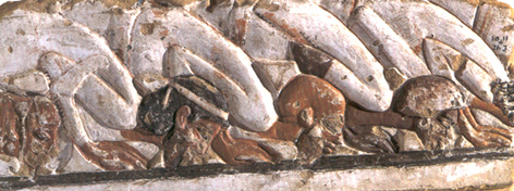
A row of tributaries bow to Amenhotep III from left to right--a Libyan, a Canaanite, a Syrian and a Nubian.
^ Note the complexion of the Libyan.
I don't discount the possibility of white Libyans, but I do have my suspicions since I see many Libyans with the exact same features and clothing as the white ones but with black skins. It makes me wonder whether folks are trying to revive the old 19th century theory of Petrie and Breasted's "white savages of North Africa".
Posts: 26238 | From: Atlanta, Georgia, USA | Registered: Feb 2005
| IP: Logged |


 UBBFriend: Email this page to someone!


![[Wink]](wink.gif) )
)
![[Big Grin]](biggrin.gif)


 Printer-friendly view of this topic