posted
The Periplus of the Erythraean Sea: Travel and Trade in the Indian Ocean by a Merchant of the First Century
A Sailing Manual:
The Periplus of the Erythraean Sea (Periplus Maris Erythraei) is a Greek periplus, describing navigation and trading opportunities from Roman Egyptian ports like Berenice along the coast of the Red Sea, and others along East Africa and India. Sometime in the middle of the first century AD, an anonymous merchant or sailor compiled a guidebook to the ports and sailing conditions of the Erythraean Sea. The Periplus Maris Erythraei (Guidebook of the Erythraean Sea) is the only document of its kind known to have survived. The author is unknown, it is clearly a firsthand description by someone familiar with the area, and is nearly unique in providing accurate insights into what the ancient world knew about the lands around the region. Erythraean Sea is the term applied by Greek and Roman geographers to the Indian Ocean, the Red Sea and the Persian Gulf.
---------------------------------------
1. Of the designated ports on the Erythraean Sea, and the market-towns around it, the first is the Egyptian port of Mussel Harbor. To those sailing down from that place, on the right hand, after eighteen hundred stadia, there is Berenice. The harbors of both are at the boundary of Egypt, and are bays opening from the Erythraean Sea.
2. On the right-hand coast next below Berenice is the country of the Berbers. Along the shore are the Fish-Eaters, living in scattered caves in the narrow valleys. Further inland are the Berbers, and beyond them the Wild-flesh-Eaters and Calf-Eaters, each tribe governed by its chief; and behind them, further inland, in the country towards the west, there lies a city called Meroe.
3. Below the Calf-Eaters there is a little market-town on the shore after sailing about four thousand stadia from Berenice, called Ptolemais of the Hunts, from which the hunters started for the interior under the dynasty of the Ptolemies. This market-town has the true land-tortoise in small quantity; it is white and smaller in the shells. And here also is found a little ivory like that of Adulis. But the place has no harbor and is reached only by small boats.
4. Below Ptolemais of the Hunts, at a distance of about three thousand stadia, there is Adulis, a port established by law, lying at the inner end of a bay that runs in toward the south. Before the harbor lies the so-called Mountain Island, about two hundred stadia seaward from the very head of the bay, with the shores of the mainland close to it on both sides. Ships bound for this port now anchor here because of attacks from the land. They used formerly to anchor at the very head of the bay, by an island called Diodorus, close to the shore, which could be reached on foot from the land; by which means the barbarous natives attacked the island. Opposite Mountain Island, on the mainland twenty stadia from shore, lies Adulis, a fair-sized village, from which there is a three-days' journey to Coloe, an inland town and the first market for ivory. From that place to the city of the people called Auxumites there is a five days' journey more; to that place all the ivory is brought from the country beyond the Nile through the district called Cyeneum, and thence to Adulis. Practically the whole number of elephants and rhinoceros that are killed live in the places inland, although at rare intervals they are hunted on the seacoast even near Adulis. Before the harbor of that market-town, out at sea on the right hand, there lie a great many little sandy islands called Alalaei, yielding tortoise-shell, which is brought to market there by the Fish-Eaters.
5. And about eight hundred stadia beyond there is another very deep bay, with a great mound of sand piled up at the right of the entrance; at the bottom of which the opsian stone is found, and this is the only place where it is produced. These places, from the Calf-Eaters to the other Berber country, are governed by Zoscales; who is miserly in his ways and always striving for more, but otherwise upright, and acquainted with Greek literature.
6. There are imported into these places, undressed cloth made in Egypt for the Berbers; robes from Arsinoe; cloaks of poor quality dyed in colors; double-fringed linen mantles; many articles of flint glass, and others of murrhine, made in Diospolis; and brass, which is used for ornament and in cut pieces instead of coin; sheets of soft copper, used for cooking-utensils and cut up for bracelets and anklets for the women; iron, which is made into spears used against the elephants and other wild beasts, and in their wars. Besides these, small axes are imported, and adzes and swords; copper drinking-cups, round and large; a little coin for those coming to the market; wine of Laodicea and Italy, not much; olive oil, not much; for the king, gold and silver plate made after the fashion of the country, and for clothing, military cloaks, and thin coats of skin, of no great value. Likewise from the district of Ariaca across this sea, there are imported Indian iron, and steel, and Indian cotton cloth; the broad cloth called monache and that called sagmatogene, and girdles, and coats of skin and mallow-colored cloth, and a few muslins, and colored lac. There are exported from these places ivory, and tortoiseshell and rhinoceros-horn. The most from Egypt is brought to this market from the month of January to September, that is, from Tybi to Thoth; but seasonably they put to sea about the month of September.
7. From this place the Arabian Gulf trends toward the east and becomes narrowest just before the Gulf of Avalites. After about four thousand stadia, for those sailing eastward along the same coast, there are other Berber market-towns, known as the 'far-side' ports; lying at intervals one after the other, without harbors but having roadsteads where ships can anchor and lie in good weather. The first is called Avalites; to this place the voyage from Arabia to the far-side coast is the shortest. Here there is a small market-town called Avalites, which must be reached by boats and rafts. There are imported into this place, flint glass, assorted; juice of sour grapes from Diospolis; dressed cloth, assorted, made for the Berbers; wheat, wine, and a little tin. There are exported from the same place, and sometimes by the Berbers themselves crossing on rafts to Ocelis and Muza on the opposite shore, spices, a little ivory, tortoise-shell, and a very little myrrh, but better than the rest. And the Berbers who live in the place are very unruly.
8. After Avalites there is another market-town, better than this, called Malao, distant a sail of about eight hundred stadia. The anchorage is an open roadstead, sheltered by a spit running out from the east. Here the natives are more peaceable. There are imported into this place the things already mentioned, and many tunics, cloaks from Arsinoe, dressed and dyed; drinking-cups, sheets of soft copper in small quantity, iron, and gold and silver coin, not much. There are exported from these places myrrh, a little frankincense, (that known as far-side), the harder cinnamon, duaca, Indian copal and macir, which are imported into Arabia; and slaves, but rarely.
9. Two days' sail, or three, beyond Malao is the market-town of Mundus, where the ships lie at anchor more safely behind a projecting island close to the shore. There are imported into this place the things previously set forth, and from it likewise are exported the merchandise already stated, and the incense called mocrotu. And the traders living here are more quarrelsome.
10. Beyond Mundus, sailing toward the east, after another two days' sail, or three, you reach Mosyllum, on a beach, with a bad anchorage. There are imported here the same things already mentioned, also silver plate, a very little iron, and glass. There are shipped from the place a great quantity of cinnamon, (so that this market-town requires ships of larger size), and fragrant gums, spices, a little tortoise shell, and mocrotu, (poorer, than that of Mundus), frankincense, (the far-side), ivory and myrrh in small quantities.
11. Sailing along the coast beyond Mosyllum, after a two days' course you come to the so-called Little Nile River, and a fine spring, and a small laurel-grove, and Cape Elephant. Then the shore recedes into a bay, and has a river, called Elephant, and a large laurel-grove called Acannae; where alone is produced the far-side frankincense, in great quantity and of the best grade.
12. Beyond this place, the coast trending toward the south, there is the Market and Cape of Spices, an abrupt promontory, at the very end of the Berber coast toward the east. The anchorage is dangerous at times from the ground-swell, because the place is exposed to the north. A sign of an approaching storm which is peculiar to the place, is that the deep water becomes more turbid and changes its color. When this happens they all run to a large promontory called Tabae, which offers safe shelter. There are imported into this market town the things already mentioned; and there are produced in it cinnamon (and its different varieties, gizir, asypha, areho, iriagia, and moto) and frankincense.
13. Beyond Tabae, after four hundred stadia, there is the village of Pano. And then, after sailing four hundred stadia along a promontory, toward which place the current also draws you, there is another market-town called Opone, into which the same things are imported as those already mentioned, and in it the greatest quantity of cinnamon is produced, (the arebo and moto), and slaves of the better sort, which are brought to Egypt in increasing numbers; and a great quantity of tortoise shell, better than that found elsewhere. [for Opone see map below]
14. The voyage to all these farside market-towns is made from Egypt about the month of July, that is Epiphi. And ships are also customarily fitted out from the places across this sea, from Ariaca and Barygaza, bringing to these far-side market-towns the products of their own places; wheat, rice, clarified butter, sesame oil, cotton cloth, (the monache and the sagmatogene), and girdles, and honey from the reed called sacchari. Some make the voyage especially to these market-towns, and others exchange their cargoes while sailing along the coast. This country is not subject to a King, but each market-town is ruled by its separate chief.
15. Beyond Opone, the shore trending more toward the south, first there are the small and great bluffs of Azania; this coast is destitute of harbors, but there are places where ships can lie at anchor, the shore being abrupt; and this course is of six days, the direction being south-west. Then come the small and great beach for another six days' course and after that in order, the Courses of Azania, the first being called Sarapion and the next Nicon; and after that several rivers and other anchorages, one after the other, separately a rest and a run for each day, seven in all, until the Pyralax islands and what is called the channel; beyond which, a little to the south of south-west, after two courses of a day and night along the Ausanitic coast, is the island Menuthias, about three hundred stadia from the mainland, low and and wooded, in which there are rivers and many kinds of birds and the mountain-tortoise. There are no wild beasts except the crocodiles; but there they do not attack men. In this place there are sewed boats, and canoes hollowed from single logs, which they use for fishing and catching tortoise. In this island they also catch them in a peculiar wav, in wicker baskets, which they fasten across the channel-opening between the breakers.
16. Two days' sail beyond, there lies the very last market-town of the continent of Azania, which is called Rhapta; which has its name from the sewed boats (rhapton ploiarion) already mentioned; in which there is ivory in great quantity, and tortoise-shell. Along this coast live men of piratical habits, very great in stature, and under separate chiefs for each place. The Mapharitic chief governs it under some ancient right that subjects it to the sovereignty of the state that is become first in Arabia. And the people of Muza now hold it under his authority, and send thither many large ships; using Arab captains and agents, who are familiar with the natives and intermarry with them, and who know the whole coast and understand the language.
17. There are imported into these markets the lances made at Muza especially for this trade, and hatchets and daggers and awls, and various kinds of glass; and at some places a little wine, and wheat, not for trade, but to serve for getting the good-will of the savages. There are exported from these places a great quantity of ivory, but inferior to that of Adulis, and rhinoceros-horn and tortoise-shell (which is in best demand after that from India), and a little palm-oil.
18. And these markets of Azania are the very last of the continent that stretches down on the right hand from Berenice; for beyong these places the unexplored ocean curves around toward the west, and running along by the regions to the south of Aethiopia and Libya and Africa, it mingles with the western sea.
19. Now to the left of Berenice, sailing for two or three days from Mussel Harbor eastward across the adjacent gulf, there is another harbor and fortified place, which is called White Village, from which there is a road to Petra, which is subject to Malichas, King of the Nabataeans. It holds the position of a market-town for the small vessels sent there from Arabia; and so a centurion is stationed there as a collector of one-fourth of the merchandise imported, with an armed force, as a garrison.
20. Directly below this place is the adjoining country of Arabia, in its length bordering a great distance on the Erythraean Sea. Different tribes inhabit the country, differing in their speech, some partially, and some altogether. The land next the sea is similarly dotted here and there with caves of the Fish-Eaters, but the country inland is peopled by rascally men speaking two languages, who live in villages and nomadic camps, by whom those sailing off the middle course are plundered, and those surviving shipwrecks are taken for slaves. And so they too are continually taken prisoners by the chiefs and kings of Arabia; and they are called Carnaites. Navigation is dangerous along this whole coast of Arabia, which is without harbors, with bad anchorages, foul, inaccessible because of breakers and rocks, and terrible in every way. Therefore we hold our course down the middle of the gulf and pass on as fast as possible by the country of Arabia until we come to the Burnt Island; directly below which there are regions of peaceful people, nomadic, pasturers of cattle, sheep and camels.
21. Beyond these places, in a bay at the foot of the left side of this gulf, there is a place by the shore called Muza, a market-town established by law, distant altogether from Berenice for those sailing southward, about twelve thousand stadia. And the whole place is crowded with Arab shipowners and seafaring men, and is busy with the affairs of commerce; for they carry on a trade with the far-side coast and with Barygaza, sending their own ships there.
22. Three days inland from this port there is a city called Saua, in the midst of the region called Mapharitis; and there is a vassal-chief named Cholaebus who lives in that city.
23. And after nine days more there is Saphar, the metropolis, in which lives Charibael, lawful king of two tribes, the Homerites and those living next to them, called the Sabaites; through continual embassies and gifts, he is a friend of the Emperors.
24. The market-town of Muza is without a harbor, but has a good roadstead and anchorage because of the sandy bottom thereabouts, where the anchors hold safely. The merchandise imported there consists of purple cloths, both fine and coarse; clothing in the Arabian style, with sleeves; plain, ordinary, embroidered, or interwoven with gold; saffron, sweet rush, muslins, cloaks, blankets (not many), some plain and others made in the local fashion; sashes of different colors, fragrant ointments in moderate quantity, wine and wheat, not much. For the country produces grain in moderate amount, and a great deal of wine. And to the King and the Chief are given horses and sumpter-mules, vessels of gold and polished silver, finely woven clothing and copper vessels. There are exported from the same place the things produced in the country: selected myrrh, and the Gebanite-Minaean stacte, alabaster and all the things already mentioned from Avalites and the far-side coast. The voyage to this place is made best about the month of September, that is Thoth; but there is nothing to prevent it even earlier.
25. After sailing beyond this place about three hundred stadia, the coast of Arabia and the Berber country about the Avalitic gulf now coming close together, there is a channel, not long in extent, which forces the sea together and shuts it into a narrow strait, the passage through which, sixty stadia in length, the island Diodorus divides. Therefore the course through it is beset with rushing currents and with strong winds blowing down from the adjacent ridge of mountains. Directly on this strait by the shore there is a village of Arabs, subject to the same chief, called Ocelis; which is not so much a market-town as it is an anchorage and watering-place and the first landing for those sailing into the gulf.
26. Beyond Ocelis, the sea widening again toward the east and soon giving a view of the open ocean, after about twelve hundred stadia there is Eudaemon Arabia, a village by the shore, also of the Kingdom of Charibael, and having convenient anchorages, and watering places, sweeter and better than those at Ocelis; it lies at the entrance of a bay, and the land recedes from it. It was called Eudaemon, because in the early days of the city when the voyage was not yet made from India to Egypt, and when they did not dare to sail from Egypt to the ports across this ocean, but all came together at this place, it received the cargoes from both countries, just as Alexandria now receives the things brought both from abroad and from Egypt. But not long before our own time Charibael destroyed the place.
27. After Eudaemon Arabia there is a continuous length of coast, and a bay extending two thousand stadia or more, along which there are Nomads and Fish-Eaters living in villages; just beyond the cape projecting from this bay there is another market-town by the shore, Cana, of the Kingdom of Eleazus, the Frankincense Country; and facing it there are two desert islands, one called Island of Birds, the other Dome Island, one hundred and twenty stadia from Cana. Inland from this place lies the metropolis Sabbatha, in which the King lives. All the frankincense produced in the country is brought by camels to that place to be stored, and to Cana on rafts held up by inflated skins after the manner of the country, and in boats. And this place has a trade also with the far-side ports, with Barygaza. and Scythia and Ommana and the neighboring coast of Persia.
28. There are imported into this place from Egypt a little wheat and wine, as at Muza; clothing in the Arabian style, plain and common and most of it spurious; and copper and tin and coral and storax and other things such as go to Muza; and for the King usually wrought gold and silver plate, also horses, images, and thin clothing of fine quality. And there are exported from this place, native produce, frankincense and aloes, and the rest of the things that enter into the trade of the other ports. The voyage to this place is best made at the same time as that to Muza, or rather earlier.
29. Beyond Cana, the land receding greatly, there follows a very deep bay stretching a great way across, which is called Sachalites; and the Frankincense Country, mountainous and forbidding, wrapped in thick clouds and fog, and yielding frankincense from the trees. These incense-bearing trees are not of great height or thickness; they bear the frankincense sticking in drops on the bark, just as the trees among us in Egypt weep their gum. The frankincense is gathered by the King's slaves and those who are sent to this service for punishment. For these places are very unhealthy, and pestilential even to those sailing along the coast; but almost always fatal to those working there, who also perish often from want of food.
30. On this bay there is a very great promontory facing the east, called Syagrus; on which is a fort for the defence of the country, and a harbor and storehouse for the frankincense that is collected; and opposite this cape, well out at sea, there is an island, lying between it and the Cape of Spices opposite, but nearer Syagrus: it is called Dioscorida, and is very large but desert and marshy, having rivers in it and crocodiles and many snakes and great lizards, of which the flesh is eaten and the fat melted and used instead of olive oil. The island yields no fruit, neither vine nor grain. The inhabitants are few and they live on the coast toward the north, which from this side faces the continent. They are foreigners, a mixture of Arabs and Indians and Greeks, who have emigrated to carry on trade there. The island produces the true sea-tortoise, and the land-tortoise, and the white tortoise which is very numerous and preferred for its large shells; and the mountain-tortoise, which is largest of all and has the thickest shell; of which the worthless specimens cannot be cut apart on the under side, because they are even too hard; but those of value are cut apart and the shells made whole into caskets and small plates and cake-dishes and that sort of ware. There is also produced in this island cinnabar, that called Indian, which is collected in drops from the trees.
31. It happens that just as Azania is subject to Charibael and the Chief of Mapharitis, this island is subject to the King of the Frankincense Country. Trade is also carried on there by some people from Muza and by those who chance to call there on the voyage from Damirica and Barygaza; they bring in rice and wheat and Indian cloth, and a few female slaves; and they take for their exchange cargoes, a great quantity of tortoise-shell. Now the island is farmed out under the Kings and is garrisoned.
32. Immediately beyond Syagrus the bay of Omana cuts deep into the coast-line, the width of it being six hundred stadia; and beyond this there are mountains, high and rocky and steep, inhabited by cave-dwellers for five hundred stadia more; and beyond this is a port established for receiving the Sachalitic frankincense; the harbor is called Moscha, and ships from Cana call there regularly; and ships returning from Damirica and Barygaza, if the season is late, winter there, and trade with the King's officers, exchanging their cloth and wheat and sesame oil for frankincense, which lies in heaps all over the Sachalitic country, open and unguarded, as if the place were under the protection of the gods; for neither openly nor by stealth can it be loaded on board ship without the King's permission; if a single grain were loaded without this, the ship could not clear from the harbor.
33. Beyond the harbor of Moscha for about fifteen hundred stadia as far as Asich, a mountain range runs along the shore; at the end of which, in a row, lie seven islands, called Zenobian. Beyond these there is a barbarous region which is no longer of the same Kingdom, but now belongs to Persia. Sailing along this coast well out at sea for two thousand stadia from the Zenobian Islands, there meets you an island called Sarapis, about one hundred and twenty stadia from the mainland. It is about two hundred stadia wide and six hundred long, inhabited by three settlements of Fish-Eaters, a villainous lot, who use the Arabian language and wear girdles of palm-leaves. The island produces considerable tortoise-shell of fine quality, and small sailboats and cargo-ships are sent there regularly from Cana.
34. Sailing along the coast, which trends northward toward the entrance of the Persian Sea, there are many islands known as the Calxi, after about two thousand stadia, extending along the shore. The inhabitants are a treacherous lot, very little civilized.
35. At the upper end of these Calaei islands is a range of mountains called Calon, and there follows not far beyond, the mouth of the Persian Gulf, where there is much diving for the pearl-mussel. To the left of the straits are great mountains called Asabon, and to the right there rises in full view another round and high mountain called Semiramis; between them the passage across the strait is about six hundred stadia; beyond which that very great and broad sea, the Persian Gulf, reaches far into the interior. At the upper end of this Gulf there is a market-town designated by law called Apologus, situated near Charax Spasini and the River Euphrates.
36. Sailing through the mouth of the Gulf, after a six-days' course there is another market-town of Persia called Ommana. To both of these market-towns large vessels are regularly sent from Barygaza, loaded with copper and sandalwood and timbers of teakwood and logs of blackwood and ebony. To Ommana frankincense is also brought from Cana, and from Ommana to Arabia boats sewed together after the fashion of the place; these are known as madarata. From each of these market-towns, there are exported to Barygaza and also to Arabia, many pearls, but inferior to those of lndia; purple, clothing after the fashion of the place, wine, a great quantity of dates, gold and slaves.
37. Beyond the Ommanitic region there is a country also of the Parsids, of another Kingdom, and the bay of Gedrosia, from the middle of which a cape juts out into the bay. Here there is a river affording an entrance for ships, with a little market-town at the mouth, called Oraea; and back from the place an inland city, distant a seven days' journey from the sea, in which also is the King's court; it is called ----- (probably Rhambacia). This country yields much, wheat, wine, rice and dates; but along the coast there is nothing but bdellium.
38. Beyond this region, the continent making a wide curve from the east across the depths of the bays, there follows the coast district of Scythia, which lies above toward the north; the whole marshy; from which flows down the river Sinthus, the greatest of all the rivers that flow into the Erythraean Sea, bringing down an enormous volume of water; so that a long. way out at sea, before reaching this country, the water of the ocean is fresh from it. Now as a sign of approach to this country to those coming from the sea, there are serpents coming forth from the depths to meet you; and a sign of the places just mentioned and in Persia, are those called graoe. This river has seven mouths, very shallow and marshy, so that they are not navigable, except the one in the middle; at which by the shore, is the market-town, Barbaricum. Before it there lies a small island, and inland behind it is the metropolis of Scythia, Minnagara; it is subject to Parthian princes who are constantly driving each other out.
39. The ships lie at anchor at Barbaricum, but all their cargoes are carried up to the metropolis by the river, to the King. There are imported into this market a great deal of thin clothing, and a little spurious; figured linens, topaz, coral, storax, frankincense, vessels of glass, silver and gold plate, and a little wine. On the other hand there are exported costus, bdellium, lycium, nard, turquoise, lapis lazuli, Seric skins, cotton cloth, silk yarn, and indigo. And sailors set out thither with the Indian Etesian winds, about the, month of July, that is Epiphi: it is more dangerous then, but through these winds the voyage is more direct, and sooner completed.
40. Beyond the river Sinthus there is another gulf, not navigable, running in toward the north; it is called Eirinon; its parts are called separately the small gulf and the great; in both parts the water is shallow, with shifting sandbanks occurring continually and a great way from shore; so that very often when the shore is not even in sight, ships run aground, and if they attempt to hold their course they are wrecked. A promontory stands out from this gulf, curving around from Eirinon toward the East, then South, then West, and enclosing the gulf called Baraca, which contains seven islands. Those who come to the entrance of this bay escape it by putting about a little and standing further out to sea; but those who are drawn inside into the gulf of Baraca are lost; for the waves are high and very violent, and the sea is tumultuous and foul, and has eddies and rushing whirlpools. The bottom is in some places abrupt, and in others rocky and sharp, so that the anchors lying there are parted, some being quickly cut off, and others chafing on the bottom. As a sign of these places to those approaching from the sea there are serpents, very large and black; for at the other places on this coast and around Barygazal, they are smaller, and in color bright green, running into gold.
41. Beyond the gulf of Baraca is that of Barygaza and the coast of the country of Ariaca, which is the beginning of the Kingdom of Nambanus and of all India. That part of it lying inland and adjoining Scythia is called Abiria, but the coast is called Syrastrene. It is a fertile country, yielding wheat and rice and sesame oil and clarified butter, cotton and the Indian cloths made therefrom, of the coarser sorts. Very many cattle are pastured there, and the men are of great stature and black in color. The metropolis of this country is Minnagara, from which much cotton cloth is brought down to Barygaza. In these places there remain even to the present time signs of the expedition of Alexander, such as ancient shrines, walls of forts and great wells. The sailing course along this coast, from Barbaricum to the promontory called Papica opposite Barygaza, and before Astacampra, is of three thousand stadia.
42. Beyond this there is another gulf exposed to the sea-waves, running up toward the north, at the mouth of which there is an island called Baeones; at its innermost part there is a great river called Mais. Those sailing to Barygaza pass across this gulf, which is three hundred stadia in width, leaving behind to their left the island just visible from their tops toward the east, straight to the very mouth of the river of Barygaza; and this river is called Nammadus.
43. This gulf is very narrow to Barygaza and very hard to navigate for those coming from the ocean; this is the case with both the right and left passages, but there is a better passage through the left. For on the right at the very mouth of the gulf there lies a shoal, long and narrow, and full of rocks, called Herone, facing the village of Cammoni; and opposite this on the left projects the promontory that lies before Astacampra, which is called Papica, and is a bad anchorage because of the strong current setting in around it and because the anchors are cut off, the bottom being rough and rocky. And even if the entrance to the gulf is made safely, the mouth of the river at Barygaza is found with difficulty, because the shore is very low and cannot be made out until you are close upon it. And when, you have found it the passage is difficult because of the shoals at the mouth of the river.
44. Because of this, native fishermen in the King's service, stationed at the very entrance in well-manned large boats called tappaga and cotymba, go up the coast as far as Syrastrene, from which they pilot vessels to Barygaza. And they steer them straight from the mouth of the bay between the shoals with their crews; and they tow them to fixed stations, going up with the beginning of the flood, and lying through the ebb at anchorages and in basins. These basins are deeper places in the river as far as Barygaza; which lies by the river, about three hundred stadia up from the mouth.
45. Now the whole country of India has very many rivers, and very great ebb and flow of the tides; increasing at the new moon, and at the full moon for three days, and falling off during the intervening days of the moon. But about Barygaza it is much greater, so that the bottom is suddenly seen, and now parts of the dry land are sea, and now it is dry where ships were sailing just before; and the rivers, under the inrush of the flood tide, when the whole force of the sea is directed against them, are driven upwards more strongly against their natural current, for many stadia.
46. For this reason entrance and departure of vessels is very dangerous to those who are inexperienced or who come to this market-town for the first time. For the rush of waters at the incoming tide is irresistible, and the anchors cannot hold against it; so that large ships are caught up by the force of it, turned broadside on through the speed of the current, and so driven on the shoals and wrecked; and smaller boats are overturned; and those that have been turned aside among the channels by the receding waters at the ebb, are left on their sides, and if not held on an even keel by props, the flood tide comes upon them suddenly and under the first head of the current they are filled with water. For there is so great force in the rush of the sea at the new moon, especially during the flood tide at night, that if you begin the entrance at the moment when the waters are still, on the instant there is borne to you at the mouth of the river, a noise like the cries of an army heard from afar; and very soon the sea itself comes rushing in over the shoals with a hoarse roar.
47. The country inland from Barygaza is inhabited by numerous tribes, such as the Arattii, the Arachosii, the Gandaraei and the people of Poclais, in which is Bucephalus Alexandria. Above these is the very warlike nation of the Bactrians, who are under their own king. And Alexander, setting out from these parts, penetrated to the Ganges, leaving aside Damirica and the southern part of India; and to the present day ancient drachmae are current in Barygaza, coming from this country, bearing inscriptions in Greek letters, and the devices of those who reigned after Alexander, Apollodorus and Menander.
48. Inland from this place and to the east, is the city called Ozene, formerly a royal capital; from this place are brought down all things needed for the welfare of the country about Barygaza, and many things for our trade: agate and carnelian, Indian muslins and mallow cloth, and much ordinary cloth. Through this same region and from the upper country is brought the spikenard that comes through Poclais; that is, the Caspapyrene and Paropanisene and Cabolitic and that brought through the adjoining country of Scythia; also costus and bdellium.
49. There are imported into this market-town, wine, Italian preferred, also Laodicean and Arabian; copper, tin, and lead; coral and topaz; thin clothing and inferior sorts of all kinds; bright-colored girdles a cubit wide; storax, sweet clover, flint glass, realgar, antimony, gold and silver coin, on which there is a profit when exchanged for the money of the country; and ointment, but not very costly and not much. And for the King there are brought into those places very costly vessels of silver, singing boys, beautiful maidens for the harem, fine wines, thin clothing of the finest weaves, and the choicest ointments. There are exported from these places spikenard, costus, bdellium, ivory, agate and carnelian, lycium, cotton cloth of all kinds, silk cloth, mallow cloth, yarn, long pepper and such other things as are brought here from the various market-towns. Those bound for this market-town from Egypt make the voyage favorably about the month of July, that is Epiphi.
50. Beyond Barygaza the adjoining coast extends in a straight line from north to south; and so this region is called Dachinabades, for dachanos in the language of the natives means 'south.' The inland country back from the coast toward the east comprises many desert regions and great mountains; and all kinds of wild beasts -- leopards, tigers, elephants, enormous serpents, hyenas, and baboons of many sorts; and many populous nations, as far as the Ganges.
51. Among the market-towns of Dachinabades there are two of special importance; Paethana, distant about twenty days' journey south from Barygaza; beyond which, about ten days' journey east, there is another very great city, Tagara. There are brought down to Barygaza from these places by wagons and through great tracts without roads, from Paethana carnelian in great quantity, and from Tagara much common cloth, all kinds of muslins and mallow cloth, and other merchandise brought there locally from the regions along the sea-coast. And the whole course to the end of Damirica is seven thousand stadia; but the distance is greater to the Coast Country.
52. The market-towns of this region are, in order, after Barygaza: Suppara, and the city of Calliena, which in the time of the elder Saraganus became a lawful market-town; but since it came into the possession of Sandares the port is much obstructed, and Greek ships landing there may chance to be taken to Barygaza under guard.
53. Beyond Calliena there are other market-towns of this region; Semylla, Mandagora, Palaepatmoe, Melizigara, Byzantium, Togarum and Aurannoboas. Then there are the islands called Sesecrienae and that of the Aegidii, and that of the Caenitae, opposite the place called Chersonesus (and in these places there are pirates), and after this the White Island. Then come Naura and Tyndis, the first markets of Damirica, and then Muziris and Nelcynda, which are now of leading importance.
54. Tyndis is of the Kingdom of Cerobothra; it is a village in plain sight by the sea. Muziris, of the same kingdom, abounds in ships sent there with cargoes from Arabia, and by the Greeks; it is located on a river, distant from Tyndis by river and sea five hundred stadia, and up the river from the shore twenty stadia. Nelcynda is distant from Muziris by river and sea about five hundred stadia, and is of another Kingdom, the Pandian. This place also is situated on a river, about one hundred and twenty stadia from the sea.
55. There is another place at the mouth of this river, the village of Bacare, to which ships drop down on the outward voyage from Nelcynda, and anchor in the roadstead to take on their cargoes; because the river is full of shoals and the channels are not clear. The kings of both these market-towns live in the interior. And as a sign to those approaching these places from the sea there are serpents coming forth to meet you, black in color, but shorter, like snakes in the head, and with blood-red eyes.
56. They send large ships to these market-towns on account of the great quantity and bulk of pepper and malabathrum. There are imported here, in the first place, a great quantity of coin; topaz, thin clothing, not much; figured linens, antimony, coral, crude glass, copper, tin, lead; wine, not much, but as much as at Barygaza; realgar and orpiment; and wheat enough for the sailors, for this is not dealt in by the merchants there. There is exported pepper, which is produced in quantity in only one region near these markets, a district called Cottonara. Besides this there are exported great quantities of fine pearls, ivory, silk cloth, spikenard from the Ganges, malabathrum from the places in the interior, transparent stones of' all kinds, diamonds and sapphires, and tortoise-shell; that from Chryse Island, and that taken among the islands along the coast of Damirica. They make the voyage to this place in a favorable season who set out from Egypt about the month of July, that is Epiphi.
57. This whole voyage as above described, from Cana and Eudaemon Arabia, they used to make in small vessels, sailing close around the shores of the gulfs; and Hippalus was the pilot who by observing the location of the ports and the conditions of the sea, first discovered how to lay his course straight across the ocean. For at the same time when with us the Etesian winds are blowing, on the shores of India the wind sets in from the ocean, and this southwest wind is called Hippalus, from the name of him who first discovered the passage across. From that time to the present day ships start, some direct from Cana, and some from the Cape of Spices; and those bound for Damirica throw the shlp's head considerably off the wind; while those bound for Barygaza and Scythia keep along shore not more than three days and for the rest of the time hold the same course straight out to sea from that region, with a favorable wind, quite away from the land, and so sail outside past the aforesaid gulfs.
58. Beyond Bacare there is the Dark Red Mountain, and another district stretching along the coast toward the south, called Paralia. The first place is called Balita; it has a fine harbor and a village by the shore. Beyond this there is another place called Comari, at which are the Cape of Comari and a harbor; hither come those men who wish to consecrate themselves for the rest of their lives, and bathe and dwell in celibacy; and women also do the same; for it is told that a goddess once dwelt here and bathed.
59. From Comari toward the south this region extends to Colchi, where the pearl-fisheries are; (they are worked by condemned criminals); and it belongs to the Pandian Kingdom. Beyond Colchi there follows another district called the Coast Country, which lies on a bay, and has a region inland called Argaru. At this place, and nowhere else, are bought the pearls gathered on the coast thereabouts; and from there are exported muslins, those called Argaritic.
60. Among the market-towns of these countries, and the harbors where the ships put in from Damirica and from the north, the most important are, in order as they lie, first Camara, then Poduca, then Sopatma; in which there are ships of the country coasting along the shore as far as Damirica; and other very large vessels made of single logs bound together, called sangara; but those which make the voyage to Chryse and to the Ganges are called colandia, and are very large. There are imported into these places everything made in Damirica, and the greatest part of what is brought at any time from Egypt comes here, together with most kinds of all the things that are brought from Damirica and of those that are carried through Paralia.
61. About the following region, the course trending toward the east, lying out at sea toward the west is the island Palaesimundu, called by the ancients Taprobane. The northern part is a day's journey distant, and the southern part trends gradually toward the west, and almost touches the opposite shore of Azania. It produces pearls, transparent stones, muslins, and tortoise-shell.
62. About these places is the region of Masalia stretching a great way along the coast before the inland country; a great quantity of muslins is made there. Beyond this region, sailing toward the cast and crossing the adjacent bay, there is the region of Dosarene, yielding the ivory known as Dosarenic. Beyond this, the course trending toward the north, there are many barbarous tribes, among whom are the Cirrhadae, a race of men with flattened noses, very savage; another tribe, the Bargysi; and the Horse-faces and the Long-faces, who are said to be cannibals.
63. After these, the course turns toward the east again, and sailing with the ocean to the right and the shore remaining beyond to the left, Ganges comes into view, and near it the very last land toward the east, Chryse. There is a river near it called the Ganges, and it rises and falls in the same way as the Nile. On its bank is a market-town which has the same name as the river, Ganges. Through this place are brought malabathrum and Gangetic spikenard and pearls, and rnuslins of the finest sorts, which are called Gangetic. It is said that there are gold-mines near these places, and there is a gold coin which is called caltis. And just opposite this river there is an island in the ocean, the last part of the inhabited world toward the cast, under the rising sun itself; it is called Chryse; and it has the best tortoise-shell of all the places on the Erythraean Sea.
64. After this region under the very north, the sea outside ending in a land called This, there is a very great inland city called Thinae, from which raw silk and silk yarn and silk cloth are brought on foot through Bactria to Barygaza, and are also exported to Damirica by way of the river Ganges. But the land of This is not easy of access; few men come from there, and seldom. The country lies under the Lesser Bear, and is said to border on the farthest parts of Pontus and the Caspian Sea, next to which lies Lake Maeotis; all of which empty into the ocean.
65. Every year on the borders of the land of This there comes together a tribe of men with short bodies and broad, flat faces, and by nature peaceable; they are called Besatae, and are almost entirely uncivilized. They come with their wives and children, carrying great packs and plaited baskets of what looks like green grape-leaves. They meet in a place between their own country and the land of This. There they hold a feast for several days, spreading out the baskets under themselves as mats, and then return to their own places in the interior. And then the natives watching them come into that place and gather up their mats; and they pick out from the braids the fibers which they call petri. They lay the leaves closely together in several layers and make them into balls, which they pierce with the fibers from the mats. And there are three sorts; those made of the largest leaves are called the large-ball malabathrum; those of the smaller, the medium-ball; and those of the smallest, the small-ball. Thus there exist three sorts of malabathrum, and it is brought into India by those who prepare it.
66. The regions beyond these places are either difficult of access because of their excessive winters and great cold, or else cannot be sought out because, of some divine influence of the gods.
Source:
W.H. Schoff (tr. & ed.), The Periplus of the Erythraean Sea: Travel and Trade in the Indian Ocean by a Merchant of the First Century (London, Bombay & Calcutta 1912).
Posts: 1549 | From: California, USA | Registered: Jan 2006
| IP: Logged |
quote:16. Two days' sail beyond, there lies the very last market-town of the continent of Azania, which is called Rhapta; which has its name from the sewed boats (rhapton ploiarion) already mentioned; in which there is ivory in great quantity, and tortoise-shell. Along this coast live men of piratical habits, very great in stature, and under separate chiefs for each place. The Mapharitic chief governs it under some ancient right that subjects it to the sovereignty of the state that is become first in Arabia. And the people of Muza now hold it under his authority, and send thither many large ships; using Arab captains and agents, who are familiar with the natives and intermarry with them, and who know the whole coast and understand the language.
17. There are imported into these markets the lances made at Muza especially for this trade, and hatchets and daggers and awls, and various kinds of glass; and at some places a little wine, and wheat, not for trade, but to serve for getting the good-will of the savages. There are exported from these places a great quantity of ivory, but inferior to that of Adulis, and rhinoceros-horn and tortoise-shell (which is in best demand after that from India), and a little palm-oil.
18. And these markets of Azania are the very last of the continent that stretches down on the right hand from Berenice; for beyong these places the unexplored ocean curves around toward the west, and running along by the regions to the south of Aethiopia and Libya and Africa, it mingles with the western sea
Myra thanks for posting this. A African archaeologist named Felix Chami has proven that the people of Rhapta and Azania were the ancestors of the Swahili people. He proved that they were Bantu speaking people instead of foreigners. Evidence shows that while the Arabs did intermarry and assimilate the culture and people were 100% African in origin.
The Berbers mentioned in the texts are most likely the ancestors of the Cushic people.[Somalis,Oromos,etc..]
Here is some more information for you about Rhapta and the archaeological work of Dr. Felix Chami:
Wednesday, 17 April, 2002, 17:27 GMT 18:27 UK Tanzanian dig unearths ancient secret
The Swahili people have been viewed as of Persian/Arabic or Cushitic speaking origin. Scholars have used historical and archaeological data to support this hypothesis. However, linguistic and recent archaeological data suggest the Swahili culture had its origins in the early first centuries A.D. it was the early farming people who settled on the coast in the last centuries B.C. who first adopted iron technology and sailing techniques and founded the coastal settlements. the culture of iron-using people spread to the rest of the coast of East Africa, its center changing fom one place to another. Involvements in transoceanic trade from the early centuries A.D. contributed to the prosperity of the coastal communities as evidenced by coastal monuments. More than 1500 years of cultural continuity was offset by the arrival of European and Arab colonizers in the seventeenth and nineteenth centuries A.D.
African Archaeological Review
16 (3): 199-218, September 1998
Felix Chami
African Archaeological Review 20 (2): 65-80, June 2003 Neolithic Pottery Traditions from the Islands, the Coast and the Interior of East Africa Felix Chami
Amandus Kwekason
Abstract
Scholars have attributed the spread of agriculture and pottery technology to the larger part of eastern and southern Africa to Bantu speakers. However, the spread of similar aspects to the Kenya and Tanzania Rift Valley as far south as Eyasi Basin and as far east as Mount Kilimanjaro has been attributed to Cushitic speakers. Whereas the spread of these innovations to the Rift Valley region can be dated to 3000 B.C., the remaining part of eastern and southern Africa is alleged to have received similar innovations only after the BC/AD changeover, when iron technology was introduced. These theories can no longer be sustained. The coast of Tanzania, its immediate hinterland, and the deep islands of Zanzibar and Mafia were settled by people who had knowledge of agriculture and pottery making probably before 3000 B.C. These innovations are also found to have spread to southern Africa in the last millennium B.C. The introduction of iron technology and beveled/fluted pottery, associated with Bantu speakers, was just another stage in the cultural evolution of the people of eastern and southern Africa, but not the beginning of settled, farming/domesticating communities.
CHAMI, Dr. Felix A.
The Graeco-Romans and Paanchea/Azania: sailing in the Erythraean Sea
quote:The Berbers mentioned in the texts are most likely the ancestors of the Cushic people.[Somalis,Oromos,etc.]
Good point and this is why we have to be careful when reading the ancient texts, and place into context what the ancients were trying to describe.
My position on Berber is that it is, at root, only and African language group, and the moment we try to make it into anything else, the concept falls apart.
Posts: 15202 | Registered: Jun 2004
| IP: Logged |
quote:The Berbers mentioned in the texts are most likely the ancestors of the Cushic people.[Somalis,Oromos,etc.]
Good point and this is why we have to be careful when reading the ancient texts, and place into context what the ancients were trying to describe.
My position on Berber is that it is, at root, only and African language group, and the moment we try to make it into anything else, the concept falls apart.
Wouldn't it be wonderful if some other sensible term was given to the language family name that is now referred to as "Berber". But I suppose, since this name has been corrupted from a historical context(s), and attained a widespread use within the circles of Euro-scholars, and adopted by yet other folks, it won't be an easy one to let go off. Like the term "Nubia", "Berber" has had its fair share of confusing various folks. Just look at "Nubia"; the term "Nubia" is persistently, and in some cases knowingly, used erroneously in the historical reconstructions of the Nile Valley, when it really has nothing to do with the way the ancient Nile Valley folks perceived themselves. I suspect this to be the case with the ancestors of the diverse groups, whose language is now lumped into the "Berber" language family.
Posts: 1947 | Registered: Sep 2005
| IP: Logged |
quote:The Berbers mentioned in the texts are most likely the ancestors of the Cushic people.[Somalis,Oromos,etc.]
Good point and this is why we have to be careful when reading the ancient texts, and place into context what the ancients were trying to describe.
My position on Berber is that it is, at root, only and African language group, and the moment we try to make it into anything else, the concept falls apart.
Hey Rasol. I just wanted to know, did you get my private message?
Thanx.
Posts: 1203 | From: USA | Registered: Feb 2005
| IP: Logged |
posted
The Indian Ocean Slave trade evolved around the Indian Ocean basin. Slaves were taken from mainland East Africa and sold in markets in the Arabian Peninsula and the Persian Gulf. In contrast to the trans-Atlantic Slave Trade, the Indian Ocean Slave Trade was much older dating back from at least the second century C.E. until the early twentieth century. For example, the oldest written document from the East Africa Coast, the Periplus of the Erythraean Sea, describes a small trade in slaves around the second century C.E.
Group of Slaves with Arab men Zanzibar, 1850-1890
Posts: 1549 | From: California, USA | Registered: Jan 2006
| IP: Logged |
quote:Originally posted by ausar: Myra thanks for posting this. A African archaeologist named Felix Chami has proven that the people of Rhapta and Azania were the ancestors of the Swahili people. He proved that they were Bantu speaking people instead of foreigners. Evidence shows that while the Arabs did intermarry and assimilate the culture and people were 100% African in origin.
The Berbers mentioned in the texts are most likely the ancestors of the Cushic people.[Somalis,Oromos,etc..]
Here is some more information for you about Rhapta and the archaeological work of Dr. Felix Chami:
Wednesday, 17 April, 2002, 17:27 GMT 18:27 UK Tanzanian dig unearths ancient secret
The Swahili people have been viewed as of Persian/Arabic or Cushitic speaking origin. Scholars have used historical and archaeological data to support this hypothesis. However, linguistic and recent archaeological data suggest the Swahili culture had its origins in the early first centuries A.D. it was the early farming people who settled on the coast in the last centuries B.C. who first adopted iron technology and sailing techniques and founded the coastal settlements. the culture of iron-using people spread to the rest of the coast of East Africa, its center changing fom one place to another. Involvements in transoceanic trade from the early centuries A.D. contributed to the prosperity of the coastal communities as evidenced by coastal monuments. More than 1500 years of cultural continuity was offset by the arrival of European and Arab colonizers in the seventeenth and nineteenth centuries A.D.
African Archaeological Review
16 (3): 199-218, September 1998
Felix Chami
African Archaeological Review 20 (2): 65-80, June 2003 Neolithic Pottery Traditions from the Islands, the Coast and the Interior of East Africa Felix Chami
Amandus Kwekason
Abstract
Scholars have attributed the spread of agriculture and pottery technology to the larger part of eastern and southern Africa to Bantu speakers. However, the spread of similar aspects to the Kenya and Tanzania Rift Valley as far south as Eyasi Basin and as far east as Mount Kilimanjaro has been attributed to Cushitic speakers. Whereas the spread of these innovations to the Rift Valley region can be dated to 3000 B.C., the remaining part of eastern and southern Africa is alleged to have received similar innovations only after the BC/AD changeover, when iron technology was introduced. These theories can no longer be sustained. The coast of Tanzania, its immediate hinterland, and the deep islands of Zanzibar and Mafia were settled by people who had knowledge of agriculture and pottery making probably before 3000 B.C. These innovations are also found to have spread to southern Africa in the last millennium B.C. The introduction of iron technology and beveled/fluted pottery, associated with Bantu speakers, was just another stage in the cultural evolution of the people of eastern and southern Africa, but not the beginning of settled, farming/domesticating communities.
CHAMI, Dr. Felix A.
The Graeco-Romans and Paanchea/Azania: sailing in the Erythraean Sea
posted
1851 Hand Colored Stone Lithograph: Characters, Costumes, and Modes of Life, in the Valley of the Nile
First photo: Cairine lady waited upon by a Galla [Oromo] slave girl, Prisse D'Avennes, 1807-1879, artist, Printed on image: Drawn by E. Prisse. On stone by Mouilleron. Printed on verso: Exhibition--Arabs. Plate from the book: The Valley of the Nile, James Madden, London, 1851.
Second Photo: Habesh, or, Abysinnian slave, Cairo. Prisse D'Avennes, 1807-1879, artist Printed by Le[m]ercier, Paris. Printed on verso: "Exhibits--Egypt: Modern: set." Plate from the book: The Valley of the Nile, James Madden, London, 1851. Original: color lithograph.
Description: 1851 Hand Colored Stone Lithograph: Characters, Costumes, and Modes of Life, in the Valley of the Nile. James Madden, London, 1851 Illustrated from the designs taken on the spot, by Emile Prisse. Prisse worked in Egypt, documenting the land and its inhabitants. He provided institutions with a very rich documentation of pre-modern Egypt. He was also one of the first people to realize the importance of the preservation and protection of ancient artifacts and monuments Prisse's original drawings were redrawn onto stone and published by James Madden.
Posts: 1549 | From: California, USA | Registered: Jan 2006
| IP: Logged |
posted
What about the Third photo of the Ethiopian male? What is supposed to be understood about this person?
Posts: 1947 | Registered: Sep 2005
| IP: Logged |
posted
In the 1970s Tor Heyerdahl built the reed boat Tigris to try to show that sailors already about 4000 years ago could sail from Mesopotamia to the Indus valley and from there to the Red Sea and Egypt on trading expeditions. With Tigris Heyerdahl and his crew sailed from Iraq to Karachi in Pakistan, and from there to Djibouti. They aimed to sail into the Red Sea and to Egypt but because of the political situation they could not complete the mission. As a protest against the unrest in the area Heyerdahl and the crew burned Tigris in 1978.
posted
^ How can we forget?! Heyerdahl was one of the pioneers in ancient maritime reconstruction which corroborates ancient texts and archaeology on Bronze Age maritime trade.
quote:Originally posted by BrandonP: Consider the recent report of Egyptian mummification ingredients coming from Southeast Asia, this is likely the case!
Yes, I've read about that finding. Recall that in my thread I cited a paper showing how some ancient Chinese bronzes were imports from East Africa.
But it's funny you should cite the Southeast Asian products. Southeast Asia is often ignored when it comes to ancient history let alone ancient global trade with the West.
The Greco-Romans knew of Southeast Asia as "Chryser Khora" (Golden Land) or "Chryser Nesoi" (Golden Islands). Only a few scholars like Dr. Stephen Oppenheimer and Dr. Wilhelm Solheim have shown how significant Austronesian speakers were in the development of civilization and trade in the region and of course independent Filipino scholar Paul Kekai Manansala with his work below.
Posts: 26246 | From: Atlanta, Georgia, USA | Registered: Feb 2005
| IP: Logged |
posted
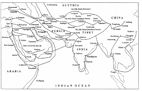
Rome's Eastern Trade Writing in the third quarter of the first century CE, the Roman author Pliny complained: "At the smallest reckoning 100 million sesterces [of gold=16,660 English pounds] is the sum which every year India, the silk-growing country of northern China, and the Arabian peninsula take from our Empire. Such is the cost to us of our exquisites and our women." Whether in fact the Roman Empire was being bankrupted by female tastes for luxury, its eastern trade was significant. Indeed this was precisely the period when the Han Empire had been aggressively expanding into Central Asia and when huge quantities of Chinese silk were being shipped westwards.
There were several routes to the East. In the north, trade passed through the Caucasus, crossed the Caspian Sea and then went up the Amu Darya (Oxus) river. Of much greater significance was the route from the Mediterranean through Damascus and the desert city of Palmyra to Mesopotamia. From there, merchants either could sail down to the Persian Gulf or head northeast through Parthia to Central Asia. A Macedonian merchant Maes Titianus described this route up to an inner Asian location known as the Stone Tower, where the exchange of goods would take place with merchants coming from China. The third of the routes was via the Red Sea and on to India. On the western end of this route, the trade could go up through Petra (in today's Jordan) to Syria or directly across to the Mediterranean. Alternatively, merchants crossed from the Red Sea to the Nile and on to the great city of Alexandria.
The sea route to India really opened up in the first century BCE with the discovery of how the monsoon winds would allow direct passage across the Indian Ocean and back, thus avoiding the coastal route with its dangerous reefs and pirates. The classic description of these sea routes is a book written in the first century CE, the Periplus of the Erythraean (Red) Sea. Its author was at least vaguely aware of China: "...Somewhere on the outer fringe, there is a very great inland city called Thina from which silk floss, yarn and cloth are shipped by land via Bactria to Barygaza [i.e., down through northwest India to the coast] and via the Ganges River It is not easy to get to this Thina; for rarely do people come from it, and only a few."
The importance of any one of these routes depended on the political landscape in the Middle East. One factor was the rise of Parthia, occupying northern Iran and reaching its peak in the first century BCE. The Parthians even managed to take Jerusalem before being driven back by the Romans, who then aggressively extended their control of the western end of the trade routes in the first and second centuries CE. In particular, the Romans established suzerainty over the Nabataens, the rulers of Petra, and then in 115 CE under Emperor Trajan were able briefly to hold Ctesiphon, in the Parthian heartland. Trajan built a major road connecting Damascus with the Gulf of Aqaba and the Red Sea. The Roman architectural legacy from this time in the Middle East was substantial.
Significant events were also taking place on the eastern borders of Parthia. A Chinese ambassador reached Parthia in 97 CE and reported on Parthian efforts to confine the trade to the overland route in order to avoid paying the customs duties required in taking the circuitous sea route around Arabia. In 166 CE another Chinese source reported that Roman merchants, who apparently claimed they were ambassadors from the Emperor, reached one of the Chinese ports. The trade along the silk roads was undoubtedly promoted by the emergence of the Kushan Empire as the most powerful state astride the routes reaching up into Central Asia and crossing Afghanistan and northwest India.
Roman trade with India is documented by numerous finds of Roman coins along the Indian coast and by other objects along the overland routes. For the Romans, spices may well have been even more important than silk, and the major source of the spices was South and Southeast Asia. The penetration of Classical art into Kushan territories clearly was not simply the legacy of the Graeco-Bactrian kingdoms that succeeded the empire of Alexander the Great in the East. There was a continuing influx of objects decorated with Classical motifs; Roman temples were built in at least one or two locations.
The patterns established by the Roman trade with the East would continue long after the fall of Rome and the rise of the Sassanians, who replaced the Parthians. The "silk routes" ran overland and by sea, their important branches were both east-west and north-south, and the products included much more than silk.
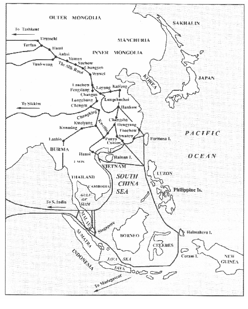
DID THE ROMANS REACH VIETNAM? Writing in the second century AD, Claudius Ptolemy used sailor accounts in his Geography (1.13-14) to describe the edges of the known world from the perspective of Romans and others living within the Mediterranean region. He detailed areas far to the east and beyond India, including what he called the Chryse Chersonesos (the Golden Peninsula), which scholars suspect may be the Thai-Malay Peninsula (Borell et al. 2014). One of the accounts described a port city referred to as Cattigara, situated at the mouth of the Cottaris River.
ARCHAEOLOGICAL EVIDENCE A combination of clues from both archaeological and textual records strongly suggest contact (whether directly or indirectly) between societies of the Mediterranean region and those of Southeast Asia, occurring within the first millennium AD if not earlier. This includes settlements located along the coastline of present-day Vietnam.
Modern scholars have considered the ancient port city of Oc Eo, located in the southern part of Vietnam approximately 200 km from the modern Ho Chi Minh City (formerly Saigon), as a potential candidate for Cattigara; with the Mekong River corresponding to ancient Cottaris. Whether Oc Eo was indeed the city of Cattigara is a point of ongoing speculation, debate, and research. Regardless, the archaeological evidence recovered from the ancient city of Oc Eo suggests contact with the Mediterranean world.
The Mekong delta region straddles southern areas of todays Cambodia and Vietnam. Settlements of this region dating to a period of AD 100-500, such as Oc Eo, show signs of elaborate architecture and links to expansive maritime trading networks. Oc Eo is considered to be an important port and urban center for a polity known as the Funan Kingdom. The kingdom was described in Sinitic texts such as History of the Jin Dynasty (Jinshu) and History of the Southern Qi (Nan Qishu) (Stark 2006). Two Roman medallions have been recovered from excavations at Oc Eo: one minted during the time of Antoninus Pius (AD 138-161) and the other during the reign of Marcus Aurelius (AD 161-180) (Higham 2014: 279). Also found at Oc Eo are pieces of jewelry either from or inspired by the Mediterranean region.
Archaeological materials, including Roman gold-glass ornaments and beads, have been found in various localities within Southeast Asia in the vicinity of the Mekong delta (Calo et al. 2020). The evidence clearly indicates the Mekong delta region having served as a hub in a wider network of exchange linking the Mediterranean, South Asia, Southeast Asia, and East Asia. Artifacts from these disparate areas have been found at Oc Eo and sites linked to it through canals, like Nen Chua (some 12 km away). In that regard, the Roman and Chinese empires of the first millennium were on either terminus of a long-distance maritime connection. Various societies along this vast network of travel and trade were in contact with one another, as reflected by the presence of South Asian deities and Sanskrit inscriptions in the Mekong delta.
In sum, archaeological investigations show how local and regional contacts and exchanges among communities sitting along rivers and coastlines fomented major social changes within the Mekong delta during the last centuries BC and early centuries AD (Le 2015). As important hubs within a burgeoning maritime system, the large plains and canal-river systems in southern Vietnam and Cambodia furnished a ready and abundant source of products sought by communities far afield, such as ivory and spices (Le 2015). In turn, materials like silk and semi-precious stones made their way in and out of the Mekong delta.
Moreover, the material evidence for the Oc Eo archaeological culture and the Funan Kingdom highlight incipient urbanism and ancient state development for Southeast Asia, and implicates early forms of globalization as part of these momentous developments. Funan is widely seen as one of the earliest examples of ancient states in Southeast Asia.
TEXTUAL DATA In addition to Claudius Ptolemys writings, pertinent textual evidence also comes from China.
Written texts compiled by court chroniclers of the Han Empire describe the arrival of diplomats or merchants from the Roman Empire (referred to as Daqin or Ta-ts`sin) at the capital city of Luoyang in China during this time period, likely using maritime routes (de Crespigny 2007). According to these sources, such as the Book of the Later Han (Hou Hanshu), the travelers claimed to have been sent by Andun (or An-tun), ruler of Daqin, which may correspond to Roman Emperor Marcus Aurelius Antoninus (88.12):
In the ninth yanxi year [166 CE], during the reign of Emperor Huan, the king of Da Qin (the Roman Empire), Andun (Marcus Aurelius Antoninus), sent envoys from beyond the frontiers through Rinan, to offer elephant tusks, rhinoceros horn, and turtle shell. This was the very first time there was [direct] communication [between the two empires]. The tribute brought was neither precious nor rare, raising suspicion that the accounts [of the envoys] might be exaggerated.
The travelers arrived with gifts including ivory, rhinoceros horn, and tortoise shell, which they likely acquired during their travels throughout parts of Southeast Asia. The travelers may have entered China from the south, by way of one of the Han Empires southern frontier commanderies known as Rinan (also known as Jih-nan, located in present-day central Vietnam) and Jiaozhi (present-day northern Vietnam) (Hill 2009). These areas were under varying degrees of Sinitic control for much of the first millennium AD.
Whether the travelers were actual Roman emissaries or subjects of the Roman Empire is still debated. Some scholars suspect the travelers were enterprising merchants and traders, perhaps from the empires eastern provinces, rather than imperial officials (see Borell et al. 2014: 112 and de Crespigny 2007: 600).
CONCLUSION Complementing the clues from various textual sources, the archaeological data constitute compelling evidence of contact between the Roman world and communities in areas of modern Vietnam. In totality, the various sources of evidence can be knitted together to generally support the claim that Romans had contact with the region of modern Vietnam, though how direct and specifically by whom is unclear.
As mentioned above, the frequency and nature of the contacts are subject to ongoing debate. Another caveat, of course, is that the entity we know of as Vietnam did not exist two thousand years ago, just as there was no Italy. Instead, some of the earlier, precursor societies of what would become part of southern and central Vietnam (during the second millennium AD) were in contact with Roman entities during the first millennium AD. These contacts occurred during a period of proto-history or early history for the Mekong area, and the archaeological evidence from sites like Oc Eo is crucial for research questions dealing with the earliest linkages between societies on either side of the Eurasian landmass.
In that regard, the claim of Roman-Vietnam contact is not only interesting, but also significant for our understanding of historical trends leading to the globalized world we find ourselves in today.
-------------------- Mahirap gisingin ang nagtutulog-tulugan. Posts: 26246 | From: Atlanta, Georgia, USA | Registered: Feb 2005
| IP: Logged |


 UBBFriend: Email this page to someone!


 Printer-friendly view of this topic