The close link between human settlement and climate has lessons for today, researchers report in Science.
"Even modern day conflicts such as Dafur are caused by environmental degradation as it has been in the past," Dr Stefan Kropelin of the University of Cologne, Germany, told the BBC News website.
"The basic struggle for food, water and pasture is still a big problem in the Sahara zone. This process started thousands of years ago and has a long tradition."
Jigsaw puzzle
The Eastern Sahara, which covers more than 2 million sq km, an area the size of Western Europe, is now almost uninhabited by people or animals, providing a unique window into the past.
Dr Kropelin and colleague Dr Rudolph Kuper pieced together the 10,000-year jigsaw of human migration and settlement; studying more than 100 archaeological sites over the course of 30 years.
In the largest study of its kind, they built up a detailed picture of human evolution in the world's largest desert. They found that far from the inhospitable climate of today, the area was once semi-humid.
Nomadic human settlers moved in from the south, taking up residence beside rivers and lakes. They were hunter-gatherers at first, living off plants and wild game.
Eventually they became more settled, domesticating cattle for the first time, and making intricate pottery.
Neolithic farmers
Humid conditions prevailed until about 6,000 years ago, when the Sahara abruptly dried out. There was then a gradual exodus of people to the Nile Valley and other parts of the African continent.
"The Nile Valley was almost devoid of settlement until about exactly the time that the Egyptian Sahara was so dry people could not live there anymore," Dr Kropelin told the BBC News website.
"People preferred to live on savannah land. Only when this wasn't possible they migrated towards southern Sudan and the Nile.
"They brought all their know-how to the rest of the continent - the domestication of cattle was invented in the Sahara in the humid phase and was then slowly pushed over the rest of Africa.
"This Neolithic way of life, which still is a way of life in a sense; preservation of food for the dry season and many other such cultural elements, was introduced to central and southern Africa from the Sahara."
posted
^ Excellent recap. This should always be kept in mind when talking about the false division of Africa into 'North' and 'Sub-Sahara'. There were periods when the Sahara waned to the point that there was NO Sahara and other times when it waxed to the point that many countries now called 'Sub-Saharan' were part of the Sahara. Even the paleontological evidence shows this with many flora and fauna species being found on both polar ends of the continent.
Tukuler Member # 19944
posted
I need more of these maps (with the rest of the world too) like for back 120k or at least 80K to just before OoA event.
With these maps climate and geography show when and where spread and migration was facile or restrictive for gene flow.
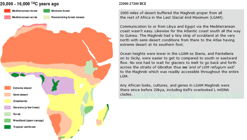
1000 miles of desert buffered the Maghreb proper from all the rest of Africa in the Last Glacial Arid Maximum.
Communication to or from Libya and Egypt via the Mediterranean coast wasn't easy. Likewise for the Atlantic coast south all the way to Guinea. The Maghreb had a tiny strip of scrubland at the very north with semi-desert conditions from there to the Atlas having extreme desert at its southern foot.
Ocean heights were lower in the LGAM so Iberia was very easy to get to (maybe Pantelleria on to Sicily too) when compared to south or eastward flow. No one had to wait for glaciers to melt to go back and forth across the straits of Gibraltar thus no end of LGM refugium exit to the Maghreb which was readily accessible throughout the entire LGM.
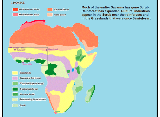
Any African looks cultures genes in LGAM Maghreb were there since before 20k including Kefi's overlooked L mtDNA clades. By 11K scrub replaced Maghreb's semi-desert while earlier scrublands forested but desert extremes still waited beyond.
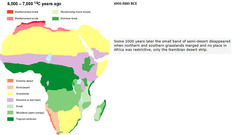
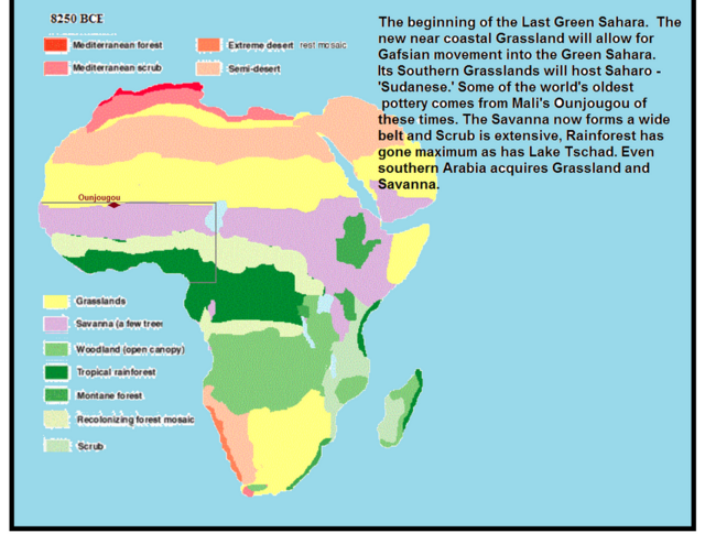
As the Holocene starts and at the end of Maurusian times folk were very easily following fertile landscapes all over Africa. Scrubland spread a little south and eastward across the farther north of Libya and Egypt while south of that whole swath were grasslands down to 10° N. Some 2000 years later the small band of semi-desert disappeared when northern and southern grasslands merged and no place in Africa was restrictive only the Namibian desert strip.
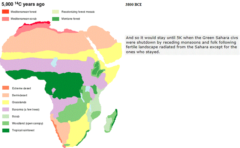
And so it would stay until 5K when the Green Sahara civs were shutdown by receding monsoons and folk following fertile landscape radiated from the Sahara except for the ones who stayed.
Adjust zoom 75% to see 3 in a row ---------------
_ the early Holocene ___________________________ just before the Younger Dryas _______________ full glacial arid conditions
the mid Holocene ______________________________ the early-to-mid Holocene___________________ the early Holocene
Troll Patrol Member # 18264
posted
Great info.
Tukuler Member # 19944
posted
Thank ya but oops
Scrubland spread a little south and eastward across the farther north of Libya and Egypt while south of that whole swath were grasslands down to 10° N.
should be 28° N.
Tukuler Member # 19944
posted
Restoring the mid-Holocene map
Tukuler Member # 19944
posted
Wanted to post some of the images to another thread and found them rescinded yet once again, so, instead, some later work. As always comments, precisions, and critique are welcome and solicited.
Sorry for north africentric text. Been working on a more continental inclusive set of captions.
Tukuler Member # 19944
posted
Sorry for the rough look but wanted examples with text considering other than Mediterranean Africa.
Corrigenda: In that last two blurbs, replace SCRUB with RECOLONIZING FOREST MOSAIC.

 posted