quote:Originally posted by xyyman: It is really hilarious and mind buggling how these Euronutz think. Sometimes I am tempted to call the disease Albinism(melanin deficiency). It fukgs with their minds.
They assume that these prehistoric Africans will see a land mass a few miles away(Iberia). Land they can probably swim to but instead will say to themselve, fugk it, we will take the long way around. 4000 miles East to the Sinai and then back 4000miles to Iberia. Lol! Along the way they will see Sardinia and Malta and Sicily and the Greek Islands. These Africans will ignore all these land mass but cross the Sania and/or build a boat to cross the Straits of Bal Barb or the Red Sea. Stupid Africans will not build a boat to cross the Straits of Gibraltar. Lol!
What is even more fascinating is some of these idiot blacks repeat the same nonsense.
There is also the fact that DURING THE ICE AGE, there was an ACTUAL LANG BRIDGE, AND A SINGULAR PENINSULAR LAND MASS THAT CONNECTED AFRICA WITH EUROPE, and the British Isles and Western Europe, AND NORTHERN EUROPE, into a single area.
I have mentioned this before here on ES, but due to this geologic area existing, why wouldn't Ice age era Africans SIMPLY WALKED from Africa TO EUROPE, ON AND THROUGH THIS LAND MASS to REACH THE BRITISH ISLES AND POPULATE IT, WHEN THEY DIDN'T EVEN NEED BOATS TO DO THIS, because of this land mass existing?
The European Albino's are extremely good when it comes to the mental gymnastics they employ about their false duplicitous history and all the hard work they put in, into maintaining all the falsities that can be seen of it...
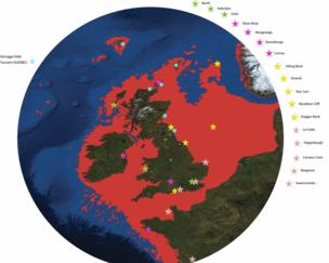
quote:Originally posted by Mindovermatter: Of course these delusional albino researchers are not also taking account stuff like this, which again their models don't take in account, because after all all of the British Isles to Scandinavia to northern Europe was connected in a gigantic landmass known as "dogger land".
A huge area of land which was swallowed up into the North Sea thousands of years ago has been recreated and put on display by scientists. Doggerland was an area between Northern Scotland, Denmark and the Channel Islands.
It was believed to have been home to tens of thousands of people before it disappeared underwater.
Now its history has been pieced together by artefacts recovered from the seabed and displayed in London. The 15-year-project has involved St Andrews, Dundee and Aberdeen universities.
The results are on display at the Royal Society Summer Science Exhibition in London until 8 July. The story behind Doggerland, a land that was slowly submerged by water between 18,000 BC and 5,500 BC, has been organised by Dr Richard Bates at St Andrews University. Dr Bates, a geophysicist, said "Doggerland was the real heartland of Europe until sea levels rose to give us the UK coastline of today.
"We have speculated for years on the lost land's existence from bones dredged by fishermen all over the North Sea, but it's only since working with oil companies in the last few years that we have been able to re-create what this lost land looked like.
"When the data was first being processed, I thought it unlikely to give us any useful information, however as more area was covered it revealed a vast and complex landscape.
"We have now been able to model its flora and fauna, build up a picture of the ancient people that lived there and begin to understand some of the dramatic events that subsequently changed the land, including the sea rising and a devastating tsunami."
Ancient tree stumps, flint used by humans and the fossilised remains of a mammoth helped form a picture of how the landscape may have looked. Researchers also used geophysical modelling of data from oil and gas companies. Findings suggest a picture of a land with hills and valleys, large swamps and lakes with major rivers dissecting a convoluted coastline.
As the sea rose the hills would have become an isolated archipelago of low islands. By examining the fossil record (such as pollen grains, microfauna and macrofauna) the researchers could tell what kind of vegetation grew in Doggerland and what animals roamed there. Using this information, they were able to build up a model of the "carrying capacity" of the land and work out roughly how many humans could have lived there.
The research team is currently investigating more evidence of human behavior, including possible human burial sites, intriguing standing stones and a mass mammoth grave.[b]
And the fact that there was a land bridge that connected Spain and Northern Africa as recently as the last ice age, until the glacial ice sheets began to melt.
"Relentless. The refilling of the Mediterranean may have required the largest river that ever flowed."
"A Flood, Not a Falls, Refilled the Mediterranean"
All it took to get started was a trickle. Researchers have found evidence that the Atlantic Ocean refilled the dried-out Mediterranean basin about 5.3 million years ago in a gigantic flood, which started slowly but accomplished most of the task within as little as several months.
Today, the crystal-blue waters of the Mediterranean Sea cover some 2.5 million square kilometers. But 5.3 million years ago, that same area was a desert peppered by extremely salty lakes with depths down to 2.7 kilometers below current sea level.
The sea's waters had evaporated about 300,000 years earlier, when the Mediterranean's only inlet at the time, the Strait of Gibraltar, blocked the flow of seawater from the Atlantic Ocean. EARLIER RESEARCH HAD SUGGESTED THAT A MAJOR ICE AGE HAD CAUSED SEA LEVELS TO DROP, EXPOSING A LAND BRIDGE BETWEEN EUROPE AND AFRICA.
THEN, WHEN THE ICE AGE ENDED, THE SEA ROSE AGAIN. EVENTUALLY, IT BREACHED THE LAND BRIDGE, CREATING WHAT WAS CALLED THE GIBRALTAR FALLS. SOME SCIENTISTS HAD DESCRIBED THOUSANDS OF TIMES MORE WATER FLOWING OVER THE FALLS THAN AT NIAGARA. BUT THE EVIDENCE FOR THIS SCENARIO HAS REMAINED SKETCHY AND THE ICE-AGE EXPLANATION HAS BEEN QUESTIONED.
NOW A TEAM OF RESEARCHERS HAS PROVIDED A MORE-NUANCED PICTURE OF THE BREACHING OF THAT NATURAL DAM: INSTEAD OF COLLAPSING, IT ERODED OVER THOUSANDS OF YEARS. DANIEL GARCIA-CASTELLANOS, A GEOPHYSICIST OF INSTITUT DE CIÈNCIES DE LA TERRA JAUME ALMERA IN BARCELONA, PART OF THE SPANISH NATIONAL RESEARCH COUNCIL, AND COLLEAGUES REVIEWED ALL AVAILABLE DATA FROM BOREHOLES AND SEISMIC STUDIES AND ANALYZED THAT DATA USING MODELS DESIGNED TO SIMULATE HOW FAST-MOVING RIVERS CAN CARVE OUT CHANNELS.
BASED ON THAT ANALYSIS, THE TEAM CONCLUDES, THE FLOOD BEGAN AS A RELATIVE TRICKLE, AS THE LAND BRIDGE SUBSIDED A BIT. OVER THE NEXT SEVERAL THOUSAND YEARS, THE RAPIDLY GROWING STREAM CARVED A NOTCH DEEPER AND DEEPER INTO THE LAND, UNTIL THE INFLOW OF SEAWATER BECAME OVERWHELMING--CONTAINING POSSIBLY 1000 TIMES MORE WATER THAN THE AMAZON RIVER DOES TODAY.
ALTHOUGH THE FLOOD BUILT UP GRADUALLY, IT NEVERTHELESS GREW TO ENORMOUS PROPORTIONS. UP TO 90% OF THE REFILLING TOOK PLACE IN LESS THAN 2 YEARS--PERHAPS ONLY A FEW MONTHS--RAISING THE WATER LEVEL IN THE MEDITERRANEAN BASIN BY MORE THAN 10 METERS A DAY AT ITS PEAK, THE SCIENTISTS ARGUE TOMORROW IN NATURE. THE ACTION OF THAT MUCH WATER CARVED A 200-KILOMETER-LONG CHANNEL RIGHT THROUGH THE CENTER OF THE STRAITS, DEEPENING IT BY AS MUCH AS 0.4 METER A DAY. AS SOON AS THE FIRST TRICKLE OF ATLANTIC WATER FOUND THE WAY THROUGH IT, THE FEEDBACK BETWEEN EROSION AND WATER FLOW LED TO [THAT] ENORMOUS DISCHARGE IN A SHORT PERIOD," Garcia-Castellanos says.
The remaining mystery is the process that blocked the Mediterranean in the first place and then refilled it. "Our models do not help much in knowing what brought on the topographic divide between both seas," Garcia-Castellanos admits, but he suspects the cause was subsidence of tectonic plates.
It's a "very convincing" bit of research, says geologist Philip Gibbard of the University of Cambridge in the United Kingdom.
The idea of a gentle influx growing into a gigantic torrent seems "perfectly reasonable." But to be sure, Gibbard suggests testing the erosion model further, by conducting lab experiments or perhaps applying it to data related to similar refillings of other basins in the geological record, such as the Black Sea.
Incredible that moronic albinotic researchers like in the OP article do not take into account events and geologic and geographical changes like this, when they are making their population genetic arguments....


 UBBFriend: Email this page to someone!


 Printer-friendly view of this topic