*Department of Anthropology, Yale University, 10 Sachem Street, New Haven, CT 06511, USA (Email: douglas.park@yale.edu)
Timbuktu, an iconic destination for medieval caravans crossing the Sahara, has a prehistoric phase, here before AD 1000, which shows varying urban traits. The author's new project examines the context of Timbuktu's prehistoric urbanism by mapping the settlement patterns in its hinterland, and seeks to understand the social impacts of the Sahara's changing climate.
Keywords: Mali, Sahara, Sahel, first millennium AD, urbanism, climate change.
^Shot out to alTakuri for hipping me to this guy's research. This is a recent paper by Douglas Post Park out of Yale. I Haven't seen much in the way of research concerning the initial settlement of Timbuktu but the picture that emerges seems to substantiate oral and written Sahelian tradition, that Timbuktu was founded as a seasonal settlement for the Tuareg and developed later into an urban center coincident with Djenne. Some highlights:
quote:Phase 1 Phase 1 ceramics (Figure 5) are similar in both style and form to central Saharan proto- Berber twine-impressed and sand-tempered ware (R.McIntosh & S.McIntosh 1985: 312; cf. Castelli et al. 2005; cf. Gatto 2005). Provisionally, it is suggested that there may be connections between contemporary Garamantian ceramic assemblages from the central Libyan Desert (Gatto pers. comm.). Phase 1 generated significant amounts of fish and aquatic faunal material, with fewer goat/sheep and cow remains when compared to the upper levels. Evidence for iron smelting in the form of iron slag was abundant in Phase 1, along with large quantities of red and yellow ochre. The final level of Phase 1 witnesses a possible short abandonment as evidenced by a collapsed building and burnt roof beams. Preliminary dates for this phase are from c . 500400 BC to a radiocarbon date of cal AD 120330 (at 95% probability) (Beta-256796).
^^Interesting. Of course, many have had their suspicions that Tuareg are direct descendants of the Garamantes but is this the first indirect link, assuming what is implied by the convergence of local history and archaeology is true?
The influence of the Djenneans (sic):
quote:Phase 2 Phase 2 ceramic decorations are similar to a painted red- or black-on-white geometric style found in small numbers at Phase III Jenn´e Jeno (S. McIntosh 1995: 155), although applied to possible Saharan vessel types with localised variations in style (Figure 5). Paint is often applied over horizontal channelling in cross-hatched patterns. Polychrome sherds (red, purple and white) are also common and paints are usually applied over the body of the vessel in a distinctive zonal manner, i.e. a solid purple band separating a solid red band below and a purple-on-white cross-hatching pattern above. In the cultural accumulation above the abandonment of Phase 1 (1.1m deep), large amounts of carnelian and glass beads were found along with a slightly reduced amount of iron slag. Far less aquatic fauna was discovered, and a significant increase in sheep/goat and cow remains was found. Radiocarbon dates for this phase are cal AD 120330 (at 95% probability) to cal AD 430640 (at 95% probability) (Beta-256795).
and
quote:Phase 3 Phase 3 ceramics were characterised by ribbed/channelled, red slipped, rocker combed and burnished wares typical of Gao Ancien (Insoll 1996: 834, 2000) and, alongside the 0.8m of cultural accumulation, provide a preliminary chronological interpretation that limits the sites terminus date to c . AD 9001000 (Figure 5). It is thus far believed that, due to the complete absence at TBZ1 of imported glazed pottery, which may have come into Gao as early as the tenth to eleventh centuries AD (Insoll 1996: 65), it is unlikely that the population at TBZ1 persisted far into the second millennium AD. With an area of 40ha and an elevation of 3.4m, TBZ1 proved to have a long-term occupation spanning from around 500400 BC to about AD 9001000. The TBZ1 Phase 3 chronology of cal AD 430640 (at 95% probability) ending in 9001000 AD coincides with periods 5 and 4 from Gao Ancien (MM96[C]) (Insoll 2000: 4). It is suggested that, due to the similarities in ceramic style between TBZ1 and Gao Ancien, an informal social or economic relationship may have existed between the two sites. Other than ceramics, almost no aquatic fauna are found in this level, and the ratio between goat/sheep and cow remains suggests that bovids were the most common form of meat. Fewer beads were recovered, and an increase in smelting activity is present in amounts far greater than what was found in either Phase 1 or Phase 2.
Posts: 4021 | From: Bay Area, CA | Registered: Mar 2007
| IP: Logged |
posted
^Now let's try this again, and I'll start with an inquiry.
Is anyone else aware of evidence linking the Tuareg of Mali with the Garamantes or of trade relations between the Garamantes and the proto-Soninke of Dhar Tichitt?
-------------------- mr.writer.asa@gmail.com Posts: 4021 | From: Bay Area, CA | Registered: Mar 2007
| IP: Logged |
posted
I wish I could answer your question, Sundjata, but the sad thing is that I know much less about West Africa than I do the Nile Valley. However, if we're going to be discussing prehistoric West Africa in general...exactly how old is civilization in that part of the continent? Most history books I have read start with historical Ghana, but the existence of the Dhar Tichitt ruins attests to some form of civilization in West Africa existing as far back as 2000 BC. I also recall hearing that the Khartoum Mesolithic culture of 7400 BC was part of a larger culture of pottery-makers that stretched across the Sudanic belt, which implies that West Africans had also taken up sedentary or semi-sedentary living during that period. Given all that, I would not be surprised if West African civilization rivaled that of the Nile Valley in age. Is that the case?
Sundjata...Let me just start off and say, Don't EVER leave this forum. We need more posters like you and not less.
Moving on.
I remember a while back someone I think Ausar posted an excerpt from a Study that stated that the Garamantes were people who were in Libya and they use to attack people that were called "little Negroes". How true that is I don't know, but I also think that the Tuareg closely apply to the Garamantes in how they were described.
Take note of this Sundjata from Professor Mattingly: "Our research is revealing that, with human ingenuity and against all the odds, the people of the world's largest desert were able to create a prosperous and successful civilisation in one of the driest and hottest wildernesses on earth. The Romans liked to think of the Garamantes as simple barbarians. The new archaeological evidence is now putting the record straight and showing they were brilliant farmers, resourceful engineers and enterprising merchants who produced a remarkable civilisation."
So we see that the Garmantes were thought of as people who were Barbarians, but that was far from the case. They were innovators who created a Civi in the Heart of the Sahara.
Moving on...The Garamantian civilisation reached its peak in the second and third centuries AD, when the new archaeological evidence suggests it became one of the Roman Empire's main trading partners.
Archaeologists believe large quantities of African gold, ivory, salt, semi-precious stones and slaves were supplied to the empire via the Garamantian kingdom.
According to Herodotus in his famous work The Histories, the Garamantes were a powerful kingdom, and they were the first to introduce the Greeks to the 4 horse chariots. He also claimed The Garamantes lived further inland behind the Nasamones in the land of wild beasts .Again at the same distance to the west is a salt-hill and spring, just as before, with date palms of the fruit-bearing kind, as in the other oases; and here live the Garamantes, a very numerous tribe of people, who spread soil over the salt to sow their seed in. From these people is the shortest routethirty days' journeyto the Lotophagi; and it is amongst them that the cattle are found which walk backwards as they graze. The Garamantes hunt the Ethiopian cave dwellers, or troglodytes, in four-horse chariots, for these troglodytes are exceedingly swift of footmore so than any people of whom we have any information.
According to Pliny the Elder and Tacitus
The Garamantes would consistently raid the Roman coastal settlements, and did not easily give in to the Romans. Up to the present, it has been found impracticable to keep open the road that leads to the country of the Garamantes, as the robber bands of that people have filled up the wells with sand, which wells do not require to be digged to any great depth, if you but have knowledge of the locality.
Garamantes Chariot Riders
Garamantes Warriors:
Read this Article Sundjata that speaks a Little about Tuareg Mali and the Garamantes:
Ghadames has been a focal point on the Saharan landscape for thousands of years. It is located at the triple junction of Libya with Tunisia and Algeria. Perhaps the unique character of the city derives from its special position, not only geographically but also culturally. Ghadames is characterized by many intersections and transitions: It is located at the western edge of the Red Plateau (al-Hamada al-Hamra) that forms the transition between the Sahara in the south and the Nefousa mountain and the coastal region in the north.
Historically, Ghadames was a stronghold on the northern edge of the Garamantes territory until the year 19 BC when it fell to the Romans and became a critical garrison on the southern edge of their empire. The Arabs entered Ghadames late in the seventh century, as Islam spread westward across North Africa. The modern population of Ghadames is integrated under the umbrella of Islam, with a variety of cultural and ethnic roots, including northern and southern Amazigh (or Berbers and Touareg), Arabs and sub-Sahara Africans. The same variety is reflected in other aspects of the local culture and traditions, including the dialect, the old Ghadamsi numbers, and of course, the Ghadamsi architecture.
The long history of Ghadames naturally has its share of myths and legends. The most widely circulated legends surround the name Ghadames and the name of its lifeline, Ein al-Faras (or Mare Spring.) In Arabic, the word "Ghada" means lunch and "Ams" means yesterday, and this has led to a fairly common misunderstanding that the name Ghadames was coined by desert travelers in reference to the location where they had previously stopped for lunch. In another legend, the name Ein al-Faras is said to refer to the (miraculous) birth of the spring under the pounding hoof of a mare belonging to the tribe of Nemrod, or in another account to Uqba ibn Nafe', the Muslim leader who conquered Ghadames. In reality, Ghadames existed long before the arrival of Arabs and Arabic, and it is difficult to imagine how it could have survived without its spring. The Roman name Cydamus was probably the precursor to the modern name, but Cydamus itself might have been influenced by older names; .e.g, there is an older reference to the Garamante town as Kidamae in ancient Mediterranean history.
On a global scale, Ghadames has had a far reach because of trade. The economy blossomed in the days of caravan trade through the Sahara, which included trading in commodities and slaves, and reached its final climax a couple of centuries ago. Ghadames linked the African interior with partners from the coastal region and beyond. The breadth of trading interests in Ghadames' history is reflected in the variety of currencies in circulation at one time and even in the concurrent units of weight and measure. The skilled traders routinely covered a territory stretching from Kano (Nigeria) in the south, to Timbukto (Mali) in the west, to the Sudan and the Arab peninsula in the east, and every place in between! On rare occasions, private Ghadamsi traders reached as far north as Manchester, England! And the Guadameciles leather crafts of southern Spain represent another imprint of Ghadames on the face of Earth.
Given the beautiful diversity behind Ghadames, we Libyans should consider establishing a new legend about its name. Maybe future generations of Libyans would say the name means bouqouet, for the city of Ghadames is a beautiful Libyan bouquet of world cultures.
Fortunately, apart from commerce and legend, the city of Ghadames has also attracted scientific interests. In the following piece, Dr. Intisar Azzouz provides a sharp description of the city from her point of view as a Libyan architect http://www.tibra.org/spotlight/dec03/intro.htm
Read this Study that states that Tuareg from Libya have an west eurasian gene called H1
Mitochondrial Haplogroup H1 in North Africa: An Early Holocene Arrival from Iberia
The Tuareg of the Fezzan region (Libya) are characterized by an extremely high frequency (61%) of haplogroup H1, a mitochondrial DNA (mtDNA) haplogroup that is common in all Western European populations. To define how and when H1 spread from Europe to North Africa up to the Central Sahara, in Fezzan, we investigated the complete mitochondrial genomes of eleven Libyan Tuareg belonging to H1. Coalescence time estimates suggest an arrival of the European H1 mtDNAs at about 8,0009,000 years ago, while phylogenetic analyses reveal three novel H1 branches, termed H1v, H1w and H1x, which appear to be specific for North African populations, but whose frequencies can be extremely different even in relatively close Tuareg villages. Overall, these findings support the scenario of an arrival of haplogroup H1 in North Africa from Iberia at the beginning of the Holocene, as a consequence of the improvement in climate conditions after the Younger Dryas cold snap, followed by in situ formation of local H1 sub-haplogroups. This process of autochthonous differentiation continues in the Libyan Tuareg who, probably due to isolation and recent founder events, are characterized by village-specific maternal mtDNA lineages.
posted
Tichitt-Walata and Tagant Settlements of SUDANIC AFRICA
INTRODUCTION
The significance of the Sudan must be viewed in the context of expansion, enlarged settlements and increasing geographic scale of trade and interaction, the growth of powerful military aristocracies, with their cavalry-based armies, the specialization of crafts, music and art guilds, the organization of administrative systems, urban sprawl, and the ascendance of the merchant groups. All these things contributed to the accumulation and circulation of wealth in the region, and ultimately in the world.
GEOGRAPHY
What is Sudanic Africa? 10th century geographer Ishaq ibn al-Husayn offered a suitable historical starting point. He describes it thus: The land of the Sudan, an extensive country, stretching from the Western Sea [Atlantic Ocean] to the Red Sea [is] an enormous and important land.
Geographically, this vast territory comprises at least these major ecological zonesthe Sahara, the Sahel, and the savanna or grasslands. Scholars divide the Sahel and grasslands into three macro-regions: the Western Sudan (historic cores: the Upper and Middle Niger Valleys and the Senegal Valley), the Central Sudan (historic core: the Lake Chad basin), and the Eastern Sudan (historic core: the Middle Nile Valley).
The Middle Niger Valley was known as the land of Wangara in Muslim geographical sources, and in the works of Latin Christian cartographers it was called Palolus - Island of Gold. In this context, Ishaq ibn al-Husayns reference to the Sudan as an important land becomes patently clear.
EARLY HISTORY
Before 2000 BC, what is today the southern Sahara was inhabited by significant numbers of herders and farmers. On the rocky promontories of the Tichitt-Walata (Birou) and Tagant Plateaus in modern day Mauritania, they built what are considered among the earliest known civilizations in western Africa. Composed of more than 400 stone masonry settlements, with clear street layouts, some settlements had massive surrounding walls while others were less fortified. In a deteriorating environment, where arable land and pasturage were at a premium, the population grew and relatively large-scale political organizations emerged - factors which no doubt explain the homogeneity of architecture, settlement patterns, and material culture (e.g., lithic and ceramic traditions). This agro-pastoral society traded in jewelry and semi-precious stones from distant parts of the Sahara and Sahel, while crafts, hunting, and fishing were also important economic pursuits. Their elites built funerary monuments for themselves over a period extending from 4000 to 1000 BC.
Beginning around 600 BC, Tichitt-Walata entered a period of crisis which continued until 300 BC, although some settlements and cultural elements survived until the 4th century AD. The decline of architectural and material culture is evident in the archaeological record and settlement pattern, as towns were abandoned and villages became concealed and fortified. Increasingly arid conditions certainly contributed to this situation, as well as military forays from the east and north - which disrupted the regional centers control over trade routes - and political/military upheavals internally.
In the words of one archaeologist, the abandoned sites they left behind represent a great wealth of rather spectacular prehistoric ruins and perhaps the most remarkable group of Neolithic settlements in the world (Mauny, 1971).
MIGRATION
Between 200 BC and 100 AD, the Sahel experienced significant dry episodes which were part of the general drying trend that had been seriously underway since before 2000 BC. Southern Saharan populations were moving southward along southward-draining river systems where they found more congenial environments. Two of these were the great floodplains of the Middle Niger Valley and the Senegal Valley.
The Central Saharan-based Garamantes Kingdom was expanding in this period as well, and it is possible that a military force from this polity temporarily occupied Tichitt-Walata. However, the contact was not only military. There were important cultural and material exchanges. For example, chariots, depicted in numerous rock art images, appeared for the first time.
The situation of Tagant, to the east, was different. This civilization had more than 300 dry-stone settlements, which, in terms of their architecture, material culture, settlement differentiation and hierarchies, specialized production systems, and so on, were practically identical to those of Tichitt-Walata. However, Tagant survived the Garamantes arrival and the ecological degradation.
Consequently, following the decline and collapse of the Garamantes Empire - between the 4th and the 6th centuries AD, western domination began again - this time under Ghana/Wagadu. Between the 6th and the 8th century AD, Ghana/Wagadu established itself as the hegemonic political and commercial capital of the Western Sudan. Together with the Hodh and Awkar districts, Tichitt-Walata and Tagant formed the kingdoms heartland for more than a thousand years. In that time, Ghana/Wagadu and its rival, Kawkaw/Gao, reigned as the two most dominant social-political systems in the Sudanic world. (Monteil, 1953).
REFERENCED SOURCES
Mauny, R. (1971), The Western Sudan in Shinnie: 66-87. Monteil, Charles (1953), La Légende du Ouagadou et lOrigine des Soninke in Mélanges Ethnologiques (Dakar: Bulletin delInstitut Francais delAfrique Noir).
From Tichitt
David Phillipson's African Archaeology (1994)
Those pics show a little about Tichitt and it's settlement. Hope this helps others who are learning about the Garamantes and its relations to West Africa.
Posts: 9651 | From: Reace and Love City. | Registered: Oct 2005
| IP: Logged |
[quote]I remember a while back someone I think Ausar posted an excerpt from a Study that stated that the Garamantes were people who were in Libya and they use to attack people that were called "little Negroes". How true that is I don't know, but I also think that the Tuareg closely apply to the Garamantes in how they were described.
It is not true, that's mistranslated. Herodotus did talk about a people known as "troglodytes" and the "troglodytes" were described as short AND Ethiopian. However, as you imply, so were many Garamantes (described as Ethiopian), so that would mean that we can translate some of those Garamante descriptions as meaning "big negro".
But indeed, the old descriptions correspond to the Tuareg of today, as some were described as Ethiopians and others as more light-skinned.
Great info also KING! It makes me wonder who EXACTLY the Garamantes were with respect to the different Lybian entities that preceded them, such as the Tenehu (those pre-chariot driving Lybians prior to contact with the people of the sea).
They may have been a Tenehu offshoot who were later influenced by the people of the sea and later Temeju Lybians.
Let's also remember that the Tuareg are currently the only Berber group who have preserved the ancient Lybian script, now known as Tifinagh.
quote:
Read this Study that states that Tuareg from Libya have an west eurasian gene called H1
Mitochondrial Haplogroup H1 in North Africa: An Early Holocene Arrival from Iberia
The Tuareg of the Fezzan region (Libya) are characterized by an extremely high frequency (61%) of haplogroup H1, a mitochondrial DNA (mtDNA) haplogroup that is common in all Western European populations. To define how and when H1 spread from Europe to North Africa up to the Central Sahara, in Fezzan, we investigated the complete mitochondrial genomes of eleven Libyan Tuareg belonging to H1. Coalescence time estimates suggest an arrival of the European H1 mtDNAs at about 8,0009,000 years ago, while phylogenetic analyses reveal three novel H1 branches, termed H1v, H1w and H1x, which appear to be specific for North African populations, but whose frequencies can be extremely different even in relatively close Tuareg villages. Overall, these findings support the scenario of an arrival of haplogroup H1 in North Africa from Iberia at the beginning of the Holocene, as a consequence of the improvement in climate conditions after the Younger Dryas cold snap, followed by in situ formation of local H1 sub-haplogroups. This process of autochthonous differentiation continues in the Libyan Tuareg who, probably due to isolation and recent founder events, are characterized by village-specific maternal mtDNA lineages.
How true is this Sundjata, and what are the implications for the Libyan Tuareg? Are they much different from Mali Tuareg?
Peace
The Lybian Tureg picked it up from the coastal Mahgreb. If I recall, there was another study posted on more southernly Tuareg (I may be mistaken) that found different results but I need to double check. Overall it doesn't mean anything since per Tishkoff (2009) the Tuareg most closely resemble the Beja, who are neither Lybian, Mahreban, or West African.
^Which is also interesting. What to make of those Lybian and C-group connections people are/were always trying to make (as recently as Mokhtar-2007)? That may very well tie in here....or not. I'm going to look for some references concerning that.
Posts: 4021 | From: Bay Area, CA | Registered: Mar 2007
| IP: Logged |
quote:Originally posted by Truthcentric: I wish I could answer your question, Sundjata, but the sad thing is that I know much less about West Africa than I do the Nile Valley. However, if we're going to be discussing prehistoric West Africa in general...exactly how old is civilization in that part of the continent? Most history books I have read start with historical Ghana, but the existence of the Dhar Tichitt ruins attests to some form of civilization in West Africa existing as far back as 2000 BC. I also recall hearing that the Khartoum Mesolithic culture of 7400 BC was part of a larger culture of pottery-makers that stretched across the Sudanic belt, which implies that West Africans had also taken up sedentary or semi-sedentary living during that period. Given all that, I would not be surprised if West African civilization rivaled that of the Nile Valley in age. Is that the case?
Jari had some EXCELLENT photos of the Tichitt-Walata tradition that he even incorporated into one of his videos, but I don't see the video on his page anymore. Indeed, the settlements at Dhar Tichitt are considered to be among the earliest stone "settlements" in the Sahara desert. Hence, "settlement", for some reason archaeologists have been reluctant to refer to these as towns as opposed to a stone walled village. Maybe I need to reacquaint myself with the distinction.
I posted a full article on it by the Black archaeologist (necessary to emphasize as there aren't very many) Augustin F.C. Holl in one of alTakuri's threads on ESR. Check it out:
quote:Originally posted by Calabooz': I guess I missed this thread. I'll look for some info to answer your questions and hopefully I'll find an answer. Hold on
Take your time. Posts: 4021 | From: Bay Area, CA | Registered: Mar 2007
| IP: Logged |
Now I have some info about the Sahara before it turned dry Read and Enjoy:
Before the Sahara dried 12,000-2,500 B.C.
Author: Winshall, Robert, Title: "When the Sahara Turned from Green to Brown--Postglacial Climate Change and Human Settlement in Central Sahara, 12,000 - 2,500 BC."
Date: 1996 Institution: California State University Advisor: Alan Almquist Degree: M.A.
Abstract: For decades, archeologists have been aware of evidence suggesting that the Sahara Desert was much wetter and greener thousands of years ago. It is now possible to characterize these locations, in terms of both aquatic and terrestrial biota, but by also providing some data on the human inhabitants of these ecotomes. This thesis focused primarily on the features of human settlement in the central Sahara, looking at lifestyles of the people and examining factors favoring a wetlands economy. Finally, as the once-favorable conditions began disappearing, analysis of the destiny of these Saharan peoples is made.
The Holocene followed the last glacial age, about 12,000 BC. The temperatures in the Sahara became appreciably warmer and the climate demonstrated a lower evapotranspiration rate. The Intertropical Convergence Zone (ITCZ), the line along which north and south weather fronts converge, seems to have moved several hundred miles to the north. Since, in general, African rainfall north of the equator increases as one heads south, the shift of the ICTZ resulted in Saharan and sahelian zones receiving increased rainfall.
In addition to more temperate plant and animal species moving into the Sahara, the increased moisture resulted in lakes and rivers filling far beyond their prior capacity. In some cases, rivers breached their normal watershed, connecting with other systems. This allowed a broader distribution of aquatic species. In some areas, there were widespread wetlands. The earliest such sites, when associated with human habitation, date from ~7000 BC (with harpoons) and 6000 BC (wavy-line pottery). Because they used pottery, these cultures were originally considered some kind of Aquatic Neolithic.
JEG Sutton, in a 1974 article, called them the "Aquatic Civilization of Middle Africa". Although they did little stonework, he saw their bone work as very sophisticated. He suspected that much of their material culture, made of perishable materials, would not have survived. He thought them "victims" of stone-oriented scholars. Based on geographic distribution. he thought that the ancestors of Saharan, Songhai and Chari-Nile-speakers were these same "Middle Africans".
After the initial Holocene (postglacial) wet phase (12,000-7000 BC), conditions became drier for 500-1000 years. This was fol- lowed by a lesser wet phase of 2000 years. From then until 2500 BC, there was a gradual increase in dryness. After that time, weather conditions have been largely unchanged until the present. How did the human economies change with the climate?
The early harpoon-fishers availed themselves of large riverine and lake species, such as the Nile perch (known to exceed six feet). Whether they were fully-settled or did some amount of yearly travel isn't known. Undoubtedly, as water-tables dropped, the people needed to augment their aquatic diet with other foods. Initially, these would be available plant and animal foods which could be gathered.
Christopher Ehret's work touched on Sutton's language hypothesis--that these early fishers were NiloSaharan speakers. In the process of generating protolanguages for these speakers, he created an initial vocabulary for both NiloSaharan, proto-Saharan and proto-Sahelian. The words that he developed do not include fish or fishing terms (line, net, hook, harpoon). This early vocabulary does have herding terms and words for 'goat', 'young goat', 'cow', 'corral' and such. No other writers dealt with this topic.
The Central Sahara is punctuated by large stone outcrops--massifs--that create their own microclimate. In some cases, they represent a refuge for rare species, extinct everywhere else. Work by Henri Lhote in the 1950's documented the varied and colorful rockpaintings found in the massifs. Grouped into 23 styles, they are grouped as 1. Bubalus (extinct buffalo) hunters, early Neo- lithic; 2. 'Bovidian' pastoralists (considered Neolithic); 3. Equine phase, involving pastoralists with chariots and cavalry; 4. Phase of the camel, 1 AD. These groupings are disputed, but the images show us a wild-animal phase, then so-called 'Roundhead' figures. These appear to be multi-ethnic, including a 'Negroid' population.
The pastoralist period involved humpless cattle with large curved horns, similar to the ancient Egyptian Longhorn. Features of the people's life resemble activities of the Peul/Fulani, a contemporary West African pastoral group. Some of the boat images re- semble those on Egyptian monuments, raising yet other possibilities. Pastoralism appeared about the time that weather condi- tions became considerably drier (7000 BC), suggesting that it was a selected response to changing conditions.
The equine phase and its suspected timing may represent the arrival of the "Peoples of the Sea", groups that left Crete about 1500 BC (around the time of the Trojan War) and migrated northeast, east and southeast. The Biblical Philistines are one such group. Cretans arrived in NE Africa about 1200 BC, joining with the Libyans and attacking Egypt. Similar groups may have moved in from the coast and entered the central Sahara via the caravan trails. If so, this movement is more a political one than a response to climate change in the central Sahara, although its outcome would affect the local population.
Although the rock art isn't datable, it nevertheless shows us several different worlds of the central Sahara. The earliest involves Africa's megafauna (lions, elephants, etc) and Negroid peoples. Another one shows herding people with cattle. Some features of these images recall West Africa, others, Egypt. The herders look more like Somali people, with narrow noses, thin lips, straight hair. Probable intruders with horses and chariots are seen and, finally, the camel makes its appearance. Are the earlier people migrants from North Africa, from Egypt or from elsewhere?
Dhar Tichitt in southern Mauritania has been instructive as showing the cultural response to a drier climate. Digging revealed eight phases, from hunting megafauna (2000 BC), to limited hunting, gathering and herding (1500-1100). Subsequent phases included significant milling. The involved plant went from cramcram, a spiny famine food, to millet and sorghum. Identification of the species showed that the people had switched from gathering wild grasses to planting them, in about 100 years. Such speed is unheard of under normal circumstances, and suggests that the people were somehow "presensitized" to cultivation, perhaps via a smaller outgroup that grew up with farming and then migrated here. Both herding and planting were presumably responses to unfavorable climate. The site was abandoned after horses and metal weapons arrived, possibly with the charioteers described above.
The future of the central Saharans was not always the same as at Dhar Tichitt. Evidence suggests that the people migrated, some southwest, some southeast, some perhaps north, following the drying riverbeds as they sought sites where they could sus- tain themselves. Since West Africa had not yet been favorable to settlement, due to its dense forests, the central Saharans may represent some of the early ancestors of some of these peoples
More Info
In the western Sahel, the rise of settled communities was largely the result of domestication of millet and sorghum. Archaeology points to sizable urban populations in West Africa beginning in the 2nd millennium BCE. Symbiotic trade relations developed before the trans-Saharan trade, in response to the opportunities afforded by north-south diversity in ecosystems across deserts, grasslands, and forests. The agriculturists received salt from the desert nomads. The desert nomads acquired meat and other foods from pastoralists and farmers of the grasslands and from fishermen on the Niger River. The forest dwellers provided furs and meat.
Tichit(Dhar Tichitt) was prominent among the early urban centers, dated to 2000 BCE, in present day Mauritania. About 500 stone settlements litter the region in the former savannah of the Sahara. Its inhabitants fished and grew millet. Around 300 BCE, the region became more desiccated and the settlements began to decline, most likely relocating to Koumbi Saleh. From the type of architecture and pottery, it is believed that Tichit was related to the subsequent Ghana Empire. Old Jenne (Djenne) began to be settled around 300 BCE, producing iron and with sizable population, evidenced in crowded cemeteries. Living structures were made of sun-dried mud. By 250 BCE, Jenne was a large, thriving market town.
More pics of Dhar Tchitt
Visiting the Mauritanian region of Al Hawd, we find important prehistoric remains pre-dating the Soninke domination of the region. This is known as the Dhar Tichitt-Walata culture, a unique neolithic culture dating from between BC 2000 and the third century BC. No less than 400 settlements, some of them complete cities, made up this group of towns.
In all probability the legendary kingdom of Ghana, which for more than five centuries controlled the traffic in gold across the desert from western Sudan to the Mediterranean markets, arose from this civilisation, whose decline was triggered by a deterioration of the climate and the arrival of the Berbers in the region. It is precisely in this context that historians place the earliest references to Birou, a town of Soninke origin which centuries later was to become Walata.
Thanks to its privileged geographical situation, Walata became a crossroads of civilisations within Mauritania, the land of nomads. Traditionally it formed part of the trade route crossing the Sahara towards North Africa and was crossed by Arabs, Berbers and members of black cultures, all of whom left their cultural imprint. The city became an intellectual focus for Islam during the seventeenth and eighteenth centuries, when it was even a refuge for Muslim sages. At that time the city had six Koranic schools and the leading doctors of Islamic law gave their classes there. Each of the narrow streets and the buildings we come across on our visit to Walata are today a living example of the cultural heirloom of past centuries.
Hope this Info comes in Handy.
Peace
Posts: 9651 | From: Reace and Love City. | Registered: Oct 2005
| IP: Logged |
quote:Such speed is unheard of under normal circumstances, and suggests that the people were somehow "presensitized" to cultivation, perhaps via a smaller outgroup that grew up with farming and then migrated here. Both herding and planting were presumably responses to unfavorable climate. The site was abandoned after horses and metal weapons arrived, possibly with the charioteers described above.
So this occurred during the "Equine phase" and I'm wondering if perhaps this is the contact that I was looking for. The author just sucks at contextualizing the information, for instance, why would the inhabitants at Dhar Tichitt leave with the emergence of horses and metal weaponry? Wouldn't that benefit them? Was there any evidence of warfare or something, I mean why couple the two events? Seems more likely that they left because of increasing aridity/climate change.
quote:Walata became a crossroads of civilisations within Mauritania, the land of nomads.
LOL aren't "nomad" and "civilization" oxymoronic?! It can certainly be argued that the sedentary West African ethnys, such as the Soninke seem to have left the most indelible impression with respect to the latter term.
Posts: 4021 | From: Bay Area, CA | Registered: Mar 2007
| IP: Logged |
Patrick Munsonal thinks that warfare between Lybian Berbers was the cause of the destruction of Pre Ghana and also Dhar Tichitt. Read this Abstract:
Archaeology and the prehistoric origins of the Ghana empire Patrick J. Munsona1 a1 Indiana University
Archaeological investigations in southern Mauretania have revealed a wealth of rather spectacular stone masonry villages which were occupied by prehistoric cultivators as early as 1000 B.C. It is argued that the inhabitants of these villages were Negro and very probably Soninke, and that the basic elements of their culture had developed without major influences from outside the area. The apparent sophistication and complexity of this cultural manifestation, combined with the close fit of developments in this area with Carneiro's theory of state formation, suggests that this prehistoric complex represented at least a powerful chiefdom which embodied many of the characteristics of subsequent West African states. The first demonstrable outside influences in the area began about 600 B.C. with the arrival of Libyco-Berbers from North Africa. Rather than causing still further cultural advances, the initial effect of this contact was the collapse of this sociopolitical organization. But with subsequent adjustment, plus the potential from trans-Saharan trade carried out by the North Africans, the basic, pre-existing pattern re-emerged, resulting eventually in a second and much more powerful African political organization in this area the Ghana Empire.
This Article goes a little deeper in Dhar and the Lake Chad Basin:
Lake Chad BasinSettlement and Complexity Last time, I talked about the challenges of archaeology in West Africa, and particularly the area around the Inland Niger Delta of Mali. I spoke about our archaeological understandings of how complex societies appeared on this part of the African continent. These included a whole set of issues about the development of agriculture and settlement hierarchy in what's now the southern Sahara, at places like Dhar Tichitt in Mauritania, now desert. Also, questions of trade and the development of trade, especially the trans-Saharan trade as we try and understand how this trade developed in the 1st millennium CE, and actually potentially whether it may have existed in earlier times as well as the Sahara dried out; and the roles that, yet againbecause this is a theme in a whole variety of different areas we looked atexotic goods, goods coming from far away, may have played in the pathways to social hierarchy at sites like Kissi, at the cemetery site in northeastern Burkina Faso. I talked about the development of urbanism in the inland Niger itself, in the 1St millennium CE, and what may be some diversity in political and social structures in the region, because, as I noted last time, there's no reason necessarily to think that everything has to work in exactly the same way within a particular cultural region. I want to note especially the multiethnic nature of life in the Inland Niger Delta today; extremely complex relationships between different ethnic groups and occupational groups. Potentially, I think quite likely this was the case in the past, as well; and this may be related to these urban clusters, this particular form of urbanism that we see, for example, at the great site of Jenne jeno in the Inland Niger Delta. In parts of Africaand in many other areas of the world as well, of coursethese paths toward statehood are not always well understood at all, often because much less research has been done in such areas. This is certainly the case in the Lake Chad Basin of Central Africa, now partitioned between the modern states of Nigeria, Cameroon, Chad, and Niger, and the area where I do most of my archaeological research . I started working in northern Cameroon in the Lake Chad Basin in 1984, which seems like an extraordinarily long time ago now, at the beginning of my PhD program. I did my PhD there, over the next 10 years, and I've been working thereon and off ever since. After working for some years on a contract archaeology project involving the Chad-Cameroon Oil Pipeline, where we surveyed along a 700-mile stretch of oil pipeline right-of-way in southern Cameroon and Chad, I'm now back working in northern Cameroon again. It's a lovely area of the world, amazing area of the world, with a tremendous cultural diversity and really extraordinary people. The region that I work in, particularly the Mandarin Mountains of northern Cameroon and northern Nigeria, are one of the loveliest areas I've ever seen. As with the Inland Niger Delta and the Nile Valley, the Lake Chad Basin was very much affected by environmental changes around the Sahara over the last 10,000 yearsand this is something that I notedparallel processes in the Inland Niger Delta and around that region more generally. During the very wet early Holocene, Lake Chad expanded. This was the time period through which, as I said, the Sahara virtually disappears as a desert, replaced by a network of rivers and lakes, grasslands, and savannah in what's now the Sahara. During this period, Lake Chad expanded vastly, becoming a real inland sea that archaeologists and climatologists called Lake Mega-Chad, and with connections to the network of rivers and lakes that existed through the Sahara at this time. I've already noted that we really must recalibrate our expectations of African climates through this area; and this affects all sorts of different cultural patterns and processes. In the early Holocene, we always think today of the Sahara as a barrier to interchange between sub-Saharan Africa and the Mediterranean basin. Yet during the early and mid-Holocene, the Sahara was a pathway, a passage, used by people to move from one area to another. It was an extraordinarily productive environment, one that people made great use of. We really have to rethink our expectations about culture history in this region, because these changed climates would have affected every aspect of human culture over a vast area, really from the Mediterranean itself to the equator. During this period, between about 8000 BCE and 2500 BCE, first, cattle pastoralism, and then in some regions agriculture probably associated with the farming of millet, an indigenous African cereal, possibly sorghum as well, were developed in what's now the southern Sahara, at places like, as I noted last time, Dhar Tichitt. Regions to the south were probably too wet to allow cereal agriculture and similar kinds of activities, certainly too wet for pastoralism; and they probably would have been occupied by hunting and gathering, foraging communities at fairly low population densities. This issue was complicated because there were questions about the antiquity; the age of farming of tuber crops like yams in the tropical forests of Central Africa. These tuber crops, yams for example, we know have an ancient history in the region, though since these are tropical forests and because of the nature of the crops, they don't tend to preserve in archaeological sites. So, trying to examine the agricultural history of some of these other non-cereal crops is a real challenge for archaeologists. As in the Inland Niger Delta, the gradual desiccationthe gradual drying outof the southern Sahara in the mid-Holocene pushed people further to the south. It became too dry to support cattle pastoralism; too dry to support agriculture. Of course, at the same time, because this drying climate was regional, it affected not just the desert; this also made environments around the now-shrinking Lake Mega-Chad more hospitable for human occupation, particularly by pastoralists and farmers, and people take advantage of this. Village sites from what's known as the Gajiganna Culture first appear southwest of Lake Chad, in what's now northern Nigerianortheastern Nigeria particularlyat about 1800 BCE. The cultural affinities of the Gajiganna occupationthe ceramics, the stone tools, the bone toolsseem to be with the southern Sahara, probably from somewhere around the Air Mountains in the central Sahara. Gajiganna people appear initially to have been cattle pastoralists who also harvested wild grains, with domesticated millet becoming important only some centuries after this initial occupation of the regions southwest of Lake Chad. Use of only wild grains by sedentary village populations, is somewhat unusual. These initial occupations by Gajiganna people were not farming, they were harvesting wild grains; but this can be explained by the great expanse and the tremendous productivity of stands of wild grasses south of Lake Chad. People did not have to cultivate in order to support themselves in one place. Those immense stands of wild grasses still exist in the area today, and those wild grasses are still used during periods of crop failure during droughts, for example, by populations in the Lake Chad Basin. This is probably the way domestication of cereal crops happened in different parts of the world in the first place. We know at this time period, by the time the Gajiganna people are settling this region, that millet farming is established in places like Dhar Tichitt, but it may just have been easier for these populations to use wild grasses because there's so much food available. By the middle of the 1st millennium BCE, some of the descendants of these early Gajiganna settlers in the Lake Chad Basin were living in large villages like Zilum, which is about 32 acres in area and was occupied by perhaps 2,500 people southwest of Lake Chad. Other sites in this region are even larger: Malankari, for example, which covers 75 acres but has not been as extensively investigated as Zilum has; and so archaeologists are not certain whether the population would have been proportionately as large, perhaps twice as large, as at Zilum. So these are significantly large village sites. Zilum is a flat site; it's an extraordinary site just carpeted with pottery from this occupation 2,500 years ago. Yet the full extent of sites like Zilum has been only revealed through the use of remote sensing techniques, the sorts of techniques that we can use to gain an idea of archaeological sites before excavation; and in this case specifically, magnetometry, which reveals the disturbances that buried archaeological featurespits, ditches, hearths, iron smelting furnaces, and so ongenerate in the Earth's magnetic field. Magnetometry allows us to detect extremely minor differences in the earth's magnetic field of the sort that can be caused simply by soil disturbance. On large sites like Zilum or Malankari, Africanist archaeologists had not had the resources to do the kind of very large-scale excavations that would allow us to determine the site's overall plan or features. These are extremely large sites with very little (except dense masses of broken pottery) visible on the surface. A surface magnetometry survey allows us to build up a really very useful map of buried archaeological features, and thus we can plan more limited excavations in an organized manner. This work at Zilum was undertaken by a German archaeologist only about 10 years ago, so that the transformation in our understanding of these sites is really very, very recent. As I said, in areas like the southern basin of Lake Chad, archaeological understanding of social and political complexity is very much a work in progress, which is one of the things that make it so exciting. In fact, we would never have known about the size and complexity of these sites without this magnetometry survey, because, as I noted, there's not very much visible on the surface. This is actually a general issue in archaeology: How do we prioritize our work, especially excavation, which is very time and effort intensive, with only limited knowledge of what's in the ground beforehand? These Lake Chad Basin sites had seen some of the first extensive magnetometry surveys in Africa over just the last few years, as I noted. There has been some limited use of similar kinds of techniques in southern Africa, but this is a new and very exciting technological development that really opens up the potential for a transformation in our understanding of these sites. People always expect from the media that the challenge of archaeology is finding archaeological sites. For the most part, the challenge isn't finding sites, it's finding the archaeologists to do all the work that needs to be done; and these remote sensing techniques allow us to do our work more efficiently. They're becoming more and more important in archaeology, because they allow us to do more intelligent digging and because they allow us to learn things about a site that would be impossible to learn through any conceivable excavation program. Zilum is a good illustration of this. The magnetometry survey, which took in virtually the whole site, revealed that hundreds of buried pit features, are scattered all across the site. They're not visible on the surface, but they're there, under about a meter and a half of later sediment. These probably correspond to storage pits for grains and/or garbage pits, and they're almost certainly associated with individual households; a set of pits for an individual household. Perhaps more important, Zilum was surrounded by a ditch, in total almost a kilometer (or six-tenths of a mile) long and revealed by excavationbecause, as I said, this allows us to target excavation in areas that we're particularly interested into be about three meters (or 10 feet) deep in some places. We know from subsequent magnetometry survey on other sites of the same period southwest of Lake Chad, that these as well have similar ditch features, some smaller and some larger in size. What would such ditches be used for? At present, their function is unclear. This is one of the areas that are going to require more work and probably more excavation. However, one obvious use would be as part of a ditch-and-rampart defensive system, where the earth excavated from the ditch would be used to build up the rampart, probably inside the ditch. If this is the case at Zilum, it has significant implications, because it would imply important levels of inter-community conflict in the Lake Chad Basin much earlier than anyone had expected. A ditch and rampart system at Zilum at 500 BCE, would be probably a thousand years before anybody had expected to find such systems in the region. If we take conflict as some indication of the intensity of occupation, which does make sense, given that conflict is very often conflict about resources, this implies high occupational intensity; lots of occupation in this region southwest of Lake Chad, as, of course, does as well the existence of all of these large village sites. So these village-sized communities seem to have proliferated and diversified south of Lake Chad during the 1st millennium CE; so we have a continuation of occupation, a spread in diversification, of these large village sites after 500 BCE, up through the 1st millennium CE. Some of these sites, again, were certainly walled. I really do want to emphasize that this intensity of occupation was not something that archaeologists expected to find in this area based on earlier survey work, based on earlier excavations. A few sites were known from the 1st millennium CE; it was expected that for the time periods before that for the most part, occupations were fairly small, relatively scattered. We now have to rethink our understanding of how these regions southwest of Lake Chad were originally settled, what cultural trajectories were after they were originally settled, and also, if this is general in other areas, in other neighboring areas as well. We've known for some time, for example, that in the 1st millennium CE, there are significant occupations southeast of Lake Chad. Do they go back to the same cultural roots? Can we trace them back in time to the Gajiganna culture or to some related immigrant cultures probably, again, from the southern Sahara? Researchers now engaged in investigating the social and political characteristics of these farming populations after, say, 500 BCE, there seems to be no evidence of the political centralization or occupational specialization that would allow us to call Zilum and other such communities urban. These were not towns, but they are evidence that from the 1st millennium BCE onward, the plains south of Lake Chad were occupied by farming communities much larger than anyone had expected. Site sizes and numbers in the 1st millennium BCE are not that great as one proceeds south, away from Lake Chad, toward the Mandara Mountains, the area that I actually work in. In the 1st millennium BCE, further to the south around the Mandara Mountains, we do not see the kinds of site intensitieslarge sites, many sitesthat existed at the same time and places like Zilum; but by the 1st millennium CE, around the Mandara Mountains in Cameroon and Nigeria, where I work, site occupation was beginning to catch up. So we find mound sites, much like the Near Eastern tell mounds that I spoke about earlier, all over the region, around the Mandara Mountains in the 1st millennium CE. So again, significantly large sites when we think of the intensity and the length of occupation that's required to build up artificial mounds from architectural debris and garbage pits. These are especially common clustered around the edges of the mountains and on the isolated peaks out on the plains to the north of the Mandara Mountains, which probably indicates at least in part a need for defense. Even at this time period, in the 1st millennium CE, populations around the Mandara Mountains were locating their settlements in places where they could flee up into the mountains if they were attacked. In excavations at a site called Aissa Dugje, just north of the Mandara Mountains at the southern edge of the Lake Chad Basin, I found horse remains dating to the middle of the 1st millennium CE. Aissa is contemporary with, for example, Kissi 3 in Burkina Faso; and in both places, the possession of horses probably was a really important mark of social and political status, as it has been in historical times in the region as well. In historical times, we know from written accounts that horses were owned by leaders and wealthy individuals who could afford the substantial cost of their upkeep. They were the basis for local systems of elite warfare. Conflict south of the Sahara involved commoners who walked or ran and nobles who rode horses. They were also central to the development of slave raiding and the slave trade in this area, because slave raiding was done very frequently indeed by mounted raiders. This is a network of slave raiding that feeds into the trans-Saharan slave trade; these were slaves that were being traded north to the Mediterranean basin. Interestingly enough, we've found to this point nearly a dozen horse skeletons at Aissa Dugje and none at any of the neighboring sites that we've excavated in this region, which may indicate some social or political differences between this very large and complex site of Aissa Dugje and other contemporary communities in the same area. It's difficult to know what we should call the political structures that possibly existed at these sites in the late 1st millennium BCE, and the 1st millennium CE in the Lake Chad Basin. They might be identified as small, simple chiefdoms, but anthropological research in recent communities in the area underlines the great complexity and variability of even simple political structures, as communities cycle back and forth between egalitarian and more hierarchical social arrangements; as leaders accumulate different kinds of ritual and political power and have it stolen away from them; and where it's hard to avoid the uneasy feeling that simple terms like "chiefdom" sometimes mislead more than they illuminate. As in the Inland Niger Delta, the early 2nd millennium CE saw the progressive expansion of predatory, militaristic states into the Lake Chad Basin. Prominent among them was Kanem-Bornu, which developed in the late 1st millennium CE, along the northeastern shores of Lake Chad, and also states like Bagirmi, in what's now Chad, to the southeast. Unfortunately, we know very little about the political and cultural development of the Kanem-Bornu state, primarily because there's been almost no archaeology done northeast of Lake Chad, and because historical texts treating its origins are quite fragmentary. It's likely that Kanem-Bornu gained power at least in part through control of this trans-Saharan slave trade, through the routes of the slave trade that I've talked about that run from Lake Chad, up through the Bilma oasis in the central Sahara and north to Tripoli. In this area, slaves, not gold as in the Inland Niger Delta, were probably the main export from this part of sub-Saharan Africa. By the early 2nd millennium CE, Kanem-Bornu dominated the plains east and south of Lake Chad. Over the succeeding centuries, complicated interactions developed between small local states, chiefdoms, and even less centralized societies on the one hand, and large, expansionist territorial states like that of Kanem-Bornu on the other. This led to a whole variety of cultural and political responses in the region. Some groups like the Wandala, who I've mentioned before, became Muslim and competed with Kanem-Bornu on the plains south of Lake Chad, not always successfully. Other populations moved into the Mandara Mountains to avoid, to escape the attentions of the slave raiders; and this set up a contrasta cultural contrast, a political and social contrast, and even a religious contrastbetween those people living in the Mandara Mountains, and the states on the plains north of those mountains, running from the mountains toward Lake Chad in the north. This contrast is in some ways represented by artifacts like this, a weapon particularly associated with mountain populations in this area, a weapon developed probably from agricultural sickles, but used in defense against slave raiding attacks from statespredatory, expansionist, militaristic statesoccupying the plains to the south of Lake Chad. It represents chiefly authority in the area I work in. We need far more archaeological evidence for how this process happened. Paradoxically, the Mandara Mountains today are so intensively occupied by farmers, the populations I work with, their adaption to this region has been so successful, that archaeological traces of the original occupation of the Mandara Mountains are recycled in the course of agricultural work or simply erased. Yet one of the responses to this complex processthe expansion of predatory states onto the plains south of Lake Chad and the occupation of refuge areas like the Mandara Mountainswas the construction of a somewhat mysterious set of stone monuments, known as the DGB or Diy-Gid-Biy sites that I'm investigating at this point. This is why I've gone back to this area of northern Cameroon, and this is the archaeological fieldwork I'm doing at this point. These are large, complex systems of walls, terraces, platforms, and passageways. They are some of the largest dry stone architecture between Axum in Ethiopia and Great Zimbabwe in southeastern Africa, the area I'm going to talk about next. Their construction seems to have been in response to a whole variety of different pressures. They're involved in social and ritual display; they have political implications; and the people who built these sites seem to have had some kind of relations with those predatory states on the plains to the north; perhaps further subcontracting, if you like, in regional slave trades, taking mountain people and trading them into the slave raiding networks to the north. I've also done ethnographic research in this area, which has been very valuable. It allows me to gain some sense of the relationship between the static archaeological traces that we archaeologists excavate and the complexity of the living communities in this area and elsewhere the complexity of the living communities that once called these places home. For our next and final lecture about Africa, we'll move to the southeastern part of the continent and look at Great Zimbabwe, one of the most abused and most fantasized archaeological sites in the world.
Peace
Posts: 9651 | From: Reace and Love City. | Registered: Oct 2005
| IP: Logged |
Nothing but TRUTH coming out of your post about Civilization and Nomads.
I really don't know what the authors were thinking when they said that. We all know nomads move around and don't settle in one place.
What can be safely said is that West Africans like the Soninke etc were the True inovators of Dhar Tichitt and Ghana etc. Hopefully with more time we will learn more about these regions and just how deep it is.
Peace
Posts: 9651 | From: Reace and Love City. | Registered: Oct 2005
| IP: Logged |
posted
I also came to the Patrick Munsonal article you did King
Another quote from the article:
Archaeology and the Prehistoric Origins of the Ghana Empire
Patrick J. Munson
Of additional relevance are historical documents concerning North Africa, specifically the writings of Herodotus in the fifth century B.C., which mention the horse-using Garamantes who 'hunted' the 'Ethiopians' who lived to the south.20 Although it is unlikely that this refers specifically to the Tichitt area, it might reflect a pattern of Libyan incursions that was occurring throughout the western Sahara. There are no indications that the northern invaders were a civilizing element in this area; their basic contribution, at least initially, was the destruction of a pre-existing and rather sophisticated society of cultivators. In a quest for the progenitors of Ghana, it would seem very much more likely that it was the descendants of the sedentary cultivators, rather than the nomadic Libyco-Berbers, who are the better candidates.
He also says:
There were white men, specifically Libyco-Berbers ultimately from northern Africa, involved, and importantly involved, in the Ghana Empire as it existed in historic times. The question, however, is how they were involved originally. I submit, as has previously been suggested by others, that it was the possibilities of trade across the Sahara, carried out by the Libyco-Berbers, plus to a lesser extent the introduction of ironworking technology, also by the Libyco-Berbers, that stimulated the evolution of the Ghana Empire out of a basic pre-existing pattern which had its roots in this area in a prehistoric period well prior to the initial Libyco-Berber influences
Then I also found this quote:
Funerary Monuments and Horse Paintings: A Preliminary Report on the Archaeology of a Site in the Tagant Region of South East Mauritania Near Dhar Tichitt
WILLIAM CHALLIS, ALEC CAMPBELL, DAVID COULSON AND JEREMY KEENAN
quote:Therefore it does not seem unreasonable to assume that at the time of the decline of the Tichitt tradition, Libico-Berbers were venturing southwards from the northern, and central Sahara, probably on horseback, and returning on horseback thus leaving scant evidence in the archaeological deposit. But what was drawing them to make the desert crossing? One possible connection between the Garamantian Fazzan and western Sahara is the trade in carnelian beads. This bead-making focused on the Western Sahara and Niger in the latter millennia BC, and could have attracted North African traders for supply to the Roman market. Amazonite is said to have a source in the Hoggar (Ahaggar), and at Tidjikja near Guilemsi. Amazonite beads are found in prestige goods in the Dhar Tichitt, and also in the Fazzan,63 yet a trade connection remains to be investigated.
-------------------- L Writes: Posts: 1502 | From: Dies Irae | Registered: Oct 2010
| IP: Logged |
posted
Claudio Ottoni said that H1 in the Libyan Tuarag appears to be no more than 850 years old... although maybe a typo.
Posts: 1502 | From: Dies Irae | Registered: Oct 2010
| IP: Logged |
posted
Thanks Calabooz. Btw, my inbox is free now.
From the Munson article you posted:
quote:Of additional relevance are historical documents concerning North Africa, specifically the writings of Herodotus in the fifth century B.C., which mention the horse-using Garamantes who 'hunted' the 'Ethiopians' who lived to the south.20 Although it is unlikely that this refers specifically to the Tichitt area, it might reflect a pattern of Libyan incursions that was occurring throughout the western Sahara. There are no indications that the northern invaders were a civilizing element in this area; their basic contribution, at least initially, was the destruction of a pre-existing and rather sophisticated society of cultivators.
The "little negroes" reference derives from this same source, also posted by King. Where one may criticize this interpretation is in its extravagant extrapolation. The "troglodytes" whom were "hunted" by the Garamantes were said to live in caves on the eastern side of the Nile valley. How Munson is able to generalize by applying this isolated example to events taking place in West Africa, where "Ethiopians" of Greek account were little known, simply by virtue of HIS own idea that the Garamantes were probably predisposed to "hunting" people across the entire horizontal expanse of continent, as long as they were "Ethiopian", is beyond me. Especially when such raids were NOT even made on the non-troglodyte Ethiopians of the same region (likely because they were much more formidable). The troglodytes were described as Pygmies, btw.
Jan Vansina would certainly call this a poor exercise in historiographic interpretation.
^Notice also how Munson jumps from this tenuous association directly into taking for granted that there were indeed these afro-mentioned "Lybian incursions" (unless I'm missing something and he cited evidence for them elsewhere). Despite those shortcomings, Munson however, seems to agree with my above comments with respect to nomads and their propensity for civilization. He basically paints the non-Soninke inhabitants as marauding thieves and raiders. Posts: 4021 | From: Bay Area, CA | Registered: Mar 2007
| IP: Logged |
posted
Forgive me for being too lazy to compose a contribution to this thread but you posters may be interested in the Forgotten Garamante Kingdom over on the ESR sister site.
Well, I will add this, overmuch is made of Libyco-Berbers as if they were some "kill all the blacks" death guild like the anti-government forces in Libya today.
Studying the phases of Dhar Tichitt and its ecology shows changes in climate no longer supported their economy and just like late stone age Saharan rising aridity dictated southward movement in support of economy so the same for Dhar Tichitt - Walata.
This is not to deny Libyco-Berber impact but to frame it in reality. The existence of a city like Audaghust centuries later indicates the symbiosis that Imazighen attained with Soninke to the benefit (trans-Saharan trade) of all parties.
@ Jari That was an excellent thread and those are nice photos you linked but how about your vid's URL?
Posts: 8014 | From: the Tekrur in the Western Sahel | Registered: Feb 2006
| IP: Logged |
quote:Originally posted by Sundjata: ^Now let's try this again, and I'll start with an inquiry.
Is anyone else aware of evidence linking the Tuareg of Mali with the Garamantes or of trade relations between the Garamantes and the proto-Soninke of Dhar Tichitt?
The Garamantes were Mande speaking people not Tuareg.
Posts: 13012 | From: Chicago | Registered: Jan 2006
| IP: Logged |
posted
^How do you figure? The above inquiry is based on cermaic affinities, as outlined by Park in the OP. Do you have anything attesting to this other than the tenuous Jarama association?
Also, would you be so kind as to post the exact reference from Leo Frobenius that you've alluded to on ESR?
Posts: 4021 | From: Bay Area, CA | Registered: Mar 2007
| IP: Logged |
African Civilizations: An Archaeological Perspective, by Graham Connah, Cambridge University Press, pp. 116-117 (2001):
"In the Dhar Tichitt-Walata area, in south-eastern Mauritania, where Holl (1985; 1993) studied a large series of drystone-built settlement sites dating from about Holocene c.a. 4500 to about 2000 years ago, which are strung out along more than 100 kilometers [62 miles] of steep sand-stone cliffs. Towards the end of their occupation these sites formed a settlement hierarchy of four ranks; seventy-two hamlets with less than twenty compounds each, twelve small villages with twenty to fifty compounds each, five large villages with 120 to 198 compounds each, and one "regional center of Dakhlet el Atrous I, measuring 92.75 ha with 590 compounds, which may be characterized as a city (Holl 1993: 129).
The communities that inhabited these settlements practiced mixed farming based on grain cultivation (particularly bulrush millet, and the herding of cattle, sheep and goats). They also exploited wild grains and fruits, fished in the freshwater lakes that then existed, and hunted a range of wild animals. Climatic deterioration almost certainly played a part in concentrating population into this area. It also eventually led to the abandonment of the settlements and indeed to their survival as archaeological sites, providing us with some of the earliest indications of developing social complexity in the West African savanna and the adjacent Sahara."
Hey Sundjata, What do you make of the Garamantes Script?
Ancient Garamante script
Can we safely say that the Tuareg script came from the Garamantes since they are the same people?
Peace
Posts: 9651 | From: Reace and Love City. | Registered: Oct 2005
| IP: Logged |
posted
^I can only assume as much in that both possibly derive from the ancient Lybian script, but it seems apparent. Homeylu, in the ESR thread alTakuri linked to, claims that the latter is related to Egyptian hieratic, which is interesting. More information on that would definitely be welcome.
Posts: 4021 | From: Bay Area, CA | Registered: Mar 2007
| IP: Logged |
Was the Libyan Sahara the Point of Origin for Ancient Egyptian Art and Scripts?
^^I don't have it though
Here's a little write up:
The Journal of African History
KARIM SADR
Book Review:
WHO WERE THE GARAMANTES AND WHAT BECAME OF THEM? The Archaeology of Fazzan. Volume I:Synthesis. Edited by David J. Mattingly. London:Society for Libyan Studies, and Tripoli: Department of Antiquities, 2003
The Fazzan Project (FP) continues Charles Manser Danielss ten seasons of fieldwork in southwest Libya from 1958 to 1977. In this volume, the first of a planned series of four, a synthesis of Danielss research and that of the FP are presented by David Mattingly and his team. The other three volumes will include a gazetteer of sites, pottery and other finds; a report on Danielss excavations; and a report on fieldwork at Old Jarma. The FPs stated aim is to advance knowledge of human settlement and adaptation in the worlds largest desert, from prehistoric to recent times. But, understandably, given the quality and quantity of archaeological remains in this part of the Fazzan, the ancient Garamantian civilization takes center stage.
The Garamantes have been an enigmatic folk. In the fifth century BC, Herodotus mentioned that they were numerous, had farms and and their cattle had horns so long and curved that they could not move forwards while grazing. Later, Strabo, Virgil, Pliny, Ptolemy and many others also mentioned these frontiersmen of the Mediterranean world. Now, evidence suggests that the Garamantes had created a long-lived, extensive, indigenous, urban, slave-trading Saharan civilization centered on the wadi al-Ajal, all supported by intensive agriculture and a sophisticated irrigation technology. Their horses and chariots are famously depicted in the Saharas ancient rock art.
So who were the Garamantes and what became of them? Daniels and the FP traced them back to the early first millennium BC, when local pastoralists established the hill fort at Zinkekra. The idea and inspiration for settling down and farming may have come with visitors from the east, perhaps from the oases of Egypts western desert, but by and large the FP finds no reason to attribute the Garamantian civilization to an immigrant culture. The proto-urban and classic phases of this civilization, from 500 BC to AD 500, saw a move into undefended, nucleated towns in the wadi bottoms, where large fields were irrigated with water brought down from the hills in underground channels. The FP points to the probability that this foggara irrigation system was imported from Egypt in the mid-first millennium BC. If sophisticated irrigation played a role in the rise of Garamantian civilization, it also played a role in its decline. Falling aquifer levels made foggara irrigation impractical. The closing of the Mediterranean seaports on which Garamantian trade depended made matters worse, and a decisive Arab raid in AD 666 finally broke the Garamantian polity. It is thought that out of its fragments, one group eventually became the modern Tuareg.
Understandably, given the desert setting, many of the FPs explanations for cultural change hinge on climate and availability of water. This may seem at first too environmentally determined, but in a desert water rules. So hunters, gatherers and fishers colonized the Sahara when lakes filled up in the early Holocene. Increasing aridity encouraged them to become pastoralists. When the surface water was gone, groundwater was tapped and sophisticated irrigation led to the creation of a complex state society. More aridity and perhaps overuse led to a drop in aquifer levels, and the Garamantian civilization wobbled. The next stage was oasis agriculture, irrigated from wells that could water only a fraction of the fields previously irrigated by foggara. In what may turn out to be the final chapter of cultivation in the Fazzan, todays crop circle irrigation schemes are exhausting even the deepest aquifers and it is easy enough to see why the wadi al-Ajal will eventually become depopulated.
The fascinating story of human occupation in the wadi al-Ajal is richly presented in this volume with many color photographs and fine illustrations. Typographic errors are few and restricted to the last part. Chapters include overviews of the climate and geography, the historical record, archaeological survey, structures, settlements and funerary monuments, irrigation techniques and rock art. Some read more like technical summaries than a synthesis, but this is a minor quibble that is compensated by the concluding chapter. As with other recent archaeological publications on Libya, there is a long abstract in Arabic. This is admirable, as is the appropriately postcolonial stance of the research which foregrounds local development and innovation. All in all this volume does much to rehabilitate the Garamantes, whom the Romans bad-mouthed as ungovernable, barbaric nomads.
Also, here is what a genetic article on the Libyan Tuareg Paternal heritage says:
Deep Into the Roots of the Libyan Tuareg: A Genetic Survey of Their Paternal Heritage
Claudio Ottoni et al. 2011
quote:Analysis of the microsatellite variation in E1b1a8 and E1b1b1b (Fig. 2a,b) provides more clues about the history of these haplogroups in the Libyan Tuareg. The high diversity of E1b1b1b as opposed to the sharp homogeneity of E1b1a points to a more complex history of E1b1b1b in the Libyan Tuareg, suggesting that this might represent the original paternal genetic matrix of the Tuareg villages in Fezzan. More information about the origin of the Tuareg E1b1b1b chromosomes is given by the analysis of STR variation in Northern African populations (Supporting Information Fig. S1). It is likely that most of the Tuareg E1b1b1b Y-chromosomes (i.e., 13 out of 23, 57%) are related to an expansion event that took place about 2.6 kya in an ancestral population inhabiting a region between Tunisia and the Central Sahara. This event may have coincided with an expansion that led to the formation of derived Tunisian and Central Saharan populations, with the latter, in turn, contributing to the paternal genetic pool of the Tuareg villages in Fezzan.
-------------------- L Writes: Posts: 1502 | From: Dies Irae | Registered: Oct 2010
| IP: Logged |
posted
^Nice refs. While the polity may have scattered completely around A.D. 700, Park's data shows perhaps that a segment of the Garamante population, likely the ones corresponding with the modern Tuareg, were semi-nomadic. This is indicated by settlement at Timbuktu being associated with Garamante pottery. The Tarikh al Sudan mentions Timbuktu to have initially been a seasonal camp established by Tuareg pastoralists. Supposedly Timbuktu was founded as a trading town when the movers and shakers from Jenne-Jeno began to join them. Legend mentions some rich Mandinka lady as funding the first mud-brick architecture in the city.
Surely the contemporaneous polities in Mauritania and Lybia were in contact, Mande and Tuareg, respectively. I don't think it's necessarily coincidence that the two groups later met up in Timbuktu at a cross roads. Maybe they'd been already living in some sort of economic symbiosis before the permanent settlement of the town.
Posts: 4021 | From: Bay Area, CA | Registered: Mar 2007
| IP: Logged |
The Garamante network (~550 BCE to ~550 CE) had five main routes. The one that immediately concerns our topic is the GARAMANTE BAMBUK-BURE PRODUCT or southwest mainline (though I've included the two other inner African lanes).
In order to keep from scrolling right please do note quote the network, thanks --------------------------------------------------------------------------------------------
Post-Akjinjeir phase "Tichitt" was in touch with the expansive Garamante federation supplying it with the gold that was then traded to Khart Hhadash (Carthage). This built by west, central, and Saharan Africans trade network began about 600 BCE to mature around 300 BCE.
A closer look at the phases preceding, during, and following the proposed Garamante contact that probably led to the founding of Aoudaghust as a Berber trade terminal town in the Sahel/Sudan.
code:
7    - 800 to - 600  Arriane
     - 800 to - 600
                     Arriane
                     * population increase continues
                     * subsistence economy
                       - cultivated products
                     * Trachitt Tradition
                       - spreads
                         _ Dhar Tichitt to Dhar Nema
                     * Kedama
                       - over a kilometre big
                       - central administration of a complex political system(?)
.
     - 700 to - 600  Libyco-Berber marauders (?)
     - 700 to - 600
                     Garamantes/Libyco-Berbers
                     * ox-cart
                     * later with horses
                     * metal weapons
                     * impact the population
.
.
8    - 650    ± 150  Akjinjeir        Bledd Initi
8    - 600 to - 300  Akjinjeir
      -600 to - 300
                     Akjinjeir
                     *terminal neolithic
                     *decline in
                       -architecture
                       -lithic
                       -ceramic
                     *villages
                       -concealed
                       -fortified
                     *domestic animal bones
                      -drop dramatically
.
                      town of Tichitt
.
                -300
                      symbiotic relationship
.
                      * trans-Saharan route
                        iMazighen
                        - establish
                          _ supply stations
                      * south-Saharan sahel
                        Soninke
                        - establish
                          _ terminal trading posts
                            ~  gold salt cloth
quote:Originally posted by Sundjata: ^Now let's try this again, and I'll start with an inquiry.
Is anyone else aware of evidence linking the Tuareg of Mali with the Garamantes or of trade relations between the Garamantes and the proto-Soninke of Dhar Tichitt?
Posts: 8014 | From: the Tekrur in the Western Sahel | Registered: Feb 2006
| IP: Logged |
posted
^Wow, thanks so much alTakuri, for posting this and re-linking to that thread (which I forgot all about, but of which was exceedingly informative)!
This is a very astute observation concerning Aoudaghust. The earliest Muslim writers, such as Ibn Hawqal already spoke of diplomatic relationships between the sovereigns of Aoudaghust and the Ghanas of Wagadu, likely predicated on long established symbiotic trade. Al-Bakri specifically mentioned that most of the inhabitants came from "Ifriqiya" (parts of modern Lybia, Tunisia, and Algeria, or in other words, areas directly influenced by this early trade network as outlined above). What is apparent is that it seems the Soninke/proto-Soninke, from day one had always had control of the gold mines.
Curious to see how slave trading emerged among all of this. No doubt the Garamante possessed slaves, notwithstanding they weren't the blood-thirsty "Negro hunting gladiators" some westerners wish they were, that this may have seemingly become a tradition (the enslavement of blacks and whites) in the wider area around this time could be intriguing to consider. Al-bakri again mentions both Black and White female slaves in Aoudaghust, leading one to believe, since they were female, that they were acquired through trade. But trade with whom? Where are they getting Sudan and Bidan slave women in the 11th century, or 8th century since Al-Bakri claims to be basing his testimony on the earlier writings of Muhhamad Yusuf.
Posts: 4021 | From: Bay Area, CA | Registered: Mar 2007
| IP: Logged |
posted
Hey Doctore! Would you mind joining the discussion here and possibly answering some of the questions posed to you from this thread?
Posts: 4021 | From: Bay Area, CA | Registered: Mar 2007
| IP: Logged |


 UBBFriend: Email this page to someone!


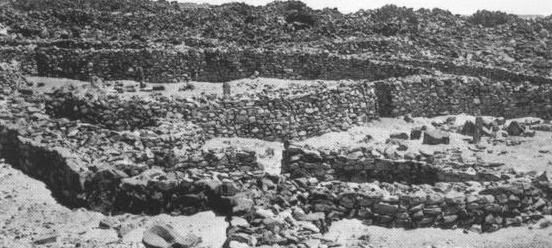
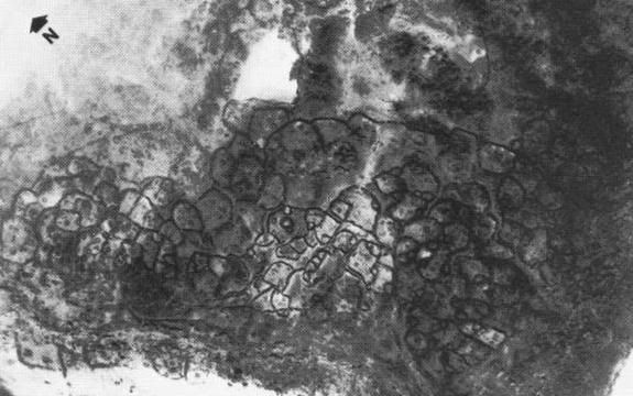
![[Smile]](smile.gif)


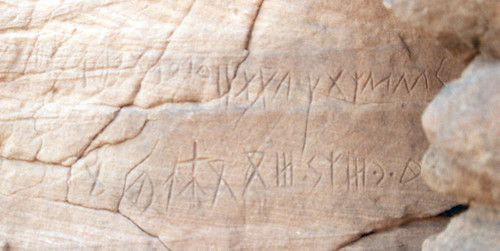


 Printer-friendly view of this topic