quote:Originally posted by Tukuler: Just to be clear I don't think Yam stretched into Temeh. Primary docs clearly distinguish Yam from Temeh. I don't necessarily see TC's map presenting hard and fast borders rather than territorial approximations. Maybe he'll tell us more about that map from its source?
I meant to say that Yam bordered Temeh. Perhaps the dispute between the two polities was about trade.
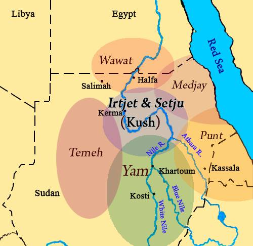
quote:Also I don't see the need for A or C groups anymore. We know the former is TaSeti and the latter Wawat. Same for Nubia when talking about peoples or polities when the specifics keep us from confusion. For me, Nubia is best reserved for geography to describe extreme south Egypt and northern Sudan or modern peoples known as Nubians.
Yes, force of habit on my part. When I refer to the archaeological groups I tend to use the 'old' labels. But you are right that it is more accurate to use the labels that the people or at least Egyptians used. Wawat is more accurate than "C Group".
quote:The following addressed not so much to DJ as to the forum. Academia translates (Ta)Nehesu as Nubia(ns). Problem is there were Nehesu living well beyond Nubia. Medjay and certain Intyw (Antiu/Troglodytes) for instance.
Point taken.
quote:This brings me around to Temehu and C Group. Once it's understood Wawat including Wawat's provinces, Irtjet, Satju, etc., was peopled by C Groupers then clearly Temehu have not a thing to do with being C Groupers. As far as my researching has lead me, at no time during the history of Ancient Egypt were Temehu ever Nehesu.
Oh, my point wasn't that C Group was synonymous with the Temeh but that there was a long and intimate history between them usually in the form of trade and certain cultural styles and borrowings between them which is probably why some past scholars postulated they were one and the same.
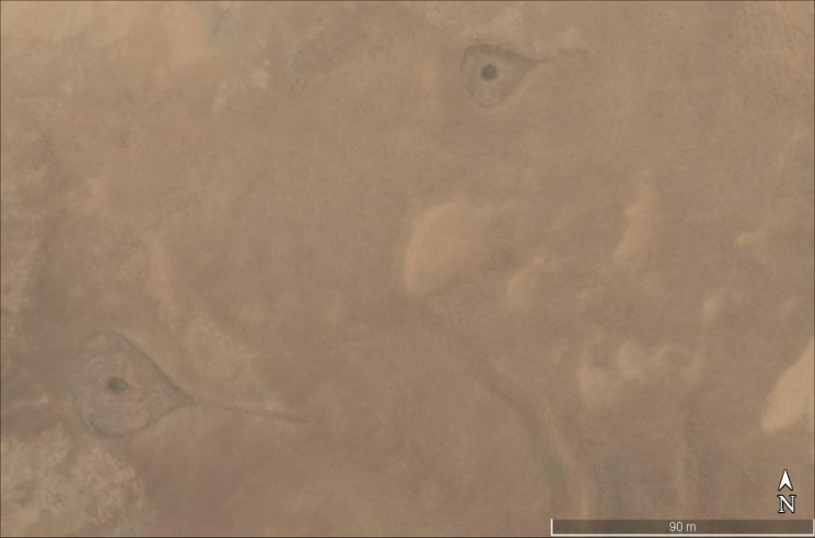
Figures 37 and 19 from Förster2006 Abu Ballas Trail Painted bowl, dated to the First Intermediate Period, from a tomb at the Qubbet el-Hawa near Aswan and a Rock engraving at Abu Ballas showing a Libyan (?) hunter with two dogs chasing a gazelle (photos: R. Kuper).
Again primary records from that era and later distinctly reckon Temeh as no part of those polities associated with Nehesi people.
Tukuler
multidisciplinary Black Scholar
Member # 19944
posted
DJ
Though my previous post was via reply to a post of yours its content was really more for the group.
I must say again that the terms I prefer to use are just that, my preference, and nobody need oblige the same usage.
The Temehu as C Group thing apparently confuses a lot of folk so I thought I'd just set the record straight from straight primary documentation that overrides all modern commentary suppositions.
6: Have you not considered how your Lord dealt with Aad 7: With Irem of lofty pillars 8: the like of which has never been seen in the Land? [Quran, Ch. LXXXIX, 6-14]
Hello guys. Recently I was during some more research on Yam and I stumble on this article about Irem in the Quran which was located in the southern Arabian peninsula. Irem was an earthly paradise in the Adytes Arabain history. I have learned here that Irem was in Sudan but there seems to be another Irem in a much more distant land possibly located in what is today Ethiopia/ Eritrea os southern Arabia. It appears Egypt Irem ( Yam) and Arabia Irem are two differnt cities, however I find it quite interesting that the simularites in the spelling.
Posts: 48 | From: US | Registered: Feb 2012
| IP: Logged |
Tukuler
multidisciplinary Black Scholar
Member # 19944
posted
Yes, there is a trans-Red Sea duality in TN"K too.
We find it in * Sennar-Shina (between the two Niles-Shinar between the Tigris & Euphrates), * Sheba and Dedan (one set from Hham and the other from Abraham), * Seba-Sheba (NE Afr-SW ArPen), and * Zerah-Zirrih (a Kushi king-an Arabian title of magnificence).
Thanks for adding Irem from Qur'an, one I never knew about before Posts: 8179 | From: the Tekrur straddling Senegal & Mauritania | Registered: Dec 2011
| IP: Logged |
posted
Sheba and Dedan (one set from Hham and the other from Abraham),
Thanks Tukuler and you are welcome. Could you explain more in detail about TN"K. Interesting recently I brought this to the attention of a friend and he was unaware of Irem in Arabia but speculated that Irem/Yam had an close association with Ham. I've even mentioned this to a Northern Sudanese friend of mine and he was unaware of it also.
Posts: 48 | From: US | Registered: Feb 2012
| IP: Logged |
Tukuler
multidisciplinary Black Scholar
Member # 19944
posted
As early as the days the story was first written by some Hebrew author, Sheba was a Two Shore empire spanning the straits of the Bab el Mandeb to include the Horn of Africa shore and the Arabian Peninsula shore.
There are three mentions of Sheba in B*reshiyth. One is in the linguistic territorial lineage of Hham. Hham (hot) indicates continental Africa. The other two mentions place Sheba in the linguistic territorial lineage of Shem, the belt of land parallel to the east Mediterranean shore, the Arabian peninsula and on to the eastward.
code:
   (Ham -> Cush -> Ra`amah                  -> Sheba and Dedan)

   (Shem      - -> `Eber      -> Joktan     -> Sheba)


   (Abraham                   -> Jokshan    -> Sheba and Dedan)
   (Abraham                   -> Midian)
The oldest Sheba is a continental African province and lineage. The next Sheba is Arabian peninsular as is the last and most recent Sheba.
quote:Originally posted by Tukuler: As early as the days the story was first written by some Hebrew author, Sheba was a Two Shore empire spanning the straits of the Bab el Mandeb to include the Horn of Africa shore and the Arabian Peninsula shore.
There are three mentions of Sheba in B*reshiyth. One is in the linguistic territorial lineage of Hham. Hham (hot) indicates continental Africa. The other two mentions place Sheba in the linguistic territorial lineage of Shem, the belt of land parallel to the east Mediterranean shore, the Arabian peninsula and on to the eastward.
code:
   (Ham -> Cush -> Ra`amah                  -> Sheba and Dedan)

   (Shem      - -> `Eber      -> Joktan     -> Sheba)


   (Abraham                   -> Jokshan    -> Sheba and Dedan)
   (Abraham                   -> Midian)
The oldest Sheba is a continental African province and lineage. The next Sheba is Arabian peninsular as is the last and most recent Sheba.
Yes, there is a trans-Red Sea duality in TN"K too.
Ahh!! okay after reading all your info yes I see now the connection and see what you mean by duality. When I first read the article which I presented here I notice this word Irem in the Quran. I knew there was a connction. Thanks
Hey Tukuler question could you help me with the translation of Yam in the ancient Egypt/Kemet writings. I have tried to decipher Iam/Yam on page one here in this thread but it is hard to see symbols. I am using the Garner dictionary but still have problems.
I would like to know how to write and translate it in the md.w nTr. If not can you lead me in the right direction. Thanks
Posts: 48 | From: US | Registered: Feb 2012
| IP: Logged |
Tukuler
multidisciplinary Black Scholar
Member # 19944
posted
quote: Originally posted by Akachi:
Tukler.. he has been here for over a decade, and is unwilling to disclose his opinion on the origins of Niger-Congo speakers and their context throughout the African story. What is wrong with that man?!
.
Man, know thyself
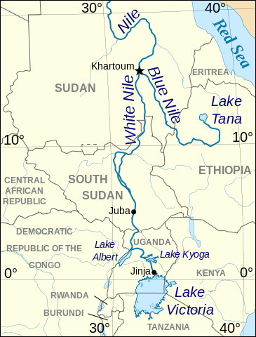
quote:Originally posted by alTakruri: Posted earlier, now zoomed and edited, this map shows a pre-historic route to Lake Chad from the Upper Nile Valley.
The same route in hemi-continental perspective probably goes back at least to the Sudan Neolithic and last Green Sahara phases.
The eastern terminals Dongola/Sennar to Darfur and Kordofan and then on to Lake Tschad and from there most likely up to Bilma for the track to the Niger's Bend and terminating at the Senegal may have some relation to the spread of the Niger-Kordofanian super phylum.
That is the "Sahel Route" established from times pre-historic and still in use today. It would've been used by Classical African Civilization folk to travel for trade or migration to West Africa.
The part of this route as far as Lake Tschad may also have to do with the two Afrisan phyla Chadic and Tamazight and maybe the Nilo-Saharan super phyum.
Above is the map I simplified and added the red undercores to, and on which you can follow the rest of the route from Kukiya on to the Senegal as well as see all the major historic trade routes from the Savannah to the Meditteranean and from the Red Sea to the Atlantic Ocean.
Posts: 8179 | From: the Tekrur straddling Senegal & Mauritania | Registered: Dec 2011
| IP: Logged |
6: Have you not considered how your Lord dealt with Aad 7: With Irem of lofty pillars 8: the like of which has never been seen in the Land? [Quran, Ch. LXXXIX, 6-14]
E: "Irem was an earthly paradise in the Adytes Arabain history".
Posts: 2021 | From: Miami | Registered: Aug 2014
| IP: Logged |
posted
Its possible that Yam was much larger than Egypt. Remember that College London Green Sahara simulation? Look at 3,900 BC when Egypt was trading with YAM. Is it time to revisit the Niger Pyramid? That thing seemed bogus with the 40,000 gold items that we never saw but that region was bustling in 3,900 BC. The simulation is based on archaeological sites and radio carbon data. Niger has more settlements than Chad. https://youtu.be/YOMFk_pi6tc?t=31Posts: 1254 | From: howdy | Registered: Mar 2014
| IP: Logged |
Tukuler
multidisciplinary Black Scholar
Member # 19944
posted
Bumped since ES is on a major Ancient Sudan revisit
posted
The most revealing of the inscriptions of these Aswan nobles relates to the life of Harkhuf, the famous caravan leader who served in the reigns of Merenre and Pepi II. He led four missions to the land of Yam, a region not yet identified but certainly beyond the Second Cataract to the south. Three of these expeditions were made during the reign of King Merenre and the fourth under King Pepi II. On the first journey Harkhuf and his father were commissioned to 'explore a road to Yam', a mission that took them seven months to accomplish. The second journey, which Harkhuf made alone, lasted for eight months. In this journey he took the Elephantine road (the desert road starting on the west bank at Aswan) and returned through Irtet, Mekher and Tererés. Here Harkhuf makes it clear that the lands of Irtet and Setu were under the jurisdiction of a single ruler. His third journey was undertaken along the oasis route. During this journey he learned that the chief of Yam had gone to Libya to conquer it. He followed him into that country and managed to appease him. He returned from this journey 'with 300 donkeys loaded with incense, ebony, oil, panther skins, elephant tusks, tree trunks and many other beautiful objects'. When he passed north through the territories of Irtet, Setu and Wawat, which were now united under one chief, Harkhuf was conducted by a military escort from Yam. On the fourth and last expedition Harkhuf brought back from the land of Yam a dancing dwarf for the young King Pepi II, who was extremely delighted with it.
-- N. M. SHERIF, Nubia before Napata (-3100 to -750), General History Of Africa II
Posts: 200 | From: Nibiru | Registered: Mar 2023
| IP: Logged |
I believe Yam was in the western desert in Darfur-Ennedi region rather than southern Sudan
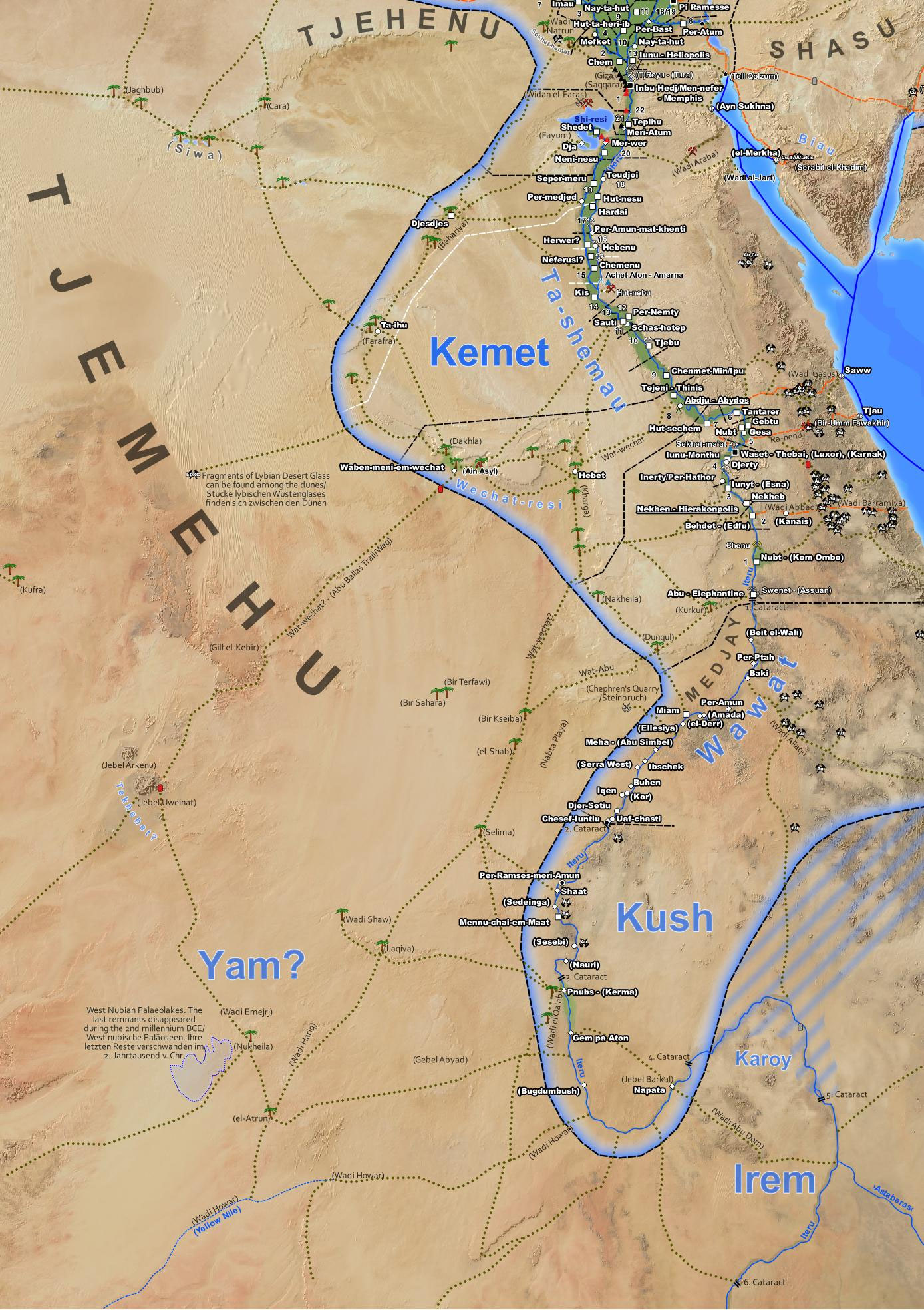
quote:An interesting, albeit puzzling, factor of Yam is its absence in documents, save topographical lists, after the beginning of the Middle Kingdom...There are a variety of speculative and hypothetical scenarios one can put forth to suggest its elimination from the textual record. The equation of Irm and ImA suggested by Priese is one possible scenario; therefore Yam no longer existed under the same name. Another possibility is that the toponym ceased to be relevant to the Egyptians... A more compelling scenario is that the desiccation of water sources had rendered access to Yam impossible, or possibly the changing ecology threatened Yam itself.
Furthermore, the absence of Yam in texts in the Twelfth Dynasty and later would concord well with the abandonment of the Abu Ballas trail in the Middle Kingdom,which perhaps was also rendered impassable from the changing ecology...This argument of course does not aim to suggest, with any certainty or precision, a location for Yam within a finite area. Rather it argues that a Western Desert location of Yam, near the Gebel Uweinat, or Ennedi, concords well with much of the textual and archaeological evidence.Broadly, the evidence suggests that Yam could be approached by going west and south from Egypt, via the oases and Abu Bal-las trail, or south and then west via the Nubian Nile and North West Sudan.The evidence is certainly too ambiguous to support a Nubian location and to construct arguments based on this location would be hazardous and premature. Such previous attempts at localising Yam reflect a broader tendency to place many unknown southern toponyms on the Nubian Nile, with little or no evidence specifically favoring such locations. Like the Nubian Nile, the Western Desert was also part of a complex trade net-work in the Third Millennium B.C.This western theatre may have been the origin of many of Egypts exotic imports, which hitherto were only expected from the Levant, Nubia, and Punt.
-- Julien Cooper, 'Reconsidering the Location of Yam', Journal of the American Research Center in Egypt 2012
quote:Perhaps the earliest documentary evidence for trade between Cush and Därfür comes from inscriptions on the tombs of Egyptian kings of the Vlth Dynasty. In their time, especially under Mernere and Pepi II, caravan leaders made several journeys south-westwards to the kingdom of Yam and the land of Temeh which Arkell identifies with Därfür and Tama respectively.
(Harkhuf's)escort from Yam demonstrates the existence of regular contact between Tama, Därfür and Ennedi on the one hand and Cush on the other.
Seven hundred years later, another Egyptian king, Tuthmosis IV, raided the territories of the Irm, Gwrss and Trk, names which are associated with Därfür. Egyptian kings of the XXVth Dynasty who originated from Cush, would have consolidated trade with that region which they may have annexed to Cush.
J.A. Ilevbare, Potential contact between the central valley of the Nile and the River Niger area in the first seven centuries of the Christian era, Libya Antiqua
quote:Originally posted by Djehuti:
Yam neighbored Pygmy territory or perhaps had Pygmies living in its southern area.
quote:The Egyptians were already in touch with Africa south of the Sahara, and that the 'Nubian Corridor' played an important part in these contacts. Under Pepi II, an Egyptian expedition brought back from the distant south a 'dwarf for the sacred dance'. The word used to describe this person is deneg, whereas the usual term employed for a dwarf in the hieroglyphic texts is nemu. We might well wonder and the answer is likely to be positive, whether deneg refers in fact to a Pygmy.
If this is so... the Egyptians of the Old Kingdom must have been in direct or indirect contact with this race from the equatorial forest. Even if the Pygmies' habitat extended much farther north than it does today, which is possible and even likely, because of the different climate during the third millennium, this area would still have been very far to the south of Nubia. We can therefore conclude that the Egyptians of the Old Kingdom had contacts with Central Africa, and that Nubia and its inhabitants did much to make such contacts possible.
S. Adam, J. Vercoutter, The importance of Nubia: a link between Central Africa and the Mediterranean, General History Of Africa II
Posts: 200 | From: Nibiru | Registered: Mar 2023
| IP: Logged |
posted
^ Yes that theory of Yam being located west of the Nile was discussed also. It's just that unfortunately archaeologists still haven't found Yam and only know of inferences from Weni and Harkhuf's expeditions.
quote: Sometime in the early Sixth Dynasty, Egyptian records indicate contact with specific regions and peoples located to the south, some previously known only by the larger geographic designation Ta-Seti, or Land of the Bow, or Ta-Nehes, Land of the Nubian. While these appear as names for the first time, it is clear that they were well established, and had been in place for some time. They occur both in contexts where persons were assigned to regulate conracts16 and where there was active fieldwork involved, notably the recruiting of soldiers and travel to foreign lands. The places and peoples have occasioned a good deal of discussion with various locations being proposed for some of them, while ochers are well-known and located. At this point we deal with a tendency in Egyptology to underestimate the reach of Egyptian engagement in Africa, which has recently been confronted by evidence chat the country called was truly far away. Following are the more important lands, as mentioned in the principal documents, of Weni and Harkhuf, which give some geographical perspective:
WAwAt: Later established as the name for Lower Nubia from the First to the Second Cataract, it probably roughly corresponded to that territory.
IrTt: Linked in order with and in a single polity by the time of Harkhuf's Third Journey, it may have been the southernmost of the three, although the order of and may not be geographical in relation to Egypt.
SaTjw: Linked in a polity with Irtt Wawat.
Makhr: Mentioned once, reached from the Elephantine road, apparently above and Satjw.
Trrs: Mentioned once, reached from the Elephantine road, apparently above Irtt and Satjw.
Kaaw: Mentioned only by Weni, its relationships are uncertain.
Tmh: Associated later with Libya, it was the objective ofa campaign by the chief of Iam, which Harkhuf interrupted.
Iam: As che main objective of Harkhuf's expeditions, Yam has received considerable discussion. It has been assigned locations from the southern Libyan Desert (oases) to Kerma, to the Isle of Meroe, based on Harkhuf's statement that it took a long time to get there and return to Egypt and Harkhuf's mention that he was exploring a road to Yam in one instance, taking the Elephantine Road in another, and thirdly the Wehat (oasis) road. Some fairly elaborate and well-formed estimates involving time, distance and original starting points have been brought to bear on the question, a number of them starting Harkhuf from Memphis by donkey in order to use up the seven or eight months required.
Medja: Well-known from Old through the New Kingdoms, Medja is widely associated with the Eastern Desert. For the Old Kingdom, scholars have argued variously for a location east of Upper Egypt or as far south as the Second Cataract. If the Egyptians had been faring as far south and west as Darfur in the west, and as far south as Punt in the east-both difficult, time-consuming, and hazardous journeys-- is there any reason to limit Medja so severely? Later, Sobeknakht II recounts that Kush mustered forces from Medjay and Punt, which would indicate that they were adjacent. This would imply chat Medja had much the same location as the Bedja do today, occupying the Eastern Desert from about the Wadi Hamamat to the Ethiopian highlands. Given that this area is larger than the Levant, diversity is to be expected.
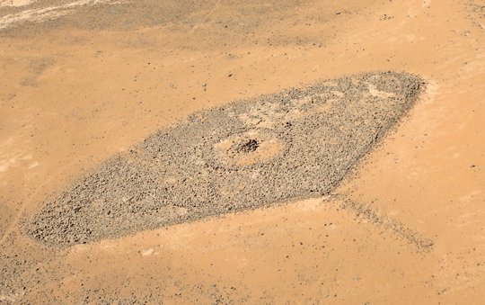
quote:The discovery of an inscription at Jebl Uweinat gives a reason to reconsider the geographical location of the country of Yam. This has to take into account the relationship of Yam to the area of Wawat in Lower Nubia and to the Tjemehu people in the Western Desert of Egypt. Two centres are proposed for Yam, the fortifications called Djedefres Water Mountain and Gala el Sheikh. Both are characterized by so called water mountain symbols. The people of Yam were vassals of the Egyptians and assisted them to get into contact with other people between west and south. This includes the people of Tekhebet, who may have been the builders of the compass graves in the Tibesti and its neighbourhood.
quote:Cooper (2012) suspects Tekhebet, a suggestion by Clayton et al. (2008:131) next, near Jebel Uweinat. He places Jam in the area between Jebel Uweinat and the Paleo-Lakes in NW Sudan, of which Nukheila/Merga remains to this day (2012: Fig. 1). He thinks that on his second journey Harkhuf entered the territory of Nukheila from Elephantine (Aswan) via Kurkur, Dunqul, Selima and Laqiya Arba'in. The return journey would then be via Wadi Hariq ("burnt Wadi", so called by archaeologists because of strong burn marks and fried sediments; Lange, 2007; Jesse, 2007: Figs. 6-7) to the Nile at Kerma or alternatively further south along the Wadi Howar gone to the Nile at Old Dongola. From there the route went down the Nile to near Amarna West and then back to Elephantine.
quote:The Egyptians had several terms for people of short stature, dng and nmw (= nemu). Both pygmies and chondrodystrophic dwarfs were depicted. They were dancers, companions of their masters with dogs and monkeys, valets. The pathological dwarfs were also goldsmiths. In the Middle Kingdom, the pathological dwarfs were only referred to as nmw. Later, dwarves were replaced by the Bes figures. The Egyptian word dng for "dwarf" is cognate with the analogous words dink, dinki (Cushitic), dinkō (Omotic), dank (Amharic), denki-t
Because of the similarity of the Egyptian term dng (deneg) for the dwarf with the term in southern languages, because of the parallels in their meaning in kingship, and because of geographical accessibility, the dwarf Harkhoof probably originated in southern Ethiopia and was acquired through middlemen.
quote:The Jam belonged to the Nehesyu, the southern peoples. They were known in Egypt at the latest by the time of Merenre (2283-2278 BC), i.e. before the advance of dark-skinned people northwards in the Nile valley. They were probably racially related to the Egyptians, like the people of Group A. This may also apply to their language.
quote:If we accept that the land of Jam lay beyond Wawat in present-day Nubia as seen from Egypt, and that no other sites than those indicated were touched on the way there (O'Conner, 1986), the location of Jam is Wadi el Qa'ab. This is not a wadi in the sense of a dry river, but rather a depression running roughly north-south parallel to the Nile valley along its western bank, roughly from the geographic latitude of Kerma to a latitude south of Dongola.
quote:How did the jam people come to Jebel Uweinat?They probably supported the Egyptians in laying out the donkey path from Balat to Jebel Uweinat, or they laid out the western part themselves beforehand. About 50-80 km away to the E and SE of Jebel Uweinat there are some isolated flat-topped hills that have a ring at the top like a simple fortification. One or more may have been temporary camp sites for the jam people. A direct connection from Jebel Uweinat to Gala el Sheikh is difficult to imagine, since the waterless routes are probably too long for donkeys. Donkeys with loads are documented in the rock art at Jebel Uweinat. The area between Selima and Nukheila may also have belonged to Jam or inhabited by other peoples. This speculation would allocate a very large area to the people of Jam. The connecting link are the water mountain symbols. The mortarless construction method is not specific to the Jam people, as it has also been used on other structures, e.g. at Gala Abu Ahmed with a trapezoidal plan in Wadi Howar and at the square fort at El Kueibi about 35 km SW of Gala el Sheikh.
quote:Tekhebet is not otherwise mentioned in Egyptian literature. The country was probably remote. The compass tombs can possibly be assigned to its inhabitants. Figure 16 shows such a situation. The donkey trail from Balat to Jebel Uweinat is marked. This interpretation can only be proven if further Egyptian inscriptions or archaeological documents are found that confirm it.
- Berger, F. (2018): Neue Überlegungen zur geographischen Lage von Jam
Posts: 200 | From: Nibiru | Registered: Mar 2023
| IP: Logged |
posted
^ I agree that Iam/Yam likely lay somewhere in the Western part of Sudan which at that time was still verdant and not desert. The routes cited do show a direction in a western area parallel to the Nile and not along the Nile itself. This explains why the ruler of Yam had conflict with specifically the Temehu. Also, there are records that the natives in pre-Kerma (pre-Kushite) Central Sudan was hostile to Egypt so Harkhuf and other traders could not pass through there and I don't think Temehu territory stretched that far south. The Egyptian records indicate Temehu lay along the Western Desert parallel to Upper Egypt and perhaps into Lower Nubia but not unto Upper Nubia.
This also explains why Yam has closer proximity to what is today the Central African African Republic.
-------------------- Mahirap gisingin ang nagtutulog-tulugan. Posts: 26267 | From: Atlanta, Georgia, USA | Registered: Feb 2005
| IP: Logged |
posted
If we are to locate Yam in the desert west of the Sudanese Nile, I really want to see if we can find any archaeological traces of their culture. Surely there are ruins, graves, and artifacts of interest in that region.
posted
^ Unfortunately most of the archaeology is confined to the river valley areas, not to mention that military conflict in the the western deserts of Sudan (like Darfur) make archaeology impossible at the moment.
-------------------- Mahirap gisingin ang nagtutulog-tulugan. Posts: 26267 | From: Atlanta, Georgia, USA | Registered: Feb 2005
| IP: Logged |
quote:For some time, Kerma was thought to be the country of Yam, ultimate destination of the expeditions by the Elephantine governors in the late Old Kingdom, but with the discovery of Mentuhotep IIs inscription at Jebel Uweinat this important place must have been located far to the west, at least in Darfur, or even modern Chad. Instead, Old Kingdom rockgraffiti at El-Kab Oasis seem to indicate that the Dongola Reach area may have been on a different route, most likely the return road from Yam, making a kind of triangle, with the outward journey using the Abu Ballas trail, and the heavily laden return using the Wadi Howar to the Nile area and northward. Several names appear for the Nubian region in the records, and only Wawat, designating Lower Nubia, is known. Of the others, perhaps Irtjet, the most prominent, would indicate the Kerma area, but that is only a guess. If so, then by the third journey of Harkhuf, the region from Kerma to the First Cataract had one ruler. More important, since the records refer to several territories and rulers, it appears likely that authority in the KA culture area became divided, while Wawat, the territory north of the Second Cataract, was apparently more united. It should be noted, however, that if the great temple (Deffufa) in the city at Kerma was first built in KA, it was already monumental and may already have been the leading power. Thus, already, large districts south of Egypt were consolidated politically. In addition, however, Egyptians claimed to have campaigned in all the Nilotic Nubian regions and Yam, surely an immense field of political engagement and projecting power. It is telling that when Weni assembled an army to attack the Sand-Dwellers (Asiatics), he did so with troops from Medjay, Yam, Wawat, Irtjet, Kaau, and Tjemehuindicating a wide reach of power into the south, east, and westand that Harkhuf used a troop of Yam to overawe the rulers of the Nile valley on one of his returns.
- Bruce Beyer Williams, The Oxford Handbook of Ancient Nubia, 2020
quote:Originally posted by Djehuti:
...there are records that the natives in pre-Kerma (pre-Kushite) Central Sudan was hostile to Egypt so Harkhuf and other traders could not pass through there and I don't think Temehu territory stretched that far south.
quote: The Tjemehu-Libyans are therefore located to the west of Upper Egypt where the recently documented Abu Ballas caravan trail led from the oasis of Dakhla to the high plateau of the Gilf Kebir and the Jebel Uweinat and maybe further into the Chad basin of Central Africa.
- Thomas Schneider, Language Contact in Ancient Egypt, 2023
quote:Originally posted by BrandonP:
If we are to locate Yam in the desert west of the Sudanese Nile, I really want to see if we can find any archaeological traces of their culture.
quote:Originally posted by Djehuti:
^ Unfortunately most of the archaeology is confined to the river valley areas, not to mention that military conflict in the the western deserts of Sudan (like Darfur) make archaeology impossible at the moment.
A.J Arkell held many excavations in the region but more so related to Kanem-Borno, Ouaddaï, the Keira dynasty etc although he did unearth some things pertaining to Nubia. Wether texts referring to Yam had even been discovered during his work idk
quote:Originally posted by BrandonP:
Surely there are ruins, graves, and artifacts of interest in that region.
There are the compass graves as mentioned above which may be associated with either Yam or Tekhbet but they've never been excavated and there doesn't seem to be any literature on them at all
Is anyone familiar with the "Sheikh Muftah culture"? and whether there is any link to any of the later sites in the region?
Posts: 200 | From: Nibiru | Registered: Mar 2023
| IP: Logged |


 UBBFriend: Email this page to someone!


 Printer-friendly view of this topic