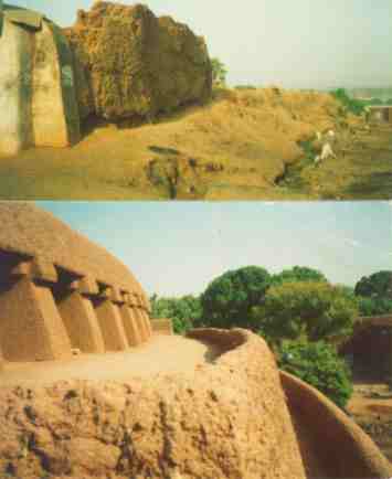
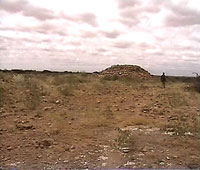
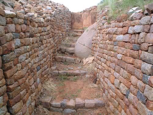
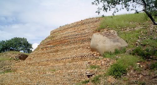
Reminiscent of old Zimbabwe far to the South of Africa is these ruins in Burkina Fasso West Africa they link the gold producing cities to the south of the savanna empires had contacts to the forest empires like the Ashanti and others.
Wow awesome. Although I really wish Great Zimbabwe was preserved better. Explorers tore that place apart trying to find evidence of Phoenicia civilizing them
Thanks for da link
Posted by Brada-Anansi (Member # 16371) on :
Calabooz African archeology is still in it's infancy there are hundreds of sites like this scattered through out Africa only funding and lack of general interest caused places like this to be hidden in plain sight.
Posted by Just call me Jari (Member # 14451) on :
Nice Find Brada!!
Posted by Brada-Anansi (Member # 16371) on :
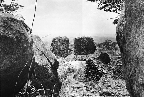
Thanks Jeri but like I said African archeology is still in it's infancy case in point in Sierra Leon we have the Yegala ruins but nothing is known about them despite the site being abandoned at the turn of the last century,it's ashame that some of us with mad skills and education spend so much energy fretting about ancient blacks in far off Asia,Europe and the Americas but will not look in the lands of their most immediate ancestors. Remains of a stone-walled house at the deserted hilltop defensive site of Yagala, Sierra Leone (West Africa) Posted by Just call me Jari (Member # 14451) on :
^^^ So True, Take the following Psuedo-Scholarship for example...
Egypt, Sumer, Persia, MEsopotamia, Indus Valley, Thailand, Europe, the Olmec, yet nothing on Oulata, Nok, etc. Its sad and even worse reflects on people like you and me who want to represent Africa not the Olmec or Thailand or China.
Pathetic really..
Posted by AGÜEYBANÁ(Mind718) (Member # 15400) on :
quote:Originally posted by Brada-Anansi: Thanks Jeri but like I said African archeology is still in it's infancy case in point in Sierra Leon we have the Yegala ruins but nothing is known about them despite the site being abandoned at the turn of the last century,it's ashame that some of us with mad skills and education spend so much energy fretting about ancient blacks in far off Asia,Europe and the Americas but will not look in the lands of their most immediate ancestors.
Lol @ giving them props for having mad skills, I don't agree, maybe the perseverance but not the skill.
quote:Originally posted by Just call me Jari: ^^^ So True, Take the following Psuedo-Scholarship for example...
Egypt, Sumer, Persia, MEsopotamia, Indus Valley, Thailand, Europe, the Olmec, yet nothing on Oulata, Nok, etc. Its sad and even worse reflects on people like you and me who want to represent Africa not the Olmec or Thailand or China.
Pathetic really..
Exactly
Posted by The Explorer (Member # 14778) on :
quote:
Estimated age?
Posted by Brada-Anansi (Member # 16371) on :
11th century A.d Explorer
quote:Estimated age?
Posted by Sundjata (Member # 13096) on :
Thanks Brada-Anansi!
quote:Originally posted by Brada-Anansi: Reminiscent of old Zimbabwe far to the South of Africa is these ruins in Burkina Fasso West Africa they link the gold producing cities to the south of the savanna empires had contacts to the forest empires like the Ashanti and others.
Goodness, how much history can be hidden?! What's interesting is that it can't be associated with any particular ethnic group/kingdom. Given that, I wonder what they've used to narrow down the range of time in which this structure was built as the writer/s seem to contradict themselves:
quote:The recent inter-disciplinary project has allowed a reassessment of the history of Loropéni. This has pushed much further back the date of its construction from around the 17th century to at least the 11th century AD and disassociated it from the Gan people, mentioned in the previous evaluation report.
quote:It is necessary to locate the construction of the Loropéni ruins in the geopolitical context of the sub-Saharan kingdoms. They appeared after the fall of the first empires of Ghana, Mali, and Songhai, when there were migrations of gold miners and goldsmiths into the Lobi area, and well before the development to the south of the Akan kingdoms, such as the powerful Ashanti kingdom, which caused migrations to the north as people fled slave hunters
^ But if it can be pushed back to the 11th century then that is well before the emergence Mali and Songhai. The introductory description also claims the ruins are 1,000 years old, "AT LEAST" and that the town reached its apogee between the 14th and 17th century. This is roughly congruent with the rise and fall of Old Mali. Maybe they're referring to the Gan's "rebuilding" project as was alluded to.
It would be interesting to scan the archaeology and present ethnography to see if we can identify any similar building traditions preceding Loropeni and if any other groups likely remember it (as the Koulango say they do).
Posted by Brada-Anansi (Member # 16371) on :
Maybe we have to look at these people
quote:the most recent research shows that the Koulango were preceded by Lorhon and Nabé peoples who migrated south into the area and were known to be in the area of Kong, from the 10th century
I think the trees growing out of the ruins help to narrow it down to at least the 11th century.
Posted by TruthAndRights (Member # 17346) on :
give thanks for this thread....we need more threads like this Posted by rahotep101 (Member # 18764) on :
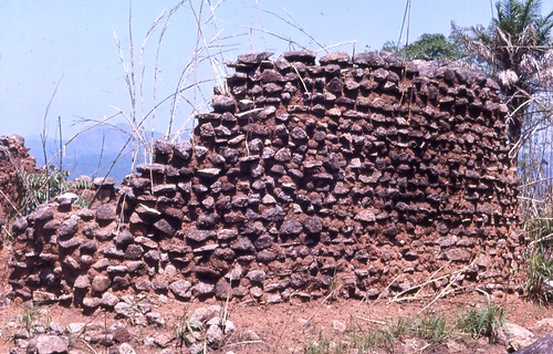
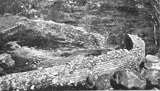
Sorry, but the title of this thread caused me to expect more than that. That's not a stone city, that's a tumbledown garden wall made out of pebbles! There's not a cut stone in sight! This is what you call a stone city ruin: Posted by adrianne (Member # 10761) on :
the point is , did u even know it exsisted
NO,
the rest of us r thankful to brad for showing us more information on africa some of us didnt know.
Posted by Sundjata (Member # 13096) on :
quote:Originally posted by rahotep101: Sorry, but the title of this thread caused me to expect more than that. That's not a stone city, that's a tumbledown garden wall made out of pebbles! There's not a cut stone in sight! This is what you call a stone city ruin:
This isn't a competition. Anyone can throw up for comparative purposes one of the most grand towns in medieval Syria to contrast with this rather isolated and previously unknown site of stone masons, likely fleeing climate changes and/or chasing better mining opportunities.
You and Jari have gone over this, a better comparison would be with the contemporary polities from which this site radiated, or with reference to Syria, with contemporary towns outside of Almyra that were less important commercially and/or more isolated (they'd likely look very similar).
My theory is that Loropeni is a settlement likely built by the Dyula gold traders (who are still found in Burkina Faso) who of course would have had extensive influence during the Mali empire, when the town saw its zenith.
Ignoring your picture spam, and while acknowledging Syria's architectural accomplishments, it is necessary to provide some context here as to what the Syrians, whom you throw under the bus to spite the Loropenians, actually said about the region:
Mahmud Ka'ti, medieval Syrian scholar on Mali:
quote:"Among the kingdoms of the rulers of the world, only Syria is more beautiful. Its inhabitants are rich and live comfortably".
^So yes, you purposely left out Europe because most in Europe at this time were living in squalid conditions during the height of the dark ages. Using Syria as a proxy to boost your self-esteem would have been smart, were it not for the Syrians themselves praising Mali (in which Loropeni was incorporated during its apogee) as being among the most beautiful kingdoms in the world, only behind Syria! Posted by The Gaul (Member # 16198) on :
quote:Originally posted by rahotep101: Sorry, but the title of this thread caused me to expect more than that. That's not a stone city, that's a tumbledown garden wall made out of pebbles! There's not a cut stone in sight! This is what you call a stone city ruin:
Your low self-esteem is showing.
Posted by Just call me Jari (Member # 14451) on :
Good Work Sundjaita. This clown with an African deity as his moniker needs to keep the myth of an inferior Africa to bolster his mindset and out look on African people. As I said before he does'nt care about Egyptians, he only cares because the Delata Egyptians resemble him, and his belief of "Caucasoid Syrians" founding Egypt that Kalonji Debunked here..
^What's also ironic is that the best architecture/stone masonry in Europe around this time would have been created by Moors.
Posted by Brada-Anansi (Member # 16371) on :
Guys haters gotta find some thing to hate about thats their job,but actually we are lucky because in moist areas like that many remains would completely vanish
And yes we are thankful for those "garden walls" how majestic and unique they must of been in their hay day, not only that, but that "Garden Wall" is right smack in the middle of so-called kneegrow country a place Rahotep and his ilk would claim could never possibly construct anything but the much maligned mud huts.
I bet the Sahara also is yet to reveal most of it's secrets,as well as the forest zones but urbanization in West Africa were contemporary with the 1st dyn kings of Kemet,the above Dhar tichitt Not saying there is a connection between the two sites but Africans build in stone when materials is available they use Adobe styles when confronted by the desert.
Ancient Kano at it's hight it must have been an awesome "garden wall"
Posted by Brada-Anansi (Member # 16371) on :
The Kirikongo Archaeological Project
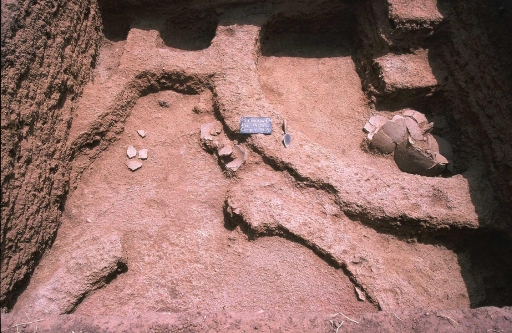
A 3 x 3 m test unit was excavated at mound 1. The location was chosen for two reasons. First, the height of the 3.5 m mound suggested a long occupational history; and second, the mound is in danger of destruction due to its proximity to the road. The unit exhibited excellent preservation of various classes of materials. Since an aim of the project is to discriminate various social units at the site, preservation is essential for isolating key spatial variation as well as for a detailed analysis of socio-economic data. Parts of 6 superimposed household compounds were uncovered throughout the sequence. In some, the mud-brick walls stood 20-30 cm high, and measurements on individual bricks were possible. Materials were collected according to various spatial contexts within each compound. For example, it was possible to sample a paved interior courtyard and three different mud-brick structures in compound 3 (Figure 3). The excellent architectural preservation was mirrored in manufactured objects and subsistence remains. All deposits were screened and flotation samples were taken from all primary contexts. Preliminary analyses of subsistence data (botanical and faunal) are currently underway to characterize the economy. Kirikongo is a successful village founded in the early first millennium AD and most likely abandoned ~ AD 1400. With the establishment of an occupational chronology it will be possible to model the development or foundation point of various mounds within the group over time. In order to analyze social dynamics, it is necessary to establish contemporaneity between component parts
I hope you guys are not making the mistake of judging African cultures by Western standards.
Many African cultures built cities; however very few of them were constructed by stone. In African cultures, large monuments and structures constructed of permanent and endurable material such as stone was built for spirits of the dead or the gods and meant to last for eternity, whereas large monuments and structures constructed for living yet mortal people were constructed of more temporary and perishable materials such as adobe (mud-brick) or wood.
The same was true for ancient Egypt, where most of the stone monuments in the form of temples and tombs were dedicated to gods and pharaohs. Virtually all cities in Egypt were constructed of mud-brick and wood and even then such cities were few and far between throughout the country of Egypt. This is the reason why Egypt was popularly called by archaeologists a civilization "without cities". Ironically, West Africans built many cities yet their civilizations tended to be ignored by Westerners as part of propaganda to demoralize and denigrate them.
Posted by TruthAndRights (Member # 17346) on :
quote:Originally posted by Djehuti: I hope you guys are not making the mistake of judging African cultures by Western standards.
Many African cultures built cities; however very few of them were constructed by stone. In African cultures, large monuments and structures constructed of permanent and endurable material such as stone was built for spirits of the dead or the gods and meant to last for eternity, whereas large monuments and structures constructed for living yet mortal people were constructed of more temporary and perishable materials such as adobe (mud-brick) or wood.
The same was true for ancient Egypt, where most of the stone monuments in the form of temples and tombs were dedicated to gods and pharaohs. Virtually all cities in Egypt were constructed of mud-brick and wood and even then such cities were few and far between throughout the country of Egypt. This is the reason why Egypt was popularly called by archaeologists a civilization "without cities". Ironically, West Africans built many cities yet their civilizations tended to be ignored by Westerners as part of propaganda to demoralize and denigrate them.
!!!!!!!!!
Posted by Brada-Anansi (Member # 16371) on :
Yet this site was known since at-least 1910 but info never got to the general public,I know it is a financial burden for many African nations to carry out their own archeological surveys to preserve their histories especially when more immediate needs must be taken care of, but a way must be found for the good of generations yet unborn.
Posted by Sundjata (Member # 13096) on :
quote:Originally posted by Djehuti: I hope you guys are not making the mistake of judging African cultures by Western standards.
Many African cultures built cities; however very few of them were constructed by stone. In African cultures, large monuments and structures constructed of permanent and endurable material such as stone was built for spirits of the dead or the gods and meant to last for eternity, whereas large monuments and structures constructed for living yet mortal people were constructed of more temporary and perishable materials such as adobe (mud-brick) or wood.
The same was true for ancient Egypt, where most of the stone monuments in the form of temples and tombs were dedicated to gods and pharaohs. Virtually all cities in Egypt were constructed of mud-brick and wood and even then such cities were few and far between throughout the country of Egypt. This is the reason why Egypt was popularly called by archaeologists a civilization "without cities". Ironically, West Africans built many cities yet their civilizations tended to be ignored by Westerners as part of propaganda to demoralize and denigrate them.
What I've learned is different about African towns is that many were indeed made out of more perishable material. For example, what we know most about the Swahili towns are the marvelous stone ruins, however, recall when Ibn Battuta traveled to the Swahili coast he described houses and structures that were made of wood.
Also, polities through out central Africa had traditions where whole cities were even relocated due to the ease of deconstruction and reconstruction with such perishable materials during famine or war. There are no signs for example of Buganda in the state it was in when first depicted by the Portuguese, but it is preserved in illustration.
I was watching a documentary in one of my classes which brought up a good point. The documentary shows the simple construction of a bridge by the Biaka that took three days to construct and after it was used, the bridge was destroyed. The question was posed asking how old the technology was and what evidence can we use to indicate this? The thing is, the materials used to build the bridge, basic rope, would disintegrate over time to the point where there'd be no trace of the material or material found wouldn't be recognized later as an component of an ancient bridge.
Perishable material is a big problem in archaeology. It seems Africans may have been big on using these kind of materials due to hostile/diverse environments and different resource availability, such that much of the architecture and technology from certain regions are lost. The Great Mosque at Djenne for instance is retouched every year so imagine the resilience (or more correctly, lack of resilience) of an abandoned site made from mostly perishable materials.
There is a ton of work and a million more things to find within Africa through the archaeology. It is like a new frontier right now. I'm just glad to hear of Loropeni, it is actually a pretty big discovery IMO and should provide a lot more data for a better understanding of the dynamics occurring in the West African Sahel zone (and the regions straddling south of the Sahel) around this time.
Posted by The Explorer (Member # 14778) on :
African complexes used a variety of building materials, and their extent of use varied from complex to complex, depending on the location of the region, availability and type of primary building material, nearest accessible trade network, and personal wealth of homeowners. There is no unison
Courtesy of Ray A. Kea,
According primary historic texts...
Al-Bakri gives a description (1068) of the royal capital:
The city of Ghana consists of two towns situated on a plain. One of these towns, which is inhabited by Muslims, is large and possesses twelve mosques, in one of which they assemble for the Friday prayer. There are salaried imams and muezzins, as well as jurists and scholars. In the environs are wells with sweet water, from which they drink and with which they grow vegetables. The kings town is six miles distant from this one and bears the name Al-Ghaba. Between these two towns there are continuous habitations. The houses of the inhabitants are of stone and acacia wood. The king has a palace and a number of domed buildings all surrounded with an enclosure like a city wall. In the kings town, and not far from his court of justice, is a mosque where the Muslims who arrive at his court pray. Around the kings town are domed buildings and groves and thickets where the sorcerers of these people, men in charge of the religious cult, live . The kings interpreters, the official in charge of his treasury and the majority of his ministers are Muslims (Levtzion and Hopkins 2000: 80).
From archaeology...
Kumbi Saleh:
The Koumbi Saleh tumulus has a circumference of 2.4 kilometers and occupies 44 hectares of land. It was formerly surrounded by a wall, most of which is no longer traceable on the ground, but vestiges of its monumental gate are still visible. Remnants of other encircling walls suggest either different stages of fortification development or a city fortified by a double- or triple-wall defense system. Within the walls, the city was densely built up on higher and lower elevations. Archaeologists have identified three principal thoroughfares as well as numerous narrow, straight streets and a large square, which probably served as a market, and many small squares. These public spaces demarcated the sixty blocks of single- and multi-story stone houses on the citys higher elevation. Rows of shops connected to the houses street fronts opened onto the streets. In this section of the city (measuring 700 by 700 meters) were located the royal palace and the residences of officials and rich merchants. Surrounding the elevated quarters is the citys lower section (measuring 500 by 700 meters).
Awdaghast:
Level 1, 7th8th century: mud brick housing predominates and the first stone buildings were constructed; metal working (particularly in iron, copper, and gold) and local pottery production were important; glazed pottery imported from the Maghrib appeared in great quantity; Kharijite (Ibadi) traders in residence.
Level 2, 9thlate 10th century: in the second half of the 10th century the town is reorganized with the laying out of streets and public squares; an artisans quarter is organized; multi-story stone houses built around courtyards appear in the upper town; luxury goods from the eastern and central Maghrib were imported in huge quantities (glazed pottery of all kinds, glassware, jewelry in gold, silver, copper, brass, and semi-precious stones); the metal working and the pottery industries flourished; beginning of glass bead production.
Level 3, late 10th11th century: multi-story stone houses continue to be built but their architectural styles are transformed; crafts (e.g., weaving, metalworking, bead and pottery making, and leather working) are carried out on a huge scale in the artisans quarter; glass weights were common and gold ingots were cast; deforestation is evident by the first half of the 11th century; part of the city, in particular the artisans quarter, was destroyed by the Almoravids (1054) and was partially abandoned; imports from the Maghrib and al-Andalus remained constant.
Level 4, 12th13th century: the artisans quarter was reorganized on a smaller scale; glass bead production prospered until the end of the 12th century; metal working activity declined significantly but the production of pottery and leatherware continued unabated and fl ourished; new pottery patterns were introduced; quality of domestic architecture changed (latrines introduced; interior of stone houses painted); a small mosque was built in the 13th century imports from the Maghrib and al-Andalus continued throughout the period but modestly compared to earlier times, suggesting that traders were bypassing the city...
Nice updates Explorer I 'll be raiding your blog for info and updates of my own,all this give lie to those would say complex buildings in Africa especially West Africa had something to do with Arabs or 19th cent Europeans..btw please make use of this thread for your own blog.
Posted by Djehuti (Member # 6698) on :
^ Yes, and notice the Euronuts are totally silent in this thread. It must be nice to ignore reality when it doesn't suite one's fancies.
quote:Originally posted by The Explorer: African complexes used a variety of building materials, and their extent of use varied from complex to complex, depending on the location of the region, availability and type of primary building material, nearest accessible trade network, and personal wealth of homeowners. There is no unison.
Yes, I agree Explorer. I didn't mean to generalize, but I was raising a valid point about not basing advanced cultures on Western models or that many cities in Africa were built using perishable material. That cities of stone were built and used by living people is a given and may all the more evidence be shown, please.
Posted by Brada-Anansi (Member # 16371) on :
DJ let em remain silent,remember their agenda is not to learn or seek truth above all else but to lie and distort.
and notice the Euronuts are totally silent in this thread. It must be nice to ignore reality when it doesn't suite one's fancies. Posted by IamNomad (Member # 17656) on :
Wargaade Wall is an ancient stone construction in Wargaade, Somalia that enclosed a large settlement. Graves and unglazed sherds of pottery dating from antiquity have been found during excavations. The Wall's building material consists of rubble set in mud mortar. The high wall measures 230m x 210m. After the settlement was abandoned in the Islamic era, the population of Wargaade began using the wall as a source for building material, which contributed to its current eroded state.
In ancient Somalia pyramidical structures known in Somali as taalo were a popular burial style with hundreds of these drystone monuments scattered around Somalia today. Houses were built of dressed stone similar to the ones in Ancient Egypt[1] and there are examples of courtyards and large stone walls such as the Wargaade Wall enclosing settlements. There were two patterns of monumental architecture in ancient Somalia, the platform monument style and the enclosed platform style. The platform monuments are rectangular structures low in height formed by a drystone wall with large phallic stones set upright at the corners, assumed to be grave stones.
The largest platform monument observed measured 24m x 17m and was situated on the coastal plain east of Alula (Somali: Caluula). The enclosed platform style is smaller in size but more complex in construction with a retangular design surrounded by an enclosure wall.[2]
Another rarely known stone settlement in Africa (Mozambique) is Manyikeni. Manyikeni seemed to play the role of middle man/trading ground between the Swahili coast and Great Zimbabwe. Indeed, in the local Bantu languages "Manyikeni" literally means "the place where people give to each other". Mozambican archaeologists have even found direct evidence of settlement from Great Zimbabwe proper as settlers apparently brought foreign flora into the area indicated by the fact that there are certain grasses present at Manyikeni that are only present on the Zimbabwe plateau. More:
quote:Manykeni is a Zimbabwe tradition regional centre of the second millennium AD. The site comprises a stone wall enclosure and surrounding settlement situated about 52 km west of Vilanculos in south-central Mozambique. The relevance of Manykeni is the relationship between the interior and the coast. Manyikeni was a town belonging to a state which capital was located at Great Zimbabwe, within the Zimbabwe Tradition complex. - Evidence of exchange - A range of finds from Manyikeni indicate outside contacts and the relative distribution of these finds in a site which is clearly spatially differentiated is of considerable interest. A considerable collection of glass beads has been made at the site. In general, many more beads were recovered from the enclosure area than outside and this is reflected in the occurence of gold which was only found on the enclosure platform. A single find of a iron gong from a midden close to the enclosure indicates the possibility of contact with the interior; similar gongs are reported from a number of Zimbabwean sites. Widespread finds of sea shells indicate contact with the coast This contact was possibly made through Chibuene, a coastal shellmidden, located only some 50 km away from Manyikeni. Glazed pottery is rare with a single surface find of green celadon and one fragment of the more recent blue and white chinese porcelain. Chibuene is a coastal trading station of the late first and early second millennium AD. The site is situated very close to the seashore 5 km south of Vilanculos (c 700 km north of Maputo) southern Mozambique. Evidence for exchange - Chibuene is undoubtably the site richest in exotic objects yet found on the coast of Mozambique and being c 250 km south of Sofala document most interesting ocurrence of early trade goods, particularly in view of recent evidence for social differentiation and the -ocurrence of considerable quantities of exotic goods at Bambandyanalo and Schroda in the Limpopo valley from c 850 AD onwards. Numerous fragments of imported Islamic glazed wares and glass beads and bottle fragments have been recovered in the lower occupation. The early radiocarbon dates that the imports from the lower occupation are all earlier than c 1000 AD underline the importance of the site. The presence of these imported goods at Chibuene well south of Sofala indicates that the southern Mozambique coast was integrated at an early stage into the Indian Ocean trade network. Crucibles, one certainly used for melting down gold were recovered from upper occupation. Loose globules of gold were found as well. The most obvious source for gold is of course the Zimbabwe plateau.
Good info Sundjata earlier you asked how much history can be hidden..well apparently at lot since very few folks are looking and until recently those who knew didn't tell,so Manykeni goes back to the 2nd cent,A.D but that would put right in the age when Periplus of the Erythraean Sea was being written and well before of Zimbabwe proper the supposed founders of the site would it not?
So that could make them part of the earlier Azania trade system . If this is true then the Zimbabwe it self could be far older. @ IamNomad do you have the age of that structure?
Posted by Sundjata (Member # 13096) on :
^I believe it's actually from the second millennium AD, however, they DO mention settlement at the nearby feeder port of Chibuene dating back before 1000 AD. During the 2nd Cent A.D. the Bantu would have barely been penetrating into southern Africa.
BTW, this thread peaked my interest and also lead me to another site from the Zimbabwean tradition that I previously didn't know about. It belongs to the Kingdom of Khami that peaked during the 16th century. This gives us a better chronology and material continuity of the Zimbabwean tradition that first poked its head at Mapungubwe to the south. It seems the Shona and their kin likely kept moving and shifting locations due to climactic changes that were affecting grazing and/or agricultural lands. Why else would people keep abandoning their homes, besides of course warfare which there's no evidence for? Anyways, more:
quote: Khami Ruins National Monument
Khami, which still has a considerable archaeological potential, is a site of great interest and provides a testimony adding to that of Great Zimbabwe, developing immediately afterward to the abandonment of this capital. The site is located to the west of the Khami River and downstream from the dam built in 1928-29. It is scattered over more than 2 km, from Passage Ruin to North Ruin. The archaeological zone, which was protected against plundering thanks to its 'Royal Reserve' status until the death of King Lobengula in 1893, was not seriously disturbed by the rampant prospecting of the treasure hunters of the Rhodesia Ancient Ruins Company Ltd. It was explored in the 20th century by David Randall-MacIver, Gertrude Caton-Thompson and more recently by K. R. Robinson, whose work has provided in-depth knowledge of the site's history. Although the site is located in a zone where a fairly important human presence can be traced back roughly 100,000 years, it does not appear to have been inhabited continuously until the Iron Age. According to radiocarbon dating methods the city grew between around 1450 and 1650, which fully confirms the study carried out on built-up structures and small archaeological artefacts. As is the case in Great Zimbabwe, here several sectors can be distinguished that are clearly differentiated in terms of use. The chief's residence (mambo) was located towards the north, on the Hill Ruins site, which is a hill created largely of alluvial land used to level the terraces, contained by bearing walls. In this sector some highly significant imported goods were found: 16th century Rhineland stoneware, Ming porcelain pieces which date back to the reign of Wan-Li (1573-1691), Portuguese imitations of 17th-century Chinese porcelain, 17th-century Spanish silverware, etc. There is a possibility that Khami was visited by Portuguese merchants and even missionaries, because a monumental cross consisting of small blocks of granite can still be seen traced on the rocky ground of Cross Hill, a small hillock immediately north of the mambo residence. The population of Khami was spread over several hectares and lived in huts made from cob surrounded by a series of granite walls. The typology of the fences and walls is similar to that of the latest constructions in Great Zimbabwe. Worthy of note are the many decorative friezes, having chevron and checkered patterns, and the great number of narrow passageways and deambulatory galleries, not all of which are covered.
Yes I knew about the Khami,Dhlo-Dhlo and Nalatale ruins I made brief mention on them over at ESR we have to keep in mind that Great Zimbabwe was the capitol city 300 others existed of varying size, the fact is a lot of work that needs to be done.
Posted by Sundjata (Member # 13096) on :
^Well they do mention that it developed AFTER the capital at Great Zimbabwe was abandoned so this seems to be an entirely different polity. What's most interesting to me is the evidence of contact with the Portuguese. I'd assume the archaeological findings should be supported some where by historical documents but curiously I've ran across none. With those may come descriptions and illustrations of the kingdom in its prime, which is always helpful.
Posted by Brada-Anansi (Member # 16371) on :
Well the Portuguese did make mention of Zimbabwe gave some description of it but I forgot where to find it,but they did mentioned that the Kings were powerful and the King's wife had the right to strangle him when he start loosing his teeth also they dressed in silks and dined off crystal that's as far as memory takes me but I find this just now a link within Wiki ZIWA
Description
Ziwa bears evidence of human occupation for all the major archaeological periods identified in Zimbabwe's archaeological sequence. That is from hunter-gatherer periods of the Stone Age to historical times. 33 37 hectares of land comprise: Stone Age deposits, rock art sites, early farming communities settlements, a landscape of later farming communities marked by terraces and field systems, hill forts, pit structures and stone enclosures, iron smelting and forging furnaces and numerous remains of daub-plastered housing structures. http://en.wikipedia.org/wiki/Ziwa
And yes there was civil war causing a split into two Kingdoms the successor was called the Rozwi
History
In 1693, Portuguese militia tried to take control of the gold trade in the interior of sub-saharan Africa by invading the Rozwi empire. The Rozwi were able to successfully defeat these attacks and maintain their control of the gold mines until their empire collapsed. The Rozwi were led by Changamire Dombo, whose power was based in Butua in the southwest of sub-Saharan Africa. The Rozwi were formed from several Shona states that dominated the plateau of present-day Zimbabwe at the time. They drove the Portuguese off the central plateau, and the Europeans retained only a nominal presence at one of the fairs in the eastern highlands. Changamire brought the whole of present-day Zimbabwe under his control, forming a polity that became known as the Rozwi Empire. This fierce tribe of warriors was to be known as the Rozvi or baLozwi people.[1] They established their capital at Danamombe, also known as Dhlo-Dhlo (the Ndebele name). Many sources see the Rozvi not as a recovering segment of the Mutapa people, but in fact a people in its own right emerging under the wing of the Mutapa (compare the rise of the Khumalo from under the Zulu nation). The administrative power of the Mutapa began to fall to control the whole empire, and tributaries began to exert more independence. A leader of the people of guruuswa, given the title Changamire and known as Dombo, became independent from the Mutapa. When the Portuguese tried to colonize, Changamire Dombo led rebellions against their rule. The area of the Rozwi empire fluctuated. Its influence extended over much of present-day Zimbabwe, westward into Botswana, and southward into northeastern South Africa. http://en.wikipedia.org/wiki/Rozwi_empire Wiki sourced but I have read the same info else where sometime back.
Posted by -Just Call Me Jari- (Member # 14451) on :
Damn you guys, wow yall are on point so many new cities and ruins I never knew existed. We def. have to make a video series on the Sundjaita.
This is a testament to African Design when we controlled the Trade routes and patterns.
Khami and Zilwa are impressive, imagine how they looked in their zenith.
Thanks, hope to see more.
Posted by Brada-Anansi (Member # 16371) on :
Like Ausar always said while Kemet was great we need to look beyond it for more of Africa's achievement,man I tell ya we haven't even began to scratch the surface you can see how they all connected right to the Swahili city states on the coast . THE MARAVI EMPIRE
The name Malawi is thought to be a derivation of the word Maravi. The people of the Maravi Empire were iron workers. The name Maravi is thought to mean rays of light and may have come from the sight of many kilns lighting up the night sky. A dynasty known as the Maravi Empire was founded by the Amaravi people in the late 15th century. The Amaravi, who eventually became known as the Chewa (a word possibly derived from a term meaning foreigner), migrated to Malawi from the region of the modern day Republic of Congo to escape unrest and disease. The Chewa attacked the Akafula, who settled in small family clans without a unified system of protection. Using a system of destruction they would later employ in hunting predatory animals, the Chewa hunted down and butchered the Akufula. Eventually encompassing most of modern Malawi, as well as parts of modern day Mozambique and Zambia, the Maravi Empire began on the southwestern shores of Lake Malawi. The head of the empire during its expansion was the Kalonga (also spelt Karonga). The Kalonga ruled from his headquarters in Mankhamba. Under the leadership of the Kalonga, sub-chiefs were appointed to occupy and subdue new areas. The empire began to decline during the early 18th century when fighting among the sub-chiefs and the burgeoning slave trade weakened the Maravi Empires authority.
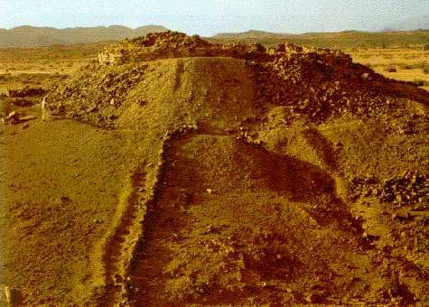
http://static.panoramio.com/photos/original/49565755.jpg Click^for a great shot of Tsindi too big to repost here. I like how they didn't make lil things such as boulders get in the way they just build right over around or beneath them.
Tsindi ruins Zimbabwe
From the interior to the coast.
Posted by -Just Call Me Jari- (Member # 14451) on :
I agree but its hard finding sources let alone images beyond the few VIA google search. This is a great thread!!
Posted by IamNomad (Member # 17656) on :
Barada
quote:@ IamNomad do you have the age of that structure?
no one knows the age of the Taalo(pyramid) to my knowledge its very ancient and no one touches in Somalia because old myths that says spirits guard it against transgressors.
Posted by Whatbox (Member # 10819) on :
City of Djado, Niger. Abandoned ruins, dating back some 800-1,000 years ago.
quote:The Kawar is an area of cliffs topped by ancient dry stone fortifications aligned north-south, forming the junction between the vast sandy Ténéré area to the west and the Great Erg Bilma east. This region has been inhabited since Neolithic times, as there are rock paintings and engravings dating to this period. She is currently a series of small oases which are among the most isolated of the Sahara. They survive in a traditional way by maintaining a caravan business. The site supports salt deposits, the principal object of trade. Large freshwater and brackish environments determine natural biological (fauna and flora) outstanding in the Sahara. It is also one of the regions that Addax is likely to use during his nomadic. The scenic beauty of this region is universally known. Kawar saw the penetration of the 666 Muslim by Ibn Nafi Uqba who took successively all the forts before seizing the capital Khawar or Qasabat Kahawar "the walled city or the citadel of Kawar. Satements of Authenticity and / or Integrity The oases of Kawar producing salt and soda are the source of the salt caravan: Ayri or tafordé (road salt) or even tarlam (the string of camels). This ecosystem has been a productive center since ancient times when various populations, Kanuri, Berber, Toubou lived symbiotically in the isolation of the Sahara. This character is reflected perrinité since ancient times and continues to this day with very little change. Comparison with Other similar properties This site of the Salt Road can be compared to the oasis of Dakhla, Farafra and Siwa in Egypt that have persisted since the Egypt Road salt Theghaza Taoudeni-old in Mali and to this day.
Niger (Africa) Date of Submission: 26/05/2006 Category: Cultural Submitted by: Ministry of Culture, Arts and Communication - Dir. Cultural Heritage and Museums State, Province or Region: Region: Arlit Department: Agadez Coordinates: N17 12-20 E8 30 6-10 57 Ref.: 5044
^Very interesting. Can we perhaps imagine developments occurring on the Djado Plateau as a precursor to Kanem-Bornu (or "Bornu")? Perhaps pressure from Islam compelled the Kanuri south and southwest into Chad and Nigeria where the later polities (Kanem-Bornu) were established?
Alternatively, can it be ruled out that this could be related to a segment of the Garamante/Turareg living in fortified towns to repel marauding nomads? It's entertainable (sic) but given the nomadic nature of the Tuareg themselves and the history of sedentism among the Kanuri, as well as a traceable continuity in statecraft among the Kanuri after the abandonment of Djado, I prefer to see them as likely being responsible for this.
^Perhaps the Bornu manuscripts and the writings of people like Ibn Fartuwa would be able to shed more light on pre-Bornu histories and lineage. I don't recall what the Kanuri say today about their own origins and migration patterns.
Posted by Brada-Anansi (Member # 16371) on :
Good work Sundjata good work,really folks all of this stuff is hiding in plain sight I do hope our Youtube crew cover all of this in their next Vid
Posted by The Old Doctore (Member # 18546) on :
quote:Originally posted by Sundjata: Alternatively, can it be ruled out that this could be related to a segment of the Garamante/Turareg living in fortified towns to repel marauding nomads? It's entertainable (sic) but given the nomadic nature of the Tuareg themselves and the history of sedentism among the Kanuri, as well as a traceable continuity in statecraft among the Kanuri after the abandonment of Djado, I prefer to see them as likely being responsible for this.
Is there any concrete evidence that the Tuareg are directly descended from the Garamente of the Libyan Fezzan?
Tuaregs are relatively recent to the region (Western Sudan). Being the descendants of Berber speaking southern Moroccans that migrated south and southwest. The Western Saharan and Mauritanian "Moors" are descended from the same Berber speaking population. Only difference being that the latter group was eventually Arabnized. These two Berber groups would have had then absorbed the indigenous Niger-Kordofanian and Nilo-Saharan populations in the region.
Tuaregs are also only found along the Algerian border of Libya.
The traditional inhabitants of the Fezzan and southern Libya in general are Toubou/Nilo-Saharan speaking. The Toubou currently make-up of 18% of the Libyan population. So logically imo, it's the Toubou and other similar groups that share a link with the ancient Garamente.
Posted by The Old Doctore (Member # 18546) on :
^^See this thread and the information/links cited therein. Neither do I rule out a substantial Toubou presence among the Garamante population either. It doesn't have to be an either/or situation (even though intra-population ethnic differences may sometimes lead to social stratification).
quote:Tuaregs are relatively recent to the region (Western Sudan). Being the descendants of Berber speaking southern Moroccans that migrated south and southwest.
Even disregarding the evidence in the above link, the Tarikhs place the Kel Tamasheq in Timbuktu as early as the 10th century so I'm not sure what you mean by "relatively recent"? Do you have any more information (texts, references, etc) about their being derived from Morocco?
quote:Tuaregs are also only found along the Algerian border of Libya.
The Tuareg have always been movers and shakers, so granted that this is true, I'm not sure it's of any consequence.
Posted by The Gaul (Member # 16198) on :
edit
Posted by alTakruri (Member # 10195) on :
Not to distract from this thread's intent maybe this can be continued in the Oral myth and Origins of the Tuaregs thread broached before the forum split.
I'll just say here the "Tuareg" are a confederacy of divers origins and they don't accept the label Tuareg regardless if it derives from Targa (one of the Sanhadja Confederacy tribes) or not.
quote:Originally posted by Sundjata: ^^See this thread and the information/links cited therein.
quote:Tuaregs are relatively recent to the region (Western Sudan). Being the descendants of Berber speaking southern Moroccans that migrated south and southwest.
Even disregarding the evidence in the above link, the Tarikhs place the Kel Tamasheq in Timbuktu as early as the 10th century so I'm not sure what you mean by "relatively recent"? Do you have any more information (texts, references, etc) about their being derived from Morocco?
Posted by The Old Doctore (Member # 18546) on :
quote:Originally posted by Sundjata: ^^See this thread and the information/links cited therein. Neither do I rule out a substantial Toubou presence among the Garamante population either. It doesn't have to be an either/or situation (even though intra-population ethnic differences may sometimes lead to social stratification).
quote:Tuaregs are relatively recent to the region (Western Sudan). Being the descendants of Berber speaking southern Moroccans that migrated south and southwest.
Even disregarding the evidence in the above link, the Tarikhs place the Kel Tamasheq in Timbuktu as early as the 10th century so I'm not sure what you mean by "relatively recent"? Do you have any more information (texts, references, etc) about their being derived from Morocco?
quote:Tuaregs are also only found along the Algerian border of Libya.
The Tuareg have always been movers and shakers, so granted that this is true, I'm not sure it's of any consequence.
The Garamantian complex is estimated to be roughly 2,500 years old, The southwards migrations of Berber speakers from southern Morocco into the Western Sudan, i.e. the Western Sahara, Mauritania, Mali etc, took place in the 3rd Century A.D. So therefore the link between the contemporary Tuareg and the Garamantes is practically impossible if you take the above into consideration. In addition, the Toubou and other settled Nilo-Saharan groups in the region have a history of state-building, i.e. Agisymba, Kanem, Kanem Bornu etc, that the Tuareg largely lack. Also the Libyan Fezzan and southern Libya is associated with the ancient Central Saharan population (likely Nilo-Saharan speaking imo) that bioculurally contributed to the Nile Valley Complex, i.e. the "Black Mummy".
Thanks for the link, I'll take a look.
Posted by Sundjata (Member # 13096) on :
^Yes, maybe we can continue the discussion in that thread (it's still an active thread), if you don't mind re posting this. You have some good points that I would like to respond to, but not here. Posted by The Explorer (Member # 14778) on :
quote:Originally posted by The Old Doctore:
The southwards migrations of Berber speakers from southern Morocco into the Western Sudan, i.e. the Western Sahara, Mauritania, Mali etc, took place in the 3rd Century A.D.
What are relying on to make this claim?
Posted by melchior7 (Member # 18960) on :
Great thread.
"According to a legend, Tin Hinan was the first leader to unite the Tuareg world and establish a kingdom in the Ahaggar mountains. She was both heroine and matriarch and is believed to have come from Tafilalt oasis in the Atlas Mountains in the area of the modern Morocco in the 4th century/5th century.
About this famous ancestress of the Tuaregs following story is told: Tin Hinan came in the company of her maid-servant Takamat from Tafilalet in the Atlas Mountains Morocco to the Hoggar Algeria. There she became the first Tamenokalt (queen) of the Tuaregs and her fame was so great, that even today the Tuaregs call her "Mother of Us All."
Abalessa, the ancient capital of the Ahaggar or Hoggar region, is the location of a famous archaeological site known as the Tomb of Tin Hinan."
The tomb
Posted by Brada-Anansi (Member # 16371) on :
^
Posted by ausar (Member # 1797) on :
An article I dug up from my archives.
Stone heads recall Africa's forgotten past By: Matthew Bunce Broadcasted on BICNews 10 February 1998 FEATURE GOHITAFLA, Ivory Coast (Reuters) - When Bernadette Vouinan tripped over a rock with eyes and a nose in 1982, she unearthed one of the first of more than 1,000 ancient stone head sculptures to emerge from Ivory Coast's pre-historic soil. The origin of the heavy granite and laterite stones of up to three feet high and 2,000 years old remains a mystery. But some villagers have no doubts, even challenging theories on East Africa's Rift Valley as the cradle of mankind. ``We believe they were created and placed in the earth here by God,'' said one farmer in the remote Marahoue valley in central Ivory Coast where many of the heads have been found. Such lore attributes flattened rocks found there to the creator's footprints as he stepped back to heaven. Farmers are often less star-struck, selling any heads they find to tourists for a pittance. Ivorian anthropologists staging an exhibition in the commercial capital Abidjan this month hope to dispel myths and spur a wider interest in promoting Africa's forgotten past. ``It means we have had art for a long time,'' said leading anthropologist Georges Niangoran-Bouah, chief researcher on Marahoue. ``And where there is art there is civilization.'' The problem is that West Africa's tropical climate means clues to history often rot, leaving only rich oral tradition. GOD'S TEST-BED FOR HUMANS ``We Africans say man was not made in a day. And the most important part of man is the head,'' Niangoran-Bouah told Reuters. Folklore says the myriad facial designs -- many Marahoue heads have no mouth, nose or eyes -- are but one sign of God's use of Marahoue as a human test-bed. Later carvings with busts and full figures show man's head at one third rather than one seventh of his height. ``African artists think God must have made a mistake,'' said Niangoran-Bouah, holding a giant-nosed head nicknamed Charles de Gaulle, one of his garden collection of 200 stones. The faces, once used in mask rituals, are said to have been buried by God to protect women and children from seeing them. But some village wives have more pressing domestic concerns. ``They are very good. They withstand the heat,'' said one cook who was using three around a fire to support her pots at Diacohou. BEFORE OUR ANCESTORS The heads have yet to be accurately dated but similar stones in Senegal date back as far as 2,000 years. ``No one knows what role the heads played in ancient times,'' Niangoran-Bouah said. ``They are not the work of men known to us or our ancestors,'' said Ta-bi-Tra, a hunter at Gohitafla, now inhabited by Ivorian President Henri Konan Bedie's ruling Baoule tribe. Baoule warriors arrived there under Queen Abla Pokou in the 17th century, displacing Gouro tribes who in turn had pushed out the Wan culture in the 15th century. ``The Wan consider them to be ancestral objects,'' said Niangoran-Bouah, citing the stories of nearby Wan descendants, including a theory that the heads betrayed them to the enemy. The heads are also seen as grave charms for Wan warriors, homes for dead mens' souls or guardian spirits and talismans. ``We make offerings for a safe voyage, to find a good partner or fight off evil sorcerers, eaters of souls, jealous people and poisoners,'' said one soothsayer. ``We trust them.'' Animal sacrifices in cult rituals ensured successful childbirth and stone heads still play a part in ritual exorcisms and purification of adulterers. One man described being inhabited by a spirit from stones surrounding his house. ``I have 13 children, they all come from the stones.'' Prehistoric stone heads have been found around the world, from Africa to Europe and America. Marahoue's are thought to be among the largest and oldest along Africa's Atlantic coast. Ivorian standing stones are larger than average and found deeper in the ground than similar African examples, suggesting a greater age of up to 7,000 years, Niangoran-Bouah said. Such African megaliths weighing between half a ton and 15 tons are found in a northwestern strip on the Mediterranean and pockets in a wide west-east sub-Saharan band between Senegal and Kenya. Villagers showed Reuters a 19-foot rock said to be one of the largest African megaliths. In Mali, to the north, anthropologists have been baffled by the Dogon culture's ability to predict cycles of an invisible satellite of the star Sirius, which appears every 60 years. The Dogon, whose God Amma is said to have thrown a ball of clay into space to create Earth, is just one example of deep civilization in Africa often brushed over by colonists. ``This civilization before the pre-colonial period honorsour country,'' Niangoran-Bouah said. ``During colonial times the stones were probably kept hidden in the forest. The whites did not see them.'' That, for better or worse, is no longer the case. � Copyright 1998, Reuters News Service
Posted by Sundjata (Member # 13096) on :
^Great find ausar! I wish there were photos. I wonder if the Senegalese culture/s responsible for the stone heads were related in some way to those responsible for the monoliths. Maybe digging deeper into Wan ethnography will reveal something interesting.
Posted by alTakruri (Member # 10195) on :
Courtesy of the "thieves" Galerie & Librairie www.arts-primitifs.com Posted by Sundjata (Member # 13096) on :
^Good sh1t alTakuri! Just saved it to my hard drive, appreciate the contribution.
Posted by kikuyu2 (Member # 19316) on :
OP thanks for this thread! Its true-sometimes we go far overlooking what stares us in the face right here at home. Thanks again!
Posted by kikuyu2 (Member # 19316) on :
This is an addendum:I think it would help if we had our own Afrocentrists doing PRIMARY RESEARCH here in Africa and elsewhere. That way such ancient developments wouldn't remain mysterious-imagine if we had our own well funded research teams across the continent. Without the distortions and lies of the Ice People!IMHO we'd uncover a veritable sea of knowledge.
Posted by Sundjata (Member # 13096) on :
^This has been the problem for years kikuyu2. One major issue is with funding since we have to convince these institutions that there's something there to study in the first place. Also our own Black researchers either don't seem to be interested in Africa or are more narrowly focused on American affairs. We need talented people who know where to look and who have the motivation to do so. Cameroon may be a new hot spot according to recent reports, but what Black researchers are working there? Augustin Holl deserves praise for his work on the Senegalese monoliths but how many people have heard or care about them?
Posted by Sundjata (Member # 13096) on :
^Why have I rarely if ever seen these kind of examples of Ife architecture? Why is the Yoruba art work so much more ubiquitous?
Exterior of Palace in Ife, Nigeria (Leo Frobenius Expedition, 1910)
Uploaded with ImageShack.us Posted by malibudusul (Member # 19346) on :
The true story of Great Zimbabwe 23/09/2011 00:00:00
quote:Originally posted by Brada-Anansi: Calabooz African archeology is still in it's infancy there are hundreds of sites like this scattered through out Africa only funding and lack of general interest caused places like this to be hidden in plain sight.
This is so true Brada. Thanks for the post.
Posted by dana marniche (Member # 13149) on :
quote:Originally posted by ausar: An article I dug up from my archives.
Stone heads recall Africa's forgotten past By: Matthew Bunce Broadcasted on BICNews 10 February 1998 FEATURE GOHITAFLA, Ivory Coast (Reuters) - When Bernadette Vouinan tripped over a rock with eyes and a nose in 1982, she unearthed one of the first of more than 1,000 ancient stone head sculptures to emerge from Ivory Coast's pre-historic soil. The origin of the heavy granite and laterite stones of up to three feet high and 2,000 years old remains a mystery. But some villagers have no doubts, even challenging theories on East Africa's Rift Valley as the cradle of mankind. ``We believe they were created and placed in the earth here by God,'' said one farmer in the remote Marahoue valley in central Ivory Coast where many of the heads have been found. Such lore attributes flattened rocks found there to the creator's footprints as he stepped back to heaven. Farmers are often less star-struck, selling any heads they find to tourists for a pittance. Ivorian anthropologists staging an exhibition in the commercial capital Abidjan this month hope to dispel myths and spur a wider interest in promoting Africa's forgotten past. ``It means we have had art for a long time,'' said leading anthropologist Georges Niangoran-Bouah, chief researcher on Marahoue. ``And where there is art there is civilization.'' The problem is that West Africa's tropical climate means clues to history often rot, leaving only rich oral tradition. GOD'S TEST-BED FOR HUMANS ``We Africans say man was not made in a day. And the most important part of man is the head,'' Niangoran-Bouah told Reuters. Folklore says the myriad facial designs -- many Marahoue heads have no mouth, nose or eyes -- are but one sign of God's use of Marahoue as a human test-bed. Later carvings with busts and full figures show man's head at one third rather than one seventh of his height. ``African artists think God must have made a mistake,'' said Niangoran-Bouah, holding a giant-nosed head nicknamed Charles de Gaulle, one of his garden collection of 200 stones. The faces, once used in mask rituals, are said to have been buried by God to protect women and children from seeing them. But some village wives have more pressing domestic concerns. ``They are very good. They withstand the heat,'' said one cook who was using three around a fire to support her pots at Diacohou. BEFORE OUR ANCESTORS The heads have yet to be accurately dated but similar stones in Senegal date back as far as 2,000 years. ``No one knows what role the heads played in ancient times,'' Niangoran-Bouah said. ``They are not the work of men known to us or our ancestors,'' said Ta-bi-Tra, a hunter at Gohitafla, now inhabited by Ivorian President Henri Konan Bedie's ruling Baoule tribe. Baoule warriors arrived there under Queen Abla Pokou in the 17th century, displacing Gouro tribes who in turn had pushed out the Wan culture in the 15th century. ``The Wan consider them to be ancestral objects,'' said Niangoran-Bouah, citing the stories of nearby Wan descendants, including a theory that the heads betrayed them to the enemy. The heads are also seen as grave charms for Wan warriors, homes for dead mens' souls or guardian spirits and talismans. ``We make offerings for a safe voyage, to find a good partner or fight off evil sorcerers, eaters of souls, jealous people and poisoners,'' said one soothsayer. ``We trust them.'' Animal sacrifices in cult rituals ensured successful childbirth and stone heads still play a part in ritual exorcisms and purification of adulterers. One man described being inhabited by a spirit from stones surrounding his house. ``I have 13 children, they all come from the stones.'' Prehistoric stone heads have been found around the world, from Africa to Europe and America. Marahoue's are thought to be among the largest and oldest along Africa's Atlantic coast. Ivorian standing stones are larger than average and found deeper in the ground than similar African examples, suggesting a greater age of up to 7,000 years, Niangoran-Bouah said. Such African megaliths weighing between half a ton and 15 tons are found in a northwestern strip on the Mediterranean and pockets in a wide west-east sub-Saharan band between Senegal and Kenya. Villagers showed Reuters a 19-foot rock said to be one of the largest African megaliths. In Mali, to the north, anthropologists have been baffled by the Dogon culture's ability to predict cycles of an invisible satellite of the star Sirius, which appears every 60 years. The Dogon, whose God Amma is said to have thrown a ball of clay into space to create Earth, is just one example of deep civilization in Africa often brushed over by colonists. ``This civilization before the pre-colonial period honorsour country,'' Niangoran-Bouah said. ``During colonial times the stones were probably kept hidden in the forest. The whites did not see them.'' That, for better or worse, is no longer the case. � Copyright 1998, Reuters News Service
Photos of these giant stone heads in the Ivory Coast are in one of Dr. Van Sertima's books, but I forget which one.
Posted by dana marniche (Member # 13149) on :
quote:Originally posted by melchior7: Great thread.
"According to a legend, Tin Hinan was the first leader to unite the Tuareg world and establish a kingdom in the Ahaggar mountains. She was both heroine and matriarch and is believed to have come from Tafilalt oasis in the Atlas Mountains in the area of the modern Morocco in the 4th century/5th century.
About this famous ancestress of the Tuaregs following story is told: Tin Hinan came in the company of her maid-servant Takamat from Tafilalet in the Atlas Mountains Morocco to the Hoggar Algeria. There she became the first Tamenokalt (queen) of the Tuaregs and her fame was so great, that even today the Tuaregs call her "Mother of Us All."
Abalessa, the ancient capital of the Ahaggar or Hoggar region, is the location of a famous archaeological site known as the Tomb of Tin Hinan."
The tomb
These stone structures or tombs called "argem" are the same as stretch to Nubia and Abyssinia.
Hoggar Tuareg boy. Posted by Sundjata (Member # 13096) on :
"In 1903, Kano's city walls (above) were regarded as West Africa's most impressive monument. They were 25km long and up to 18m high with narrow fortified gateways. In the mid-C19th, Barth could not get his laden camels through most of the gates; and the above reconstruction has been widened to cater for motor traffic."
"Above - in situ ruins in the early 1990's. The Kano City walls were considered the most impressive monument in West Africa in 1903; but they have become severely eroded today, with borrow-pits for housing encroaching from both sides, and the nouveaux riches building ostentatious houses right across the old wall. Most gateways have had to be modified to allow modern traffic; but at least one gateway may now be restored authentically with some sections of the wall alongside".
"Below: Reconstruction of the Kano City wall at the Museum of Traditional Nigerian Architecture in Jos, where higher rainfall conditions have meant constant repair work. The upper parapet was manned by archers and riflemen using loopholes in the wall; whilst cavalry moved rapidly around inside the walls to ensure protection at the weakest spots. The walls were built entirely of tubali - pear-shaped, sun-dried mud blocks to create a 24 km long, 20m high perimeter".
"Old Ningi was a nineteenth century cult settlement (ruins above) opposing Kano, Zaria and Bauchi from its hill fortress base using up to 4,000 cavalary. Its mud walls (below) were built on stone-based parapets and presented a complex defence strategy, which the larger kingdoms were unable to breach. It was captured by the British using a local traitor to show a secret way in near the beginning of the C20th".

![[Eek!]](eek.gif)


![[Smile]](smile.gif)


![[Big Grin]](biggrin.gif)